

A method and system for map framing based on adaptive scale measurement
A scale, self-adaptive technology, applied in the directions of maps/plans/charts, educational appliances, instruments, etc., can solve problems such as unfavorable and low work efficiency, and achieve the effect of improving work efficiency, fast computing speed, and shortening data processing time.
- Summary
- Abstract
- Description
- Claims
- Application Information
AI Technical Summary
Problems solved by technology
Method used
Image

Examples
Embodiment 1
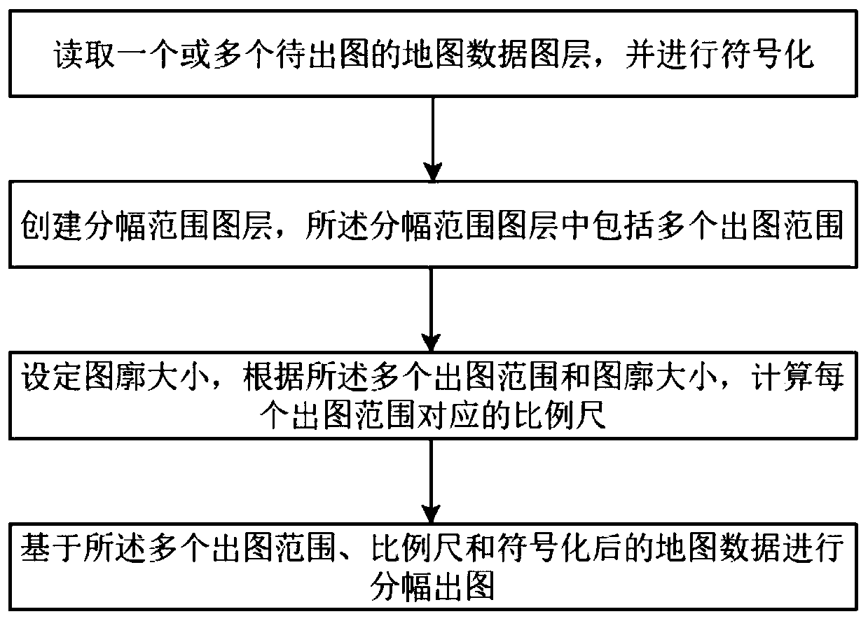
[0057] This embodiment discloses a method for producing maps based on adaptive scale measurement and calculation, including the following steps:
[0058] Step 1: Read and symbolize one or more map data layers to be plotted;
[0059] Step 2: Create a framing range layer, and the framing range layer includes multiple drawing ranges;
[0060] Step 3: Set the size of the graph outline, and calculate a scale suitable for the size of the graph outline for each graph output range according to the multiple graph output ranges and the graph outline size;
[0061] Step 4: Based on the multiple drawing ranges and scales, perform framing and pre-drawing the picture to be confirmed by the user, and perform step 5 after the user confirms;
[0062] Step 5: Perform framing and outputting based on the plurality of outputting ranges, scales and symbolized map data.
[0063] In the step 2, the framing range layer is a line layer or a surface layer, and the drawing range is a polygon element or...
Embodiment 2
[0120] The purpose of this embodiment is to provide a framing and drawing system.
[0121] A map framing system based on adaptive scale measurement, including a memory, a processor, and a computer program stored on the memory and operable on the processor, when the processor executes the program, the following steps are implemented, including :
[0122] Read one or more map data layers to be drawn, and receive the user's symbolic operation;
[0123] Create a framing range layer, which includes a plurality of drawing ranges in the framing range layer;
[0124] Receive the setting of the size of the graph outline, and calculate a scale suitable for the size of the graph outline for each graph output range according to the multiple graph output ranges and the graph outline size;
[0125] Framing and plotting are performed based on the plurality of plotting ranges, scales and symbolized map data.
Embodiment 3
[0127] The purpose of this embodiment is to provide a computer-readable storage medium.
[0128] A computer-readable storage medium, on which a computer program is stored, and when the program is executed by a processor, the following steps are performed:
[0129] Read one or more map data layers to be drawn, and receive the user's symbolic operation;
[0130] Create a framing range layer, which includes a plurality of drawing ranges in the framing range layer;
[0131] Receive the setting of the size of the graph outline, and calculate a scale suitable for the size of the graph outline for each graph output range according to the multiple graph output ranges and the graph outline size;
[0132] Framing and plotting are performed based on the plurality of plotting ranges, scales and symbolized map data.
PUM
 Abstract
Description
Claims
Application Information