Navigation testing method and system simulating walking inertia free of satellite signal

An inertial navigation and satellite signal technology, applied in the field of navigation and positioning, to achieve the effect of accurate positioning results

Active Publication Date: 2018-11-27
QIANXUN SPATIAL INTELLIGENCE INC
View PDF6 Cites 3 Cited by
  • Summary
  • Abstract
  • Description
  • Claims
  • Application Information

AI Technical Summary

Problems solved by technology

[0006] The present invention proposes a pedestrian inertial navigation test method and system simulating no satellite signals, which solves the problem of no centimeter-level high-precision positioning reference equipment for pure pedestrian inertial navigation tests

Method used


Image

  • Navigation testing method and system simulating walking inertia free of satellite signal
  • Navigation testing method and system simulating walking inertia free of satellite signal
  • Navigation testing method and system simulating walking inertia free of satellite signal

Examples


Embodiment Construction

[0027] Hereinafter, the present invention will be further described in conjunction with the drawings and embodiments.

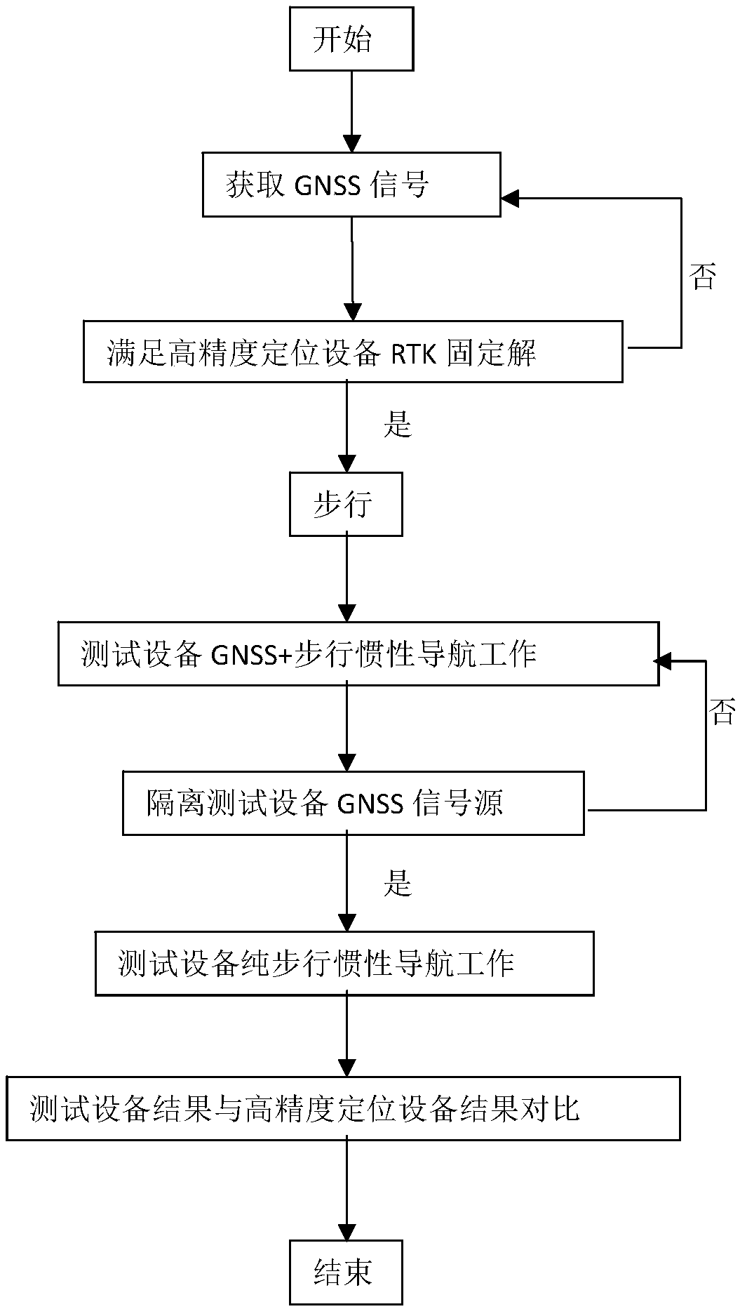
[0028] figure 1 It is a flowchart of the present invention. As shown in the figure, the test equipment and high-precision positioning equipment are in an open environment. The high-precision positioning equipment obtains information such as the carrier phase of the GNSS signal in the current environment, and obtains nearby positioning services through the RTK account of the positioning service provider. Carrier phase information of the supplier’s CORS (Continuously Operating Reference Stations, continuously operating reference stations), and then use the RTK algorithm to obtain a centimeter-level RTK fixed solution, and at the same time generate a result file with corresponding time and latitude and longitude coordinate information; walk for a while (such as: 3-10 minutes) Complete the initialization of the walking inertial navigation of the test equipment, i...


PUM


Abstract

The invention provides a navigation testing method and system simulating walking inertia free of a satellite signal. Testing equipment and high-precision positioning equipment are in a wide environment. The high-precision positioning equipment acquires carrier phase information of a GNSS signal. Carrier phase information of a nearby positioning service supplier CORS is acquired through a RTK account number of the positioning service supplier; a centimetre-level RTK fixed solution is calculated by means of an algorithm, and meanwhile, a result document with corresponding coordinate informationis generated; walking inertial navigation of the testing equipment is initialized after walking for a period of time, and a GNSS signal source of the testing equipment is isolated, so that the testingequipment enters a pure walking inertial navigation working mode and meanwhile, the high-precision positioning equipment further acquires centimetre-scaled RTK fixed solution walking result document,and the walking result document, with coordinates, of the testing equipment and the positioning result document of the high-precision positioning equipment are compared to obtain accurate error statistics. The positioning result of the testing equipment is more accurate.

Description

technical field [0001] The invention relates to the technical field of navigation and positioning, in particular to a method and system for simulating pedestrian inertial navigation without satellite signals. Background technique [0002] Pedestrian inertial navigation is a technology that uses the parameters of the accelerometer and gyroscope during walking to perform integral calculations to obtain the current position; in places with better satellite signals, pedestrian inertial navigation (referred to as inertial navigation) will be combined with GNSS results Positioning, in an environment without satellite signals, completely relies on pure pedestrian inertial navigation technology. In the application test of pedestrian inertial navigation, to evaluate the positioning performance of pure pedestrian inertial navigation, it is necessary to enter the environment without satellite signals for testing. [0003] When evaluating the positioning performance of pedestrian inerti...

Claims


Application Information

Patent Timeline
Patent Type & Authority Applications(China)
IPC IPC(8): G01C21/16G01C25/00G01S19/49
CPCG01C21/165G01C25/005G01S19/49
Inventor 高求兵
Owner QIANXUN SPATIAL INTELLIGENCE INC
Why Eureka
Try Eureka