Multi-source data fusion real-time navigation positioning method and system

A technology of navigation and positioning and multi-source data, which is applied in the field of navigation and positioning, and can solve problems such as the inability to realize navigation and positioning and the reduction of GNSS positioning accuracy

Inactive Publication Date: 2020-04-10
CHINA UNIV OF GEOSCIENCES (BEIJING)
View PDF7 Cites 11 Cited by
  • Summary
  • Abstract
  • Description
  • Claims
  • Application Information

AI Technical Summary

Problems solved by technology

For example, when in an environment such as urban canyons, tunnels, viaducts, tree shades, etc., which are likely t...

Method used


Image

  • Multi-source data fusion real-time navigation positioning method and system
  • Multi-source data fusion real-time navigation positioning method and system
  • Multi-source data fusion real-time navigation positioning method and system

Examples


Embodiment 1

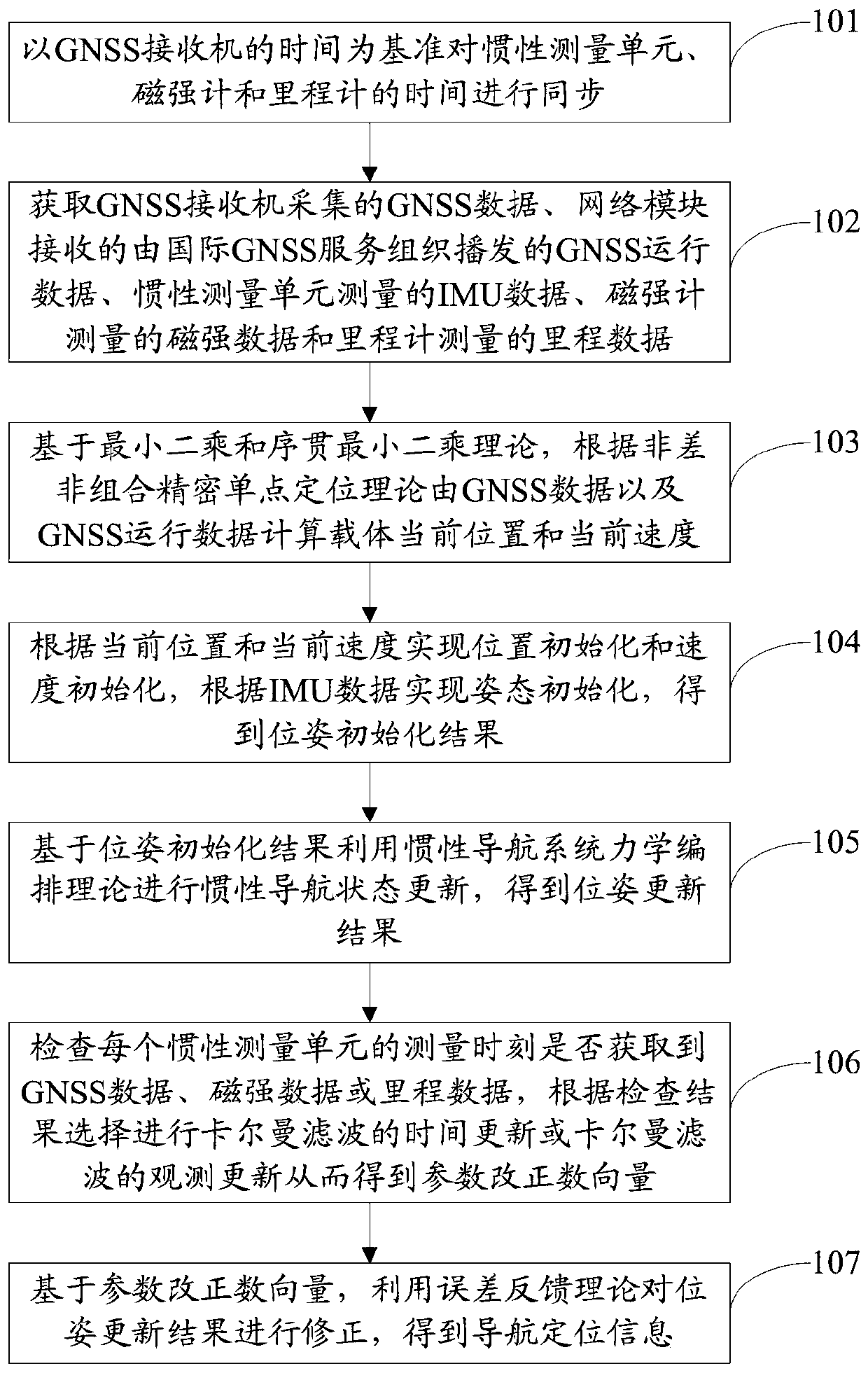
[0065] figure 2 It is a method flowchart of the multi-source data fusion real-time navigation and positioning method in Embodiment 1.

[0066] see figure 2 , the navigation positioning method includes:

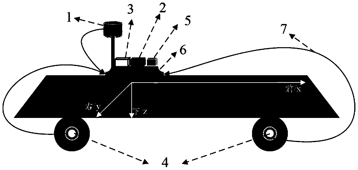
[0067] Step 101: Synchronize the time of the inertial measurement unit, the magnetometer and the odometer with the time of the GNSS receiver as a reference.

[0068] Based on the electronic signal time synchronization theory, during data transmission, GNSS time (toc GNSS ) as a benchmark, by comparing the local time (reciver_t sensors,m ) and the local time when the GNSS data is transmitted to the FPGA board (reciver_t GNSS ) between the time difference:

[0069]

[0070] Calculate time for each sensor

[0071]

[0072] The initial time toc of IMU, magnetometer, and ODO data calculated according to formula (2) based on GNSS time sensors,IMU,0 、toc sensors,GMNS,0 and toc sensors,ODO,0 . Thereafter, the time of IMU, magnetometer, and ODO data in k epochs can be...

Embodiment 2

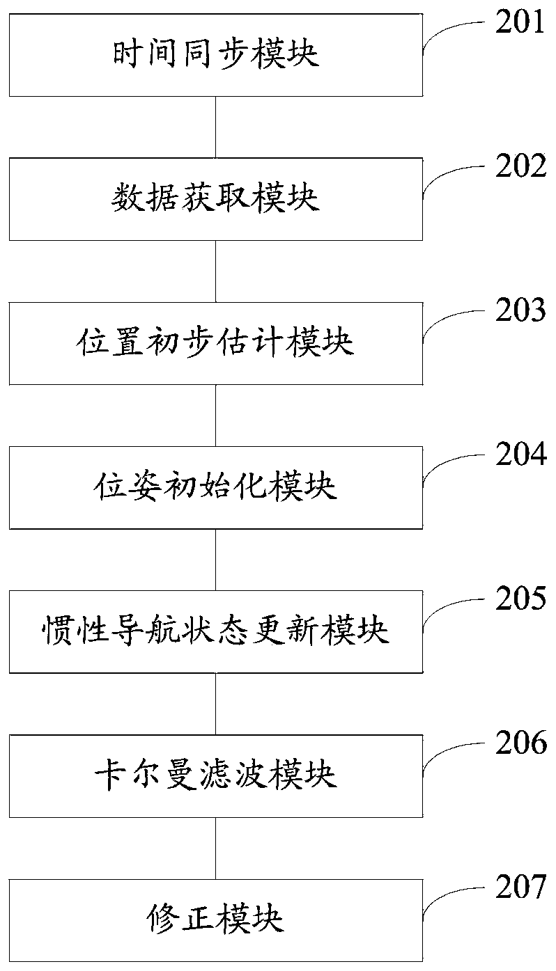
[0168] Embodiment 2 provides a multi-source data fusion real-time navigation and positioning system.

[0169] image 3 It is a system structure diagram of a multi-source data fusion real-time navigation and positioning system according to Embodiment 2 of the present invention.

[0170] see image 3 , the navigation and positioning system includes:

[0171] The time synchronization module 201 is configured to synchronize the time of the inertial measurement unit, the magnetometer and the odometer with the time of the GNSS receiver as a reference.

[0172]The data acquisition module 202 is used to obtain the GNSS data collected by the GNSS receiver, the GNSS operation data broadcast by the international GNSS service organization received by the network module, the IMU data measured by the inertial measurement unit, the magnetic intensity data measured by the magnetometer and the odometer Measured mileage data.

[0173] The preliminary position estimation module 203 is used t...


PUM


Abstract

The invention discloses a multi-source data fusion real-time navigation positioning method and system. The method comprises: acquiring GNSS data, GNSS operation data broadcasted by IGS, IMU data, magnetic intensity data and mileage data; calculating the current position and speed according to the GNSS data and the GNSS operation data; achieving position and speed initialization according to the current position and speed, and achieving posture initialization according to IMU data to obtain a posture initialization result; performing inertial navigation state updating based on the pose initialization result to obtain a pose updating result; checking whether GNSS data, obtaining magnetic intensity data or mileage data at each measurement moment of the inertial measurement unit or not, and selecting time updating or observation updating of Kalman filtering according to a checking result to obtain a parameter correction vector; and correcting the pose updating result by utilizing an errorfeedback theory based on the parameter correction number vector to obtain navigation positioning information. According to the invention, the positioning precision in a signal unlocking environment can be improved.

Description

technical field [0001] The invention relates to the field of navigation and positioning, in particular to a multi-source data fusion real-time navigation and positioning method and system. Background technique [0002] At present, the Global Navigation Satellite System (GNSS) is an indispensable and important technical means in the field of dynamic navigation and location services. Users broadcast and modulate radio carrier signals including ranging codes, satellite orbit and satellite clock parameters, and time information. Using precise positioning algorithms, it can provide users with high-precision position, speed, and time information. Compared with traditional positioning methods, satellite positioning systems have the advantages of global coverage, all-weather, real-time, high precision, and bounded error. [0003] However, GNSS, as a means of radio navigation and positioning, is becoming more and more widely used, but its own shortcomings are also becoming more and ...

Claims


Application Information

Patent Timeline
IPC IPC(8): G01S19/47G01S19/40G01C21/16G01C21/08
CPCG01S19/47G01S19/40G01C21/165G01C21/08
Inventor 高周正吕洁
Owner CHINA UNIV OF GEOSCIENCES (BEIJING)
Why Eureka
Try Eureka