A geological big data platform for urban planning and construction

A big data platform and urban planning technology, applied in the field of urban construction, can solve problems such as hidden dangers, unsatisfactory monitoring results, and safety issues

Inactive Publication Date: 2018-12-07
中佳勘察设计有限公司
View PDF3 Cites 4 Cited by
  • Summary
  • Abstract
  • Description
  • Claims
  • Application Information

AI Technical Summary

Problems solved by technology

[0004] Urban construction is an important part of urban management. Urban construction is based on planning. The urban living environment is transformed through construction projects, and various material facilities in the urban system are constructed. The content of urban construction includes the maintenance of various material facilities in the urban system. The physical form is the basic and phased work to create good conditions for the management of the city. It is a special economic work with obvious process and periodicity. After the city is planned and constructed, it will be put into operation and function, and provide services. Citizens create a good living environment, guarantee the normal life of citizens, and serve the economic and social development of the city. Therefore, urban construction is based on urban planning and ultimately serves urban operation. It is divided into urban spiritual civilization construction and architectural physical construction. Before construction planning and construction, it is necessary to monitor the geology, but the monitoring effect of the existing monitoring devices is not ideal, resulting in hidden safety hazards in urban planning and construction. Therefore, we propose a geological big data platform for urban planning and construction

Method used


Image

  • A geological big data platform for urban planning and construction

Examples


Embodiment Construction

[0017] The following will clearly and completely describe the technical solutions in the embodiments of the present invention with reference to the accompanying drawings in the embodiments of the present invention. Obviously, the described embodiments are only some, not all, embodiments of the present invention. Based on the embodiments of the present invention, all other embodiments obtained by persons of ordinary skill in the art without making creative efforts belong to the protection scope of the present invention.

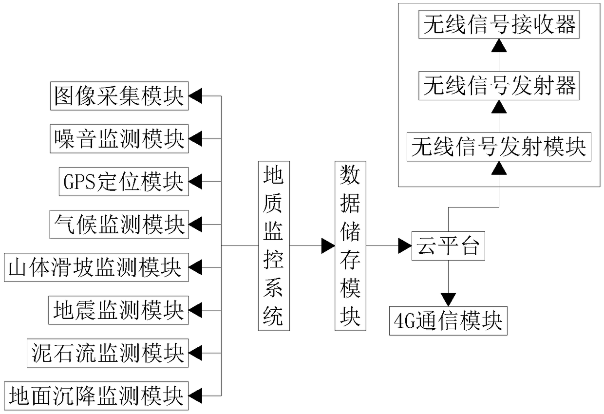
[0018] see figure 1 , a geological big data platform for urban planning and construction, including a geological monitoring system, a cloud platform, a wireless signal transmission module and a 4G communication module, the geological monitoring system includes an image acquisition module, a noise monitoring module, a GPS positioning module, a climate Monitoring module, landslide monitoring module, earthquake monitoring module, debris flow monitoring module and...


PUM


Abstract

The invention discloses a geological big data platform for urban planning and construction. The platform includes a geological monitoring system, a cloud platform, a wireless signal emission module and a 4G communication module. The geological monitoring system includes an image acquisition module, a noise monitoring module, a GPS positioning module, a climate monitoring module, a landslide monitoring module, an earthquake monitoring module, a debris flow monitoring module and a land subsidence monitoring module. The platform is provided with the image acquisition module, the noise monitoringmodule, the GPS position module, the climate monitoring module, the landslide monitoring module, the earthquake monitoring module, the debris flow monitoring module and the land subsidence monitoringmodule, so the platform can carry on the image acquisition to the surroundings, noise monitoring, climate monitoring, landslide monitoring, earthquake monitoring, debris flow monitoring and land subsidence monitoring, and is conducive to urban planning and construction. At the same time, through the role of the 4G communication module, monitoring results can be sent to people's 4G smartphones in real time, which is conducive to the emergency response of relevant people.

Description

technical field [0001] The invention relates to the technical field of urban construction, in particular to a geological big data platform for urban planning and construction. Background technique [0002] Cities are also called urban settlements, which are large settlements formed by the agglomeration of non-agricultural industries and non-agricultural populations. The densely populated areas are called cities, which generally include residential areas, industrial areas, and commercial areas and have administrative jurisdiction. The administrative jurisdiction function of the city may involve a wider area than itself, including residential areas, streets, hospitals, schools, public green spaces, office buildings, commercial stores, squares, parks and other public facilities. [0003] A city is a compound word of "city" and "city". "City" is mainly for defense and is surrounded by a city wall. "city" refers to the place where transactions are carried out, and "the day and C...

Claims


Application Information

Patent Timeline
Patent Type & Authority Applications(China)
IPC IPC(8): G06F17/30G06Q10/06H04W4/14
CPCG06Q10/0635H04W4/14
Inventor 张拥军刘宏丽侯吉鹰张军禄冯翠娜王利飞徐坤韩东旭董远照刘晓王杰
Owner 中佳勘察设计有限公司
Why Eureka
Try Eureka