Drone route planning method in mountainous area with flight safety degree being restrained

A technology of flight safety and path planning, applied in the field of drones, can solve the problems of high risk of path, slow calculation speed, and inability to accurately judge the degree of path safety, so as to improve calculation rate, intuitive safety, and reduce complexity Effect

Inactive Publication Date: 2018-12-11
北航(四川)西部国际创新港科技有限公司
View PDF5 Cites 13 Cited by
  • Summary
  • Abstract
  • Description
  • Claims
  • Application Information

AI Technical Summary

Problems solved by technology

[0005] The disadvantages of the Dijstra algorithm for planning the flight path of the UAV are: 1. When the distance between adjacent obstacles is relatively close, the path is more dangerous; 2. When there are too many initial solutions, the calculation speed is slow; 3. It cannot be accura

Method used


Image

  • Drone route planning method in mountainous area with flight safety degree being restrained
  • Drone route planning method in mountainous area with flight safety degree being restrained
  • Drone route planning method in mountainous area with flight safety degree being restrained

Examples


Embodiment Construction

[0029] In order to make the object, technical solution and advantages of the present invention clearer, the following examples are given to further describe the present invention in detail.

[0030] A method for path planning of unmanned aerial vehicles with flight safety constraints in mountainous areas, comprising the following steps:

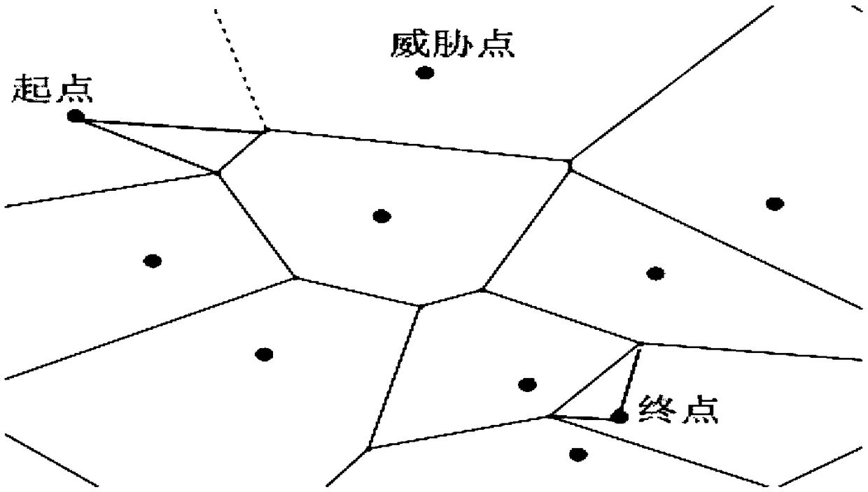
[0031] Step 1, combine the starting point, target point and obstacle location to establish a Voronoi diagram to form the initial solution of the path, such as figure 1 ;

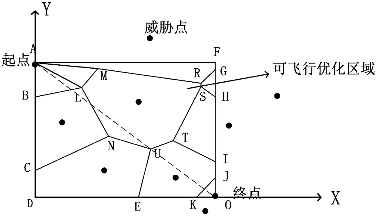
[0032] Step 2, make a rectangle with the starting point and end point as the diagonal line, and the flyable path is in the rectangular area, including the rectangular sides, such as figure 2 ;

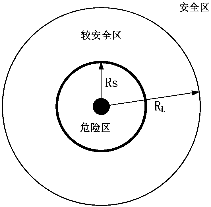
[0033] Step 3, such as image 3 As shown, the threat of obstacles is replaced by a circle with a radius of R (threat area), R L Outside the safety zone, R L with R S The area between is a relatively safe area, R S The area within is the danger zone. Set three levels for the...


PUM


Abstract

The invention discloses a drone route planning method in a mountainous area with the flight safety degree being restrained. The drone route planning method comprises the following steps that 1, a Voronoi pattern is built by combining the starting point, the target point and the position where a barrier is located, the initial solution of the route is formed; 2, a rectangle is formed by taking thestarting point and the ending part as diagonal lines, and the areas in the rectangle are the flight routes; 3, a dangerous area, a relatively safe area and a safe area are drawn by taking the barrieras the circle center, and the route safety is estimated; 4, screening is conducted according to different route safety requirements and the effect range route of a threatening area, and the route which cannot meet the safety requirement is excluded; and 5, the rest routes are equivalent to a network drawing, the shortest route is selected by using Dijkstra algorithm. The drone route planning method has the advantages that 1, the route can be selected according to the different safety requirements; 2, the feasible solutions are screened by combining the safety requirement of the route, the complexity of the network drawing is lowered, and the calculation rate of the Dijkstra algorithm is improved; and 3, the safety of the route is directly reflected.

Description

technical field [0001] The invention relates to the technical field of unmanned aerial vehicles, in particular to a path planning method for an unmanned aerial vehicle with flight safety constraints in mountainous areas. Background technique [0002] With the development of drone technology, drones are used in more and more fields, such as: agricultural plant protection, material delivery, data collection, cultural media, etc. In recent years, the development of UAVs has been extremely rapid, and the manufacturing cost has become lower and lower. As the isolated operation mode is gradually difficult to meet the growing application requirements of UAVs, more UAVs will fly into the integrated airspace in the future. The collision problem of manned aircraft, birds and other aerial objects has become increasingly prominent. In the field of material delivery, obstacles such as trees and wires that appear during the flight of the drone will affect the accuracy of the delivery of ...

Claims


Application Information

Patent Timeline
IPC IPC(8): G01C21/20
CPCG01C21/20
Inventor 唐立郝鹏张学军
Owner 北航(四川)西部国际创新港科技有限公司
Why Eureka
Try Eureka