Method for determining signal blind area, method and device for determining user position

A technology of signal blind area and target location, which is applied in the field of determining user location and signal blind area, which can solve the problems of inability to accurately determine signal blind area, inability to determine real-time location, and inability to obtain real-time location of user equipment, etc., achieving high accuracy, Accurately Acquired Effects

Active Publication Date: 2021-11-02
BEIJING DIDI INFINITY TECH & DEV
View PDF15 Cites 0 Cited by
  • Summary
  • Abstract
  • Description
  • Claims
  • Application Information

AI Technical Summary

Problems solved by technology

[0003] At present, due to various factors (such as tunnels, bridges, mountains and other special terrains, or differences in the base station coverage areas of mobile network operators), there are often many signal blind spots (such as mobile signal blind spots or GPS signal blind spots) in the actual geographical location. blind spots), when a user device is within these dead spots, it is nearly impossible to determine its real-time location
In related technologies, it is still impossible to accurately determine the signal blind areas distributed geographically, so that it is impossible to obtain the real-time location of the user equipment in the signal blind areas

Method used


Image

  • Method for determining signal blind area, method and device for determining user position
  • Method for determining signal blind area, method and device for determining user position
  • Method for determining signal blind area, method and device for determining user position

Examples


Embodiment Construction

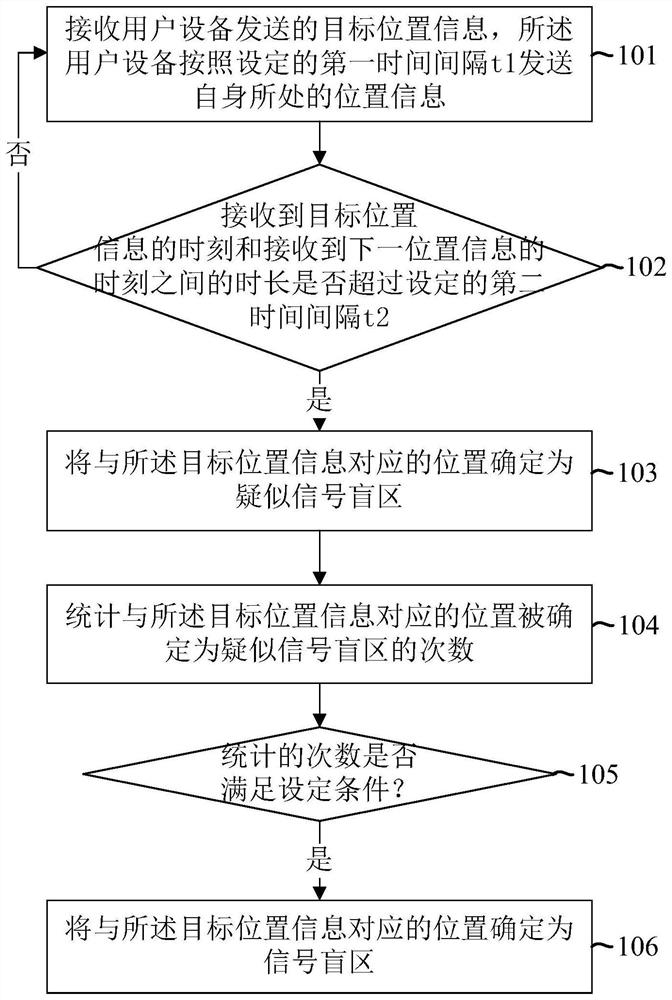
[0041] In real life, many services require accurate real-time location of users to support. For example, geographical location-based online car-hailing order distribution, GPS navigation, etc. In related technologies, generally in order to obtain the real-time location of the user equipment (UE), it is necessary for the user equipment to establish a long connection with a server (such as an online car-hailing application server), so that the user equipment sends its own GPS coordinates to the server at a certain frequency . Generally, the data format of GPS coordinates is as follows:

[0042] GPS coordinates = (lon, lat, time, speed), where lon is the longitude coordinate, lat is the latitude coordinate, time is the moment when the GPS coordinate is uploaded, and speed is the movement speed.

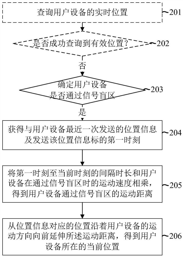
[0043] Generally, an electronic map includes a road network composed of several roads, and each point in the road network corresponds to a GPS coordinate. Based on the pre-generated r...


PUM


Abstract

A method for determining a signal blind area, a method and a device for determining a user position. Wherein, the method for determining the signal blind area includes: receiving target location information sent by user equipment, wherein the user equipment sends its own location information according to a set first time interval t1; when receiving the target location information When the time between the moment of receiving the next location information exceeds the set second time interval t2, the location corresponding to the target location information is determined as a suspected signal blind area, where t2≥t1; statistics and the The number of times that the position corresponding to the target position information is determined as a suspected signal blind area; when the counted times meet the set condition, the position corresponding to the target position information is determined as a signal blind area.

Description

technical field [0001] The present application relates to the field of positioning technology, in particular to a method for determining a signal blind area, a method and a device for determining a user position. Background technique [0002] In many fields, there is a need to obtain a real-time location of a user equipment (User Equipment, UE) through a Global Positioning System (Global Positioning System, GPS). For example, in some map or navigation applications, the road network location where the user equipment is located needs to be determined according to the GPS coordinates sent by the user equipment. [0003] At present, due to various factors (such as special terrains such as tunnels, bridges, and mountains, or differences in the coverage areas of base stations of mobile network operators), there are often many signal blind spots (such as mobile signal blind spots or GPS signal blind spots) in the actual geographical location. dead zone), when the user equipment is...

Claims


Application Information

Patent Timeline
Patent Type & Authority Patents(China)
IPC IPC(8): H04W4/029G01S19/42
CPCH04W4/02G01S19/42
Inventor 李炎
Owner BEIJING DIDI INFINITY TECH & DEV
Why Eureka
Try Eureka