Method and device for generating unmanned aerial vehicle route

A technology for drones and routes, applied in the field of drones, can solve the problems of data processing prone to loopholes, low image accuracy, missing corners, etc.

Active Publication Date: 2018-12-18
GUANGZHOU XAIRCRAFT TECH CO LTD
View PDF6 Cites 16 Cited by
  • Summary
  • Abstract
  • Description
  • Claims
  • Application Information

AI Technical Summary

Problems solved by technology

However, when the residual value of the distance between the long side of the surveying area and the strip is not 0, since the calculated strip spacing is generally fixed and will not be changed, and the strip spacing is greater than the residual value of the long side, it cannot meet the requirements to continue generating a Airline operating rules
[0004] Therefore, if the UAV performs surveying and mapping operations according to the route generated by the existing technology, the accuracy of the collected images at the edge of the surveying and mapping area will be low during the actual surveying and mapping, and problems such as loopholes and missing corners will easily appear in the later data processing.

Method used


Image

  • Method and device for generating unmanned aerial vehicle route
  • Method and device for generating unmanned aerial vehicle route
  • Method and device for generating unmanned aerial vehicle route

Examples


Embodiment Construction

[0094] In order to make the above objects, features and advantages of the present application more obvious and comprehensible, the present application will be further described in detail below in conjunction with the accompanying drawings and specific implementation methods.

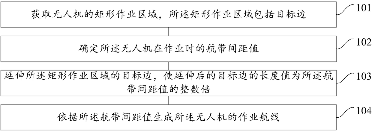
[0095] refer to figure 1 , which shows a flow chart of the steps of Embodiment 1 of a method for generating a drone route of the present application, which may specifically include the following steps:

[0096] Step 101, obtaining a rectangular operating area of ​​the drone, the rectangular operating area including the target side;

[0097] Usually, before the UAV performs operations, it needs to first determine the operation area of ​​the UAV. The operating area of ​​the UAV may refer to the operating range of the UAV when performing operations such as surveying and mapping or plant protection, and the operating area may be an area of ​​any shape with a certain size. For example, rectangles, circles, ...


PUM


Abstract

The embodiment of the present application provides a method and a device for generating an unmanned aerial vehicle route. The method comprises the following steps of: acquiring a rectangular operationarea of the unmanned aerial vehicle, wherein the rectangular operation area comprises a target edge; determining an air strip space value of the unmanned aerial vehicle during operation; extending the target edge of the rectangular operation area such that a length value of the extended target edge is an integer multiple of the air strip space value; and generating an operation route of the unmanned aerial vehicle according to the air strip space value, so that the unmanned aerial vehicle can perform operations such as surveying and mapping according to the operation route. According to the method and the device for generating the unmanned aerial vehicle route, the problems that the aerial survey data of the unmanned aerial vehicle in the prior art in agricultural surveying and mapping service and surveying and mapping related operation is prone to abnormal problems such as loopholes and missing data during later data processing are solved.

Description

technical field [0001] The present application relates to the technical field of drones, in particular to a method for generating a drone route and a device for generating a drone route. Background technique [0002] Unmanned aircraft, referred to as Unmanned Aerial Vehicle (UAV), is an unmanned aircraft that is controlled by radio remote control equipment and its own program control device. UAVs have a wide range of uses and are often used in industries such as agricultural plant protection, agricultural surveying and mapping, emergency rescue and disaster relief, and video shooting. [0003] Taking the agricultural surveying and mapping UAV as an example, when the UAV is performing agricultural surveying and mapping operations, it first needs to calculate the flight zone spacing of the surveying and mapping area according to the overlap rate and resolution used in the surveying and mapping, and then according to the flight belt spacing and the surveying and mapping area W...

Claims


Application Information

Patent Timeline
Patent Type & Authority Applications(China)
IPC IPC(8): G05D1/10
CPCG05D1/101
Inventor 吴奔黄泽坛
Owner GUANGZHOU XAIRCRAFT TECH CO LTD
Why Eureka
Try Eureka