UAV flight route planning method, device, system and intelligent terminal

A technology of flight routes and drones, applied in traffic control systems, control/regulation systems, vehicle position/route/height control, etc., can solve the problems of high safety hazards, poor operation effects, undulating terrain and ridges of drones Problems such as inconsistencies in directions can be solved to achieve the effect of improving operational safety, high accuracy, and ensuring heading accuracy

Active Publication Date: 2020-05-22
深圳凌悦航空科技有限公司
View PDF12 Cites 0 Cited by
  • Summary
  • Abstract
  • Description
  • Claims
  • Application Information

AI Technical Summary

Problems solved by technology

[0005] In view of this, the embodiment of the present invention provides a UAV flight route planning method, device, system, and terminal to solve the problem of undulating terrain or sparse and irregular ridge spacing of the operating object. The problem that the flight route obtained by the flight route planning method does not match the terrain undulations and ridges, and the resulting problems of high safety hazards and poor operation results of drones

Method used


Image

  • UAV flight route planning method, device, system and intelligent terminal
  • UAV flight route planning method, device, system and intelligent terminal
  • UAV flight route planning method, device, system and intelligent terminal

Examples


Embodiment 1

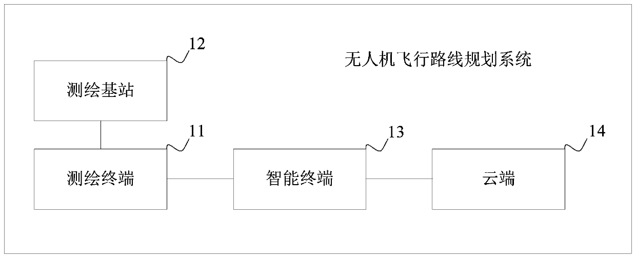
[0058] See figure 1 , is a schematic block diagram of the system architecture of a UAV flight route planning system provided by an embodiment of the present invention, the system may include a surveying and mapping terminal 11, a surveying and mapping base station 12, and an intelligent terminal 13; the surveying and mapping terminal 11, the surveying and mapping base station 12, and the intelligent terminal 13 communication connection;

[0059] The surveying and mapping terminal is used to measure the waypoint information of the waypoint, and send the waypoint information to the smart terminal;

[0060] The intelligent terminal is used to obtain waypoint information; among them, the waypoint is based on the terrain undulations of the plot to be operated, according to the preset dot rule, and according to the direction of the object to be operated on the plot to be operated. Point information, display each waypoint in the corresponding position of the plot map to be operated;...

Embodiment 2

[0068] After introducing the system architecture of the UAV flight route planning system, the specific planning process of the UAV flight route planning method provided by the embodiment of the present invention will be described in detail below.

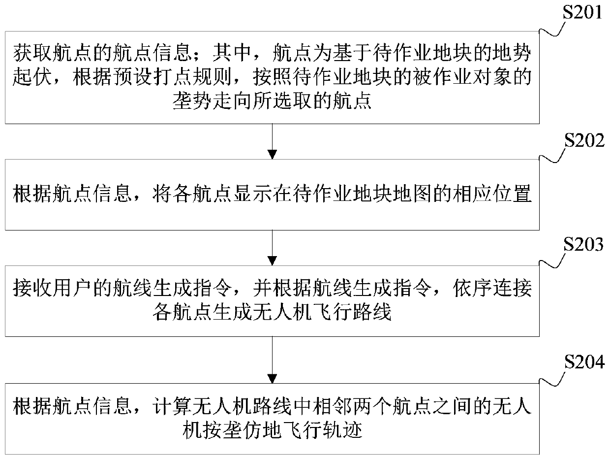
[0069] See figure 2 , is a schematic flow chart of a method for planning a UAV flight route provided by an embodiment of the present invention, the method may include the following steps:

[0070] Step 201. Obtain the waypoint information of the waypoint; wherein, the waypoint is a waypoint selected based on the terrain undulation of the plot to be operated, according to the preset dot rule, and according to the trend of the object to be operated on the plot to be operated.

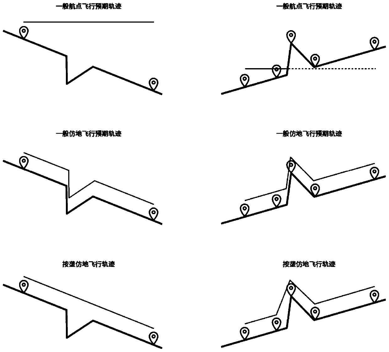
[0071] It should be noted that the above-mentioned plots to be operated may be plots with large terrain fluctuations, such as mountains, slopes, etc., or plots with small terrain fluctuations, such as plains. In comparison, although the technical solutions pr...

Embodiment 3

[0091] See Figure 4 , which is another schematic flow diagram of the UAV flight route planning method provided by the embodiment of the present invention, the method may include the following steps:

[0092] Step 401 , acquiring waypoint information of the waypoint.

[0093] It should be noted that this step is the same as the above-mentioned step 201, and for the corresponding introduction, refer to the corresponding content above, and details are not repeated here.

[0094] Step 402 , according to the waypoint information, display each waypoint at the corresponding position on the map of the plot to be operated. This step is the same as the above-mentioned step 202, and for the corresponding introduction, refer to the corresponding content above, and details are not repeated here.

[0095] Step 403 , displaying waypoint information at a preset interface position; receiving a waypoint recording instruction from a user; and recording the waypoint according to the waypoint r...


PUM


Abstract

The embodiment of the invention discloses an unmanned aerial vehicle flight route planning method, device and system, and an intelligent terminal. The unmanned aerial vehicle flight route planning method comprises the steps that waypoint information of waypoints is obtained; according to the waypoint information, all the waypoints are displayed at the corresponding positions of a map of a to-be-operated land block and recorded; an airline generating instruction of a user is received, and according to the airline generating instruction, all the waypoints are sequentially connected to generate an unmanned aerial vehicle flight route; and according to the waypoint information, an unmanned aerial vehicle by-ridge-trend terrain-imitated flight trajectory between every two waypoints in the unmanned aerial vehicle route is calculated. According to the unmanned aerial vehicle flight route planning method, device and system, and the intelligent terminal, the operation safety, accuracy and operation effect of an unmanned aerial vehicle under the environment of large terrain fluctuation can be improved.

Description

technical field [0001] The invention belongs to the technical field of unmanned aerial vehicles, and in particular relates to a method, device, system and intelligent terminal for planning flight routes of unmanned aerial vehicles. Background technique [0002] With the continuous development of drone technology, the application fields of drones are also becoming wider and wider. [0003] The diverse application fields of UAVs lead to complex and changeable operational terrains for UAVs. For example, in the field of plant protection, plant protection UAVs often need to operate in areas with large ups and downs such as mountains and slopes. It is particularly important to plan the flight route reasonably when the UAV is operating in these terrains with large ups and downs. [0004] At present, UAV flight routes are generally automatically generated according to the boundary points of the operation plots, that is, the boundary points of the operation plots are recorded throu...

Claims


Application Information

Patent Timeline
Patent Type & Authority Patents(China)
IPC IPC(8): G08G5/00G05D1/10G05D1/04
CPCG05D1/042G05D1/101G08G5/0069
Inventor 赵自超闫小乐万耿栋陈星宏骆艺特
Owner 深圳凌悦航空科技有限公司
Why Eureka
Try Eureka