A method for measuring the spatial position of traffic signs based on two-dimensional images

A traffic sign and spatial location technology, applied in image analysis, image data processing, complex mathematical operations, etc., can solve the problems of high cost of measuring equipment, low data processing efficiency, and heavy data collection workload

Active Publication Date: 2019-01-04
北京领骏科技有限公司
View PDF4 Cites 11 Cited by
  • Summary
  • Abstract
  • Description
  • Claims
  • Application Information

AI Technical Summary

Problems solved by technology

It mainly solves the problems of high cost of measuring equipment in the current existing methods, the need for accurate calibration of th

Method used


Image

  • A method for measuring the spatial position of traffic signs based on two-dimensional images
  • A method for measuring the spatial position of traffic signs based on two-dimensional images
  • A method for measuring the spatial position of traffic signs based on two-dimensional images

Examples


Embodiment Construction

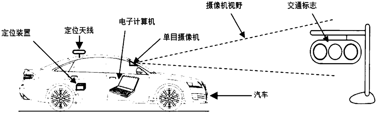
[0064] The traffic sign targeted by this method can be any place that can be captured by the camera.

[0065] 1.1 Measuring device

[0066] Such as figure 1 As shown, the device for measuring the spatial position of a traffic sign proposed by the present invention includes:

[0067] a. One vehicle that can run normally on the road (measurement vehicle, no special requirements).

[0068] b. One ordinary monocular camera / camera, which can be installed at any position on the car, and can photograph the external environment to generate two-dimensional digital images. There is no requirement for the installation position of the camera. You can shoot forward or sideways. The device can be installed anywhere in a, such as the inside of the front windshield, or the roof of a car. But it needs to be connected to the body stably. The user can flexibly choose the camera installation location according to the location characteristics of the target to be tested. For example, when measuring a ...


PUM


Abstract

The invention provides a method for measuring the spatial position of a traffic sign based on a two-dimensional image. The absolute position of a target traffic sign center in a three-dimensional space can be obtained by collecting measurement data of the traffic sign, labeling the measured original image data, and performing data post-processing combined with positioning data. Traffic signs on the road are measured using conventional monocular cameras/cameras installed in the vehicle interior and high-precision positioning equipment to obtain the location information of traffic signs in three-dimensional space.

Description

Technical field [0001] The invention relates to a method for measuring traffic signs, in particular to a method for measuring the spatial position of traffic signs based on two-dimensional images. Background technique [0002] In some surveying and mapping tasks, such as the collection and drawing of high-precision maps for automatic driving, it is necessary to measure the three-dimensional spatial position of traffic signs. These traffic signs include road signs, speed limit signs, prohibition signs, traffic lights, etc. The three-dimensional space position can be expressed as longitude, latitude, and altitude coordinates (represented by the three quantities of longitude, latitude, and altitude), or as rectangular coordinates after the spherical projection of the earth (for example, UTM coordinate system, using x, y, z three In terms of quantity, they respectively represent the offset distance of a certain spatial position in the true east, true north, and altitude). When the ...

Claims


Application Information

Patent Timeline
IPC IPC(8): G06T7/70G06F17/16
CPCG06F17/16G06T7/70
Inventor 杨文利何家瑞
Owner 北京领骏科技有限公司
Why Eureka
Try Eureka