Low-orbit satellite constellation and C waveband combined navigation signal based satellite navigation system and method

A satellite navigation system and integrated navigation technology, applied in satellite radio beacon positioning systems, radio wave measurement systems, instruments, etc., can solve problems such as limited safety, limited service range, limited integrity and usability, and achieve service Wide-ranging, usable effects

Active Publication Date: 2019-03-05
TSINGHUA UNIV
View PDF9 Cites 1 Cited by
  • Summary
  • Abstract
  • Description
  • Claims
  • Application Information

AI Technical Summary

Problems solved by technology

[0004] However, determined by the GNSS technical system, GNSS signals have inherent limitations and vulnerabilities, which are mainly reflected in the following aspects: 1) The service range is limited
Satellite navigation cannot provide high-precision and high-reliability PNT services in environments with physical occlusions such as indoors, mountains, valleys, and dense urban areas, as well as at the north and south poles; 2) limited security
GNSS signals are very sensitive to electromagnetic interference, and cannot provide safe and reliable PNT services in complex electromagnetic environments such as unintentional or intentional interference and spoofing; 3) Integrity and availability capabilities are limited
Due to factors such as positioning accuracy, satellite geometric distribution, and susceptibility to interference, it is difficult to meet the high integrity and availability requirements of life safety services represented by aviation applications such as aircraft autonomous landing and landing

Method used


Image

  • Low-orbit satellite constellation and C waveband combined navigation signal based satellite navigation system and method
  • Low-orbit satellite constellation and C waveband combined navigation signal based satellite navigation system and method
  • Low-orbit satellite constellation and C waveband combined navigation signal based satellite navigation system and method

Examples


Embodiment Construction

[0016] The satellite navigation system and method based on the low-orbit satellite constellation and the C-band joint navigation signal disclosed in the present application will be described in detail below with reference to the accompanying drawings. For the sake of brevity, in the description of the various embodiments of the present application, the same or similar devices use the same or similar reference numerals.

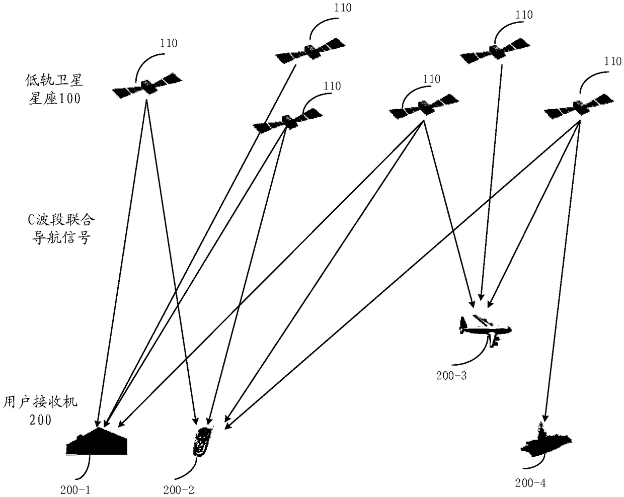
[0017] figure 1 An embodiment of a satellite navigation system based on a low-orbit satellite constellation and a C-band joint navigation signal according to the present application is shown. As shown in the figure, a satellite navigation system 10 according to this embodiment includes a low-orbit satellite constellation 100 and a user receiver 200 . The low-orbit satellite constellation 100 provides a C-band joint navigation signal to the user receiver 200 based on the C-band for positioning and navigation.

[0018] The low-orbit satellite constellation 100...


PUM


Abstract

The invention provides a low-orbit satellite constellation and C waveband combined navigation signal based satellite navigation system and method. A low-orbit satellite constellation provides a C waveband combined navigation signal to a user receiver for positioning and navigation. The system and method are wider in service range and higher in availability.

Description

technical field [0001] The present application relates to satellite navigation technology, in particular to satellite navigation systems and methods based on low-orbit satellite constellations and C-band joint navigation signals. Background technique [0002] Time and space information is the most basic information resource to promote military transformation, economic development and scientific and technological progress, and positioning, navigation and timing (PNT) is the most important and effective application of time and space information. It plays an indispensable role in scientific research. [0003] The global navigation satellite system (GNSS) represented by GPS in the United States, GLONASS in Russia, Galileo in Europe and BDS in China can provide all kinds of users around the world with all-weather and all-time PNT services under a unified time-space framework, and has become a global The key information infrastructure of GNSS has been widely and deeply applied, s...

Claims


Application Information

Patent Timeline
IPC IPC(8): G01S19/01G01S19/35G01S19/37
CPCG01S19/01G01S19/35G01S19/37
Inventor 马天翊陆明泉崔晓伟姚铮李洪赵思浩
Owner TSINGHUA UNIV
Why Eureka
Try Eureka