
Efficient monitoring method for multi-ship collision risk in sea area

A technology based on the degree of danger and sea area, applied in ship traffic control, instruments, character and pattern recognition, etc., can solve the problems of complex models, many parameters, and large amount of calculation, and achieve efficient monitoring, save calculation time, and realize real-time calculation Effect

Inactive Publication Date: 2019-03-08
TIANJIN UNIV
View PDF3 Cites 8 Cited by
  • Summary
  • Abstract
  • Description
  • Claims
  • Application Information

AI Technical Summary

Problems solved by technology

If this method is used, it is necessary to perform a calculation for all ships in the sea area, and the calculation amount is large, and the calculation model of many ship collision risk itself takes into account many parameters, and the model is more complicated

Method used


Image

  • Efficient monitoring method for multi-ship collision risk in sea area
  • Efficient monitoring method for multi-ship collision risk in sea area

Examples


Embodiment Construction

[0021] In order to make the purpose, technical solution and beneficial effects of the present invention more clear, the present invention will be further described in detail below in conjunction with the accompanying drawings.

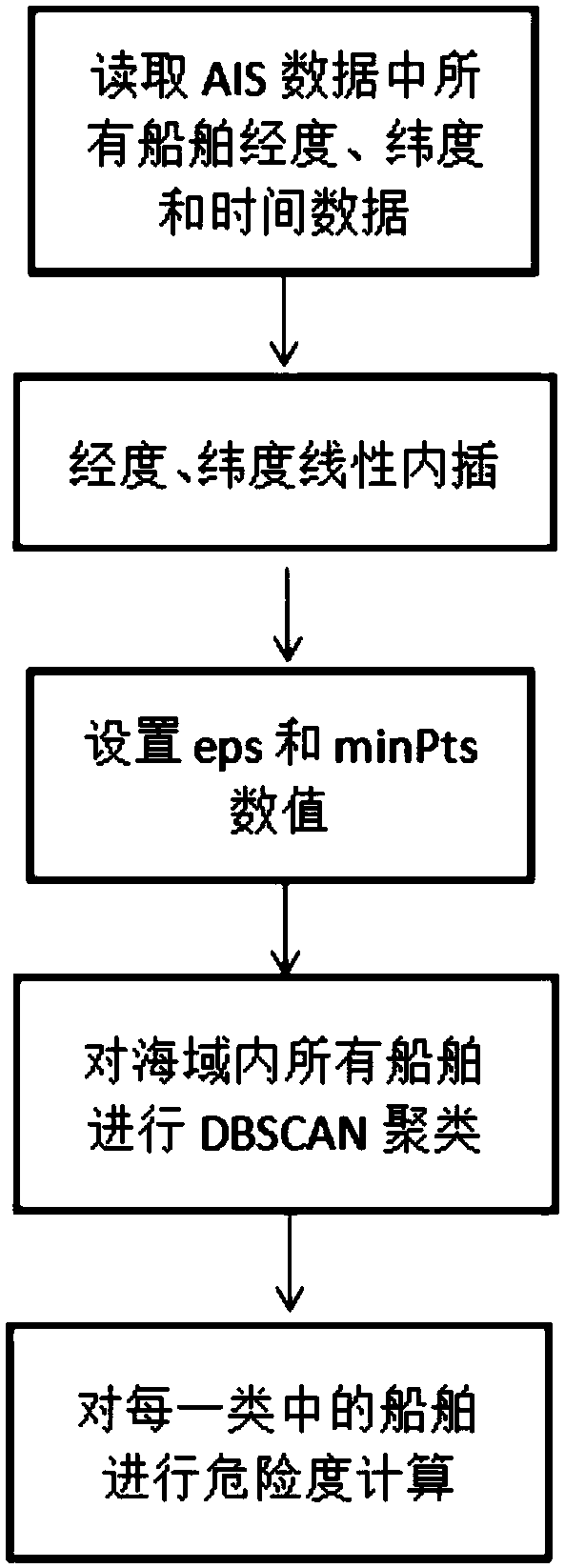
[0022] The efficient monitoring method of multi-vessel collision risk in the sea area of ​​the present invention, such as figure 1 As shown, it specifically includes the following steps:

[0023] The first step is to read the real-time AIS data (including longitude, latitude and time data) of all ships in the monitoring sea area. Since the AIS data of all ships are not released at the same time, the longitude and latitude coordinates of the ships are linearly interpolated first, and each The ship's position information is synchronized to the same point in time.

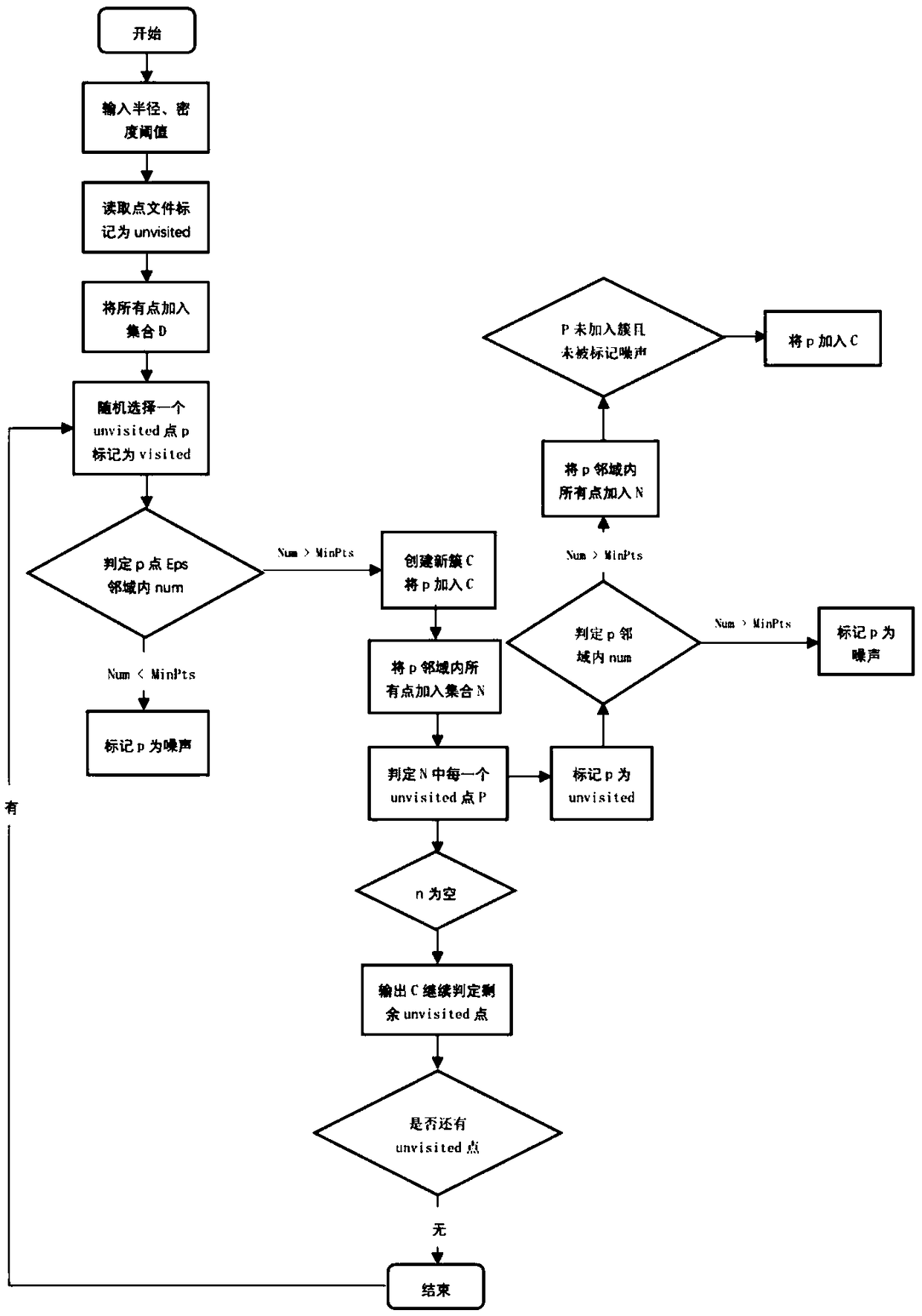
[0024] In the second step, the scanning radius eps of DBSCAN is set according to the monitoring requirements of ship collision risk, and the minimum number of included points minPts is set to...


PUM


Abstract

The invention discloses an efficient monitoring method for the multi-ship collision risk in the sea area. The method comprises steps that instantaneous AIS data of all the ships in the monitored sea area are read, latitude and longitude coordinates of the ships are linearly interpolated, the position information of each ship is synchronized to the same time point; a scanning radius of DBSCAN is set according to monitoring requirements of the ship collision risk, and the minimum inclusion point number is set to be 2; DBSCAN clustering calculation is performed for all the ships in the sea area,and the ships in the sea area are clustered according to spatial distribution; and the multi-ship collision risk is calculated for each ship in the cluster generated through clustering. The method isadvantaged in that the total calculation of the collision risk of all the ships in the sea area can be reduced, the total calculation time is saved, and real-time calculation of the collision risk isrealized.

Description

technical field [0001] The invention relates to the field of marine traffic, and more specifically, relates to an efficient monitoring method for the risk of multi-vessel collision in a sea area. Background technique [0002] With the development of economic globalization, maritime transportation plays an increasingly important role in international trade. The rapidly increasing demand for sea freight has led to the development of large-scale and high-speed ships. The number of ships sailing at sea has continued to increase, and the sea traffic in ports, inland waters, and bays has become more and more intensive. There is a high probability that a ship will encounter multiple ships at the same time during navigation, which greatly increases the hidden danger of ship collision. Although the Vessel Traffic Service Monitoring System (VTS) has been established in my country's coastal waters at this stage, the system is mainly used to display the current position of ships in the...

Claims


Application Information

Patent Timeline
Patent Type & Authority Applications(China)
IPC IPC(8): G08G3/02G06K9/62
CPCG08G3/02G06F18/2321
Inventor 张安民欧阳知雨张豪宁一伟刘禹刘帅刘荣霞侯泽北
Owner TIANJIN UNIV
Learn More