
Road pavement elevation detection system and road pavement elevation detection method

A detection system and detection method technology, applied in the direction of height/level measurement, measuring device, measuring instrument, etc., can solve the problem of large error in road elevation data, etc., and achieve the effect of low cost, simple operation procedure and easy operation

Inactive Publication Date: 2019-03-22
JIANGSU UNIV
View PDF5 Cites 3 Cited by
  • Summary
  • Abstract
  • Description
  • Claims
  • Application Information

AI Technical Summary

Problems solved by technology

The laser profiler is generally towed by a motor vehicle, and it is required to maintain a high speed and move forward at a constant speed as much as possible to maintain good accuracy. In low-speed road sections or traffic light intersections, the road elevation data that the instrument cannot collect has a large error

Method used


Image

  • Road pavement elevation detection system and road pavement elevation detection method
  • Road pavement elevation detection system and road pavement elevation detection method
  • Road pavement elevation detection system and road pavement elevation detection method

Examples


Embodiment Construction

[0029] In order to make the object, technical solution and advantages of the present invention clearer, the present invention will be further described in detail below in conjunction with the accompanying drawings and embodiments. It should be understood that the specific embodiments described here are only used to explain the present invention, not to limit the present invention.

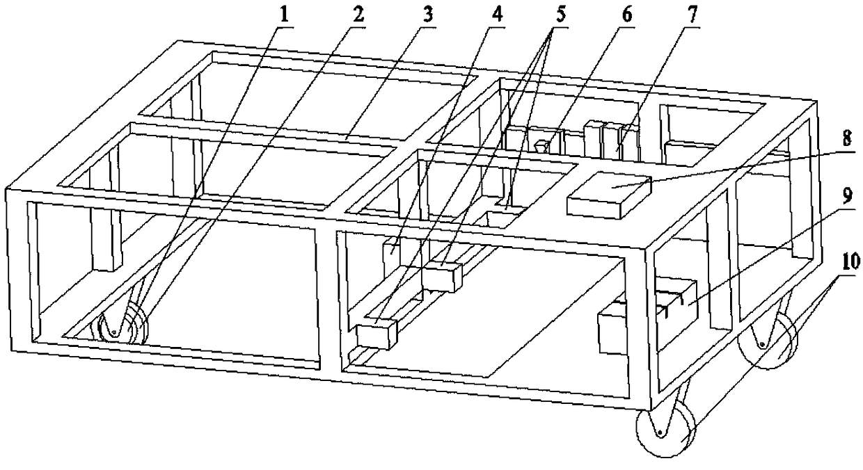
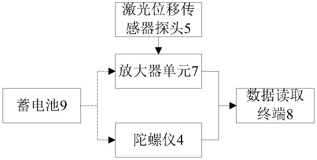
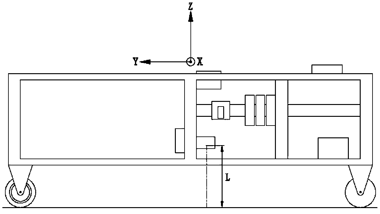
[0030] Such as figure 1 As shown, a road elevation detection system includes a car 3, a gyroscope 4, a laser displacement sensor probe 5, an amplifier unit 7, a data reading terminal 8 and a battery 9, and the hub motor 1 is installed on the front wheel 2 of the car 3, The trolley 3 is driven, and the front wheel 2 is a steering wheel;

[0031] The gyroscope 4 is installed at the geometric center of the car 3 for detecting the posture of the car 3 during driving, and the gyroscope 4 is connected to the data reading terminal 8 through a converter;

[0032] There are three displacement sensor probe...


PUM


Abstract

The invention discloses a road pavement elevation detection system and a road pavement elevation detection method. The road pavement elevation detection system consists of a laser displacement sensor,a gyroscope, a data reading terminal and the like. The road pavement elevation data is collected to establish a three-dimensional virtual road pavement model and evaluate the road pavement conditions; a trolley is driven by front wheels of the trolley to drive on the road pavement; the system starts to work, the laser displacement sensor is used for collecting the road pavement elevation data inreal time, and the gyroscope is used for detecting the attitudes of the trolley; when the wheels of the trolley pass through the convex or concave part of the road pavement, the road pavement elevation data measured by the laser displacement sensor produces measurement error; the attitudes of the trolley are detected by the gyroscope, and a correlation model between the attitudes of the trolley and the measurement error of the laser displacement sensor is established; finally, the data reading terminal is used for correcting the measurement error of the laser displacement sensor, and the accurate road pavement elevation data is calculated. By adoption of the system for accurately measuring the road pavement elevation data, the road pavement elevation data can be accurately measured, so that the cost and labor can be reduced.

Description

technical field [0001] The invention belongs to the field of measuring equipment, and in particular relates to a road surface elevation detection system and a detection method thereof. Background technique [0002] Pavement elevation data can provide a data basis for establishing a three-dimensional virtual pavement model and evaluating pavement conditions. Vehicle road tests require a lot of manpower and financial resources, and the establishment of virtual road surface simulation models for road tests can save a lot of cost; the International Roughness Index (IRI), as an evaluation index for road surface roughness, is also calculated from the road surface elevation . The traditional measurement methods of road elevation are leveling method and triangular elevation measurement. At present, the most widely used road elevation measuring instruments are level and total station. The measurement speed of the station instrument is faster, but the accuracy is lower, and the cost...

Claims


Application Information

Patent Timeline
Patent Type & Authority Applications(China)
IPC IPC(8): G01C5/00G01C15/00G01C21/18
CPCG01C5/00G01C15/00G01C21/18
Inventor 陆颖张玉辰
Owner JIANGSU UNIV
Learn More