A node-based geographic route finding map identification method

A marking and map technology, applied in geographic information databases, maps/plans/charts, instruments, etc., can solve the problem of finer-grained management without considering river sections and river sections, and cannot express and color multi-level rivers, river sections and data management issues

Active Publication Date: 2019-03-29
重庆英卡电子有限公司
View PDF7 Cites 1 Cited by
  • Summary
  • Abstract
  • Description
  • Claims
  • Application Information

AI Technical Summary

Problems solved by technology

[0003] Defects of the existing electronic map: the existing electronic map directly loads and displays the entire river at one time, without considering finer-grained issues such as river sections and river section

Method used


Image

  • A node-based geographic route finding map identification method
  • A node-based geographic route finding map identification method
  • A node-based geographic route finding map identification method

Examples


Embodiment Construction

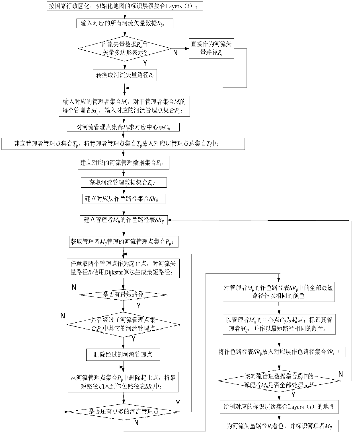
[0059] The present invention will be described in further detail below in conjunction with the accompanying drawings and specific embodiments.

[0060] Such as Figure 1-Figure 4 As shown, a node-based geographic pathfinding map identification method includes a building method and a display method, wherein the building method includes the following steps:

[0061] Including the establishment method and the display method, wherein the establishment method includes the following steps:

[0062] Step A: According to the administrative division of the country, initialize the identification level Layers(i) of the map; i=5~22;

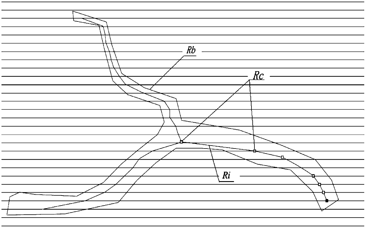
[0063] Step B: Input all river vector data R of the corresponding identification level Layers(i) b , converting it into a river vector path R i ;

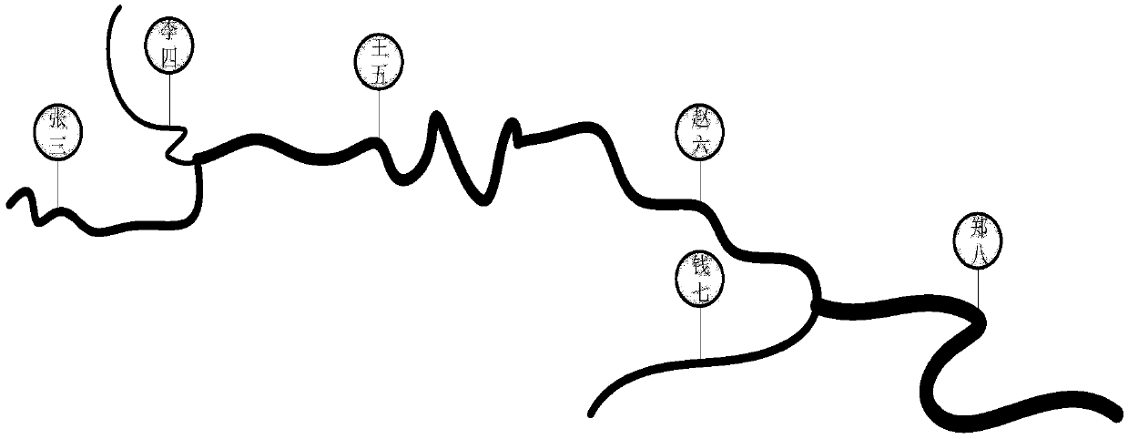
[0064] Step C: Input the manager set M of the corresponding identification level Layers(i) i , the set of managers M i There are m managers M ij , j=1~m, for the manager set M i Each manager M of ij , in...


PUM


Abstract

The invention discloses a node-based geographic route finding map identification method, comprising a establishing method and a displaying method. The establishing method comprises: inputting all river vector data Rb corresponding to the identification level Layers (i) and converting the input data Rb into a river vector path Ri; Inputting a set of managers Mi of the identification hierarchy Layers (i), and inputting a corresponding set of river management points Pij for each manager Mij of the set of managers Mi; Finding a corresponding center point Cij for the river management point set Pij;Establishing a management point set Tij of a manager, and establishing a river management data set Ei identifying a hierarchy of Layers (i); Displaying a river management data set Ei generated by themethod according to the establishment method; Generating, color and display the managed reach of the manager. The invention uses the multi-level node tree and the shortest path to generate the riversection, thereby solving the map display problem of the river section management from the generation and expression mode, and facilitating the administrator to better manage the river.

Description

technical field [0001] The invention belongs to the technical field of electronic maps, and in particular relates to a node-based geographical routing map identification method. Background technique [0002] Rivers in traditional electronic maps usually use vector (Shp / KM, etc.) or bitmap slices to represent and display rivers. Among them, vector polygons and vector line segments are the main representation methods, and their advantages are that they support stepless zooming of maps and are easy to edit. But the vector polygon / line segment is a whole, and it needs to be loaded at one time and displayed as a whole. It is difficult to represent the different reaches of a river and the refinement of the jurisdiction area. [0003] Defects of the existing electronic map: the existing electronic map directly loads and displays the entire river at one time, without considering finer-grained issues such as river sections and river section management, and cannot express and color ...

Claims


Application Information

Patent Timeline
IPC IPC(8): G06F16/29G09B29/00
CPCG09B29/005
Inventor 唐灿曹晓莉封强江朝元李靖刘崇科杨强彭鹏马吉刚陈露
Owner 重庆英卡电子有限公司
Why Eureka
Try Eureka