A method for post-disaster damage assessment of buildings by using unmanned aerial vehicles

A technology for unmanned aerial vehicles and buildings, which is applied in image data processing, instruments, non-electric variable control, etc., and can solve the problems of long disaster assessment period

Inactive Publication Date: 2019-03-29
UNIV OF SHANGHAI FOR SCI & TECH
View PDF4 Cites 25 Cited by
  • Summary
  • Abstract
  • Description
  • Claims
  • Application Information

AI Technical Summary

Problems solved by technology

Moreover, there is a shortcoming of too long assessment period

Method used


Image

  • A method for post-disaster damage assessment of buildings by using unmanned aerial vehicles
  • A method for post-disaster damage assessment of buildings by using unmanned aerial vehicles
  • A method for post-disaster damage assessment of buildings by using unmanned aerial vehicles

Examples


Embodiment Construction

[0029] The following describes several preferred embodiments of the present invention with reference to the accompanying drawings, so as to make the technical content clearer and easier to understand. The present invention can be embodied in many different forms of embodiments, and the protection scope of the present invention is not limited to the embodiments mentioned herein.

[0030] In the drawings, components with the same structure are denoted by the same numerals, and components with similar structures or functions are denoted by similar numerals. The size and thickness of each component shown in the drawings are shown arbitrarily, and the present invention does not limit the size and thickness of each component. In order to make the illustration clearer, the thickness of parts is appropriately exaggerated in some places in the drawings.

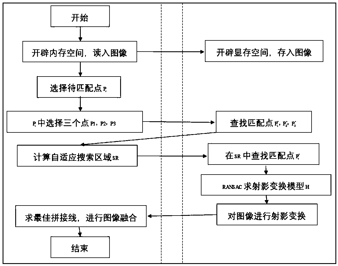
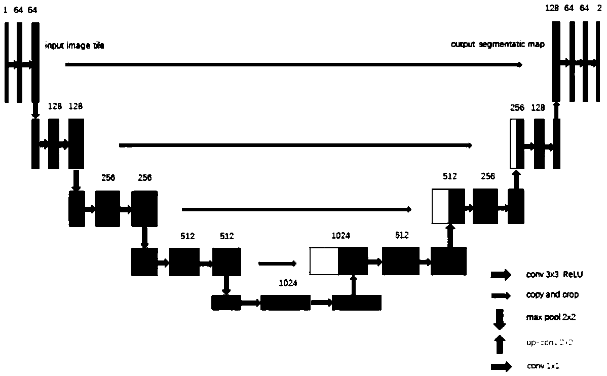
[0031] The functional division of multi-UAV mission planning mainly includes multi-UAV collaborative path planning and multi-UAV ef...


PUM


Abstract

The invention discloses a method for post-disaster damage assessment of buildings by using unmanned aerial vehicles, and relates to the field of disaster assessment. Multiple unmanned aerial vehicles(UAVs) are used to shoot the images of the disaster area, and then TIFF format remote sensing images of the disaster area are quickly constructed on a GPU server by using the photographed high-definition images transmitted from the UAVs. the neural network image segmentation model is used to extract the intact houses from the remote sensing images and compare them with the remote sensing images before the disaster, the block is taken as the unit to record the damaged data and corresponding GPS coordinates, and the geographic coordinates polar spherical projection is used to draw the distribution map of the damaged houses on the map of the disaster area. The invention can quickly evaluate the disaster situation, and the detection result has high credibility.

Description

technical field [0001] The invention relates to the field of disaster assessment, in particular to a method for evaluating damaged buildings after a disaster by using an unmanned aerial vehicle. Background technique [0002] Disaster assessment is the judgment and estimation of disaster situation. The mainstream means of disaster assessment in modern society is through satellite remote sensing images. Moreover, there is a shortcoming of too long evaluation period for disaster assessment through satellite remote sensing images. After the disaster occurs, people hope to provide a reference for the next dispatch of personnel and materials for earthquake relief by quickly assessing the disaster situation. [0003] Therefore, those skilled in the art are devoting themselves to developing a new system that can quickly assess the disaster situation after the disaster occurs. Contents of the invention [0004] In view of the above-mentioned defects of the prior art, the technica...

Claims


Application Information

Patent Timeline
IPC IPC(8): G06T7/136G06T7/11G06T3/40G05D1/10
CPCG05D1/104G06T3/4038G06T2207/10032G06T2207/20081G06T7/11G06T7/136
Inventor 琚波波邬春学
Owner UNIV OF SHANGHAI FOR SCI & TECH
Why Eureka
Try Eureka