Seawall settlement safety monitoring method based on GIS (Geographic Information System) technology

A safety monitoring and seawall technology, which is applied in measuring devices, surveying and navigation, height/horizontal measurement, etc., can solve the problems of wide distribution of monitoring points, low precision, and long distance, so as to reduce labor intensity, improve automation level, The effect of guaranteeing authenticity

Inactive Publication Date: 2019-04-02
浙江海岸岩土工程技术有限公司
View PDF4 Cites 0 Cited by
  • Summary
  • Abstract
  • Description
  • Claims
  • Application Information

AI Technical Summary

Problems solved by technology

[0003] Therefore, ensuring the safe and stable operation of seawall buildings is also an important barrier to protect the city from the hazards of tides. It is necessary to strictly monitor the settlement and deformation of seawall structures, and scientifically and reasonably predict their post-construction settlement. The settlement is mostly based on manual measurement methods. Monitoring points The wide distribution and long distance make manual measurement difficult and low precision, and real-time monitoring cannot be carried out due to the limitation of the measurement cycle

Method used


Image

  • Seawall settlement safety monitoring method based on GIS (Geographic Information System) technology

Examples


Embodiment Construction

[0023] In order to make the purpose, technical solutions and advantages of the present application clearer, the technical solutions in the embodiments will be clearly and completely described below in conjunction with the accompanying drawings in the embodiments,

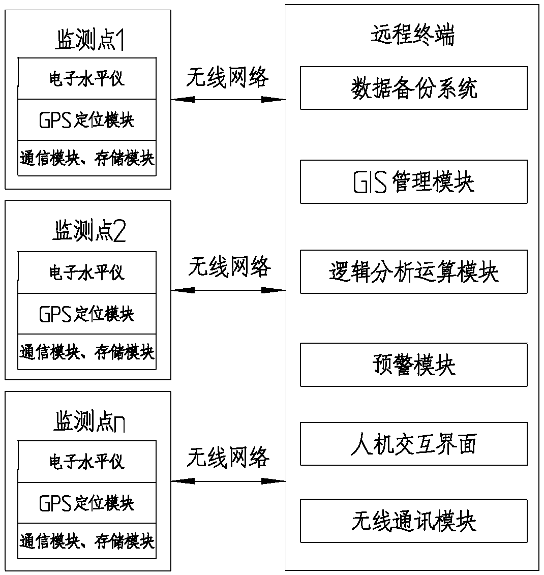
[0024] A seawall settlement safety monitoring method based on GIS technology, characterized in that: comprising the following steps

[0025] S1: Data collection and processing:

[0026] A, electronic level is set at each monitoring point of seawall, and described electronic level connects GPS module and communication module;

[0027] B. The electronic level collects data from the seawall in real time and saves the data in the storage module;

[0028] C. Data upload, upload the measurement data to the remote terminal through the communication module, and the communication method can use GPRS;

[0029] S2: Data Management and Analysis:

[0030] Real-time management of settlement data through the developed web manag...


PUM


Abstract

The invention discloses a seawall settlement safety monitoring method based on a GIS technology. The method is characterized by comprising the following steps of: arranging electronic levels at each monitoring point in the seawall; collecting and storing data in the seawall in real time through the electronic levels; uploading the measured data to a remote terminal; and managing the settlement data in real time through a Web management system of a developed B / S architecture. The electronic level is connected to a GPS module and a communication module. The specific content of the real-time management of the settlement data comprises the following steps of: calculating the settlement amount; issuing warning information; analyzing and predicting the settlement, drawing a graph through the data analysis function of the system, and analyzing the measurement data of the monitoring points; using a prediction method to predict the settlement trend of the monitoring points for a period of timein the future; providing necessary data support for the settlement assessment; and obtaining the settlement data in the database through a monitoring point layer, and graphically marking the settlement amount, the accumulated settlement amount, and the sedimentation rate on the map.

Description

technical field [0001] The invention belongs to the technical field, and in particular relates to a method for monitoring safety of seawall settlement based on GIS technology. Background technique [0002] Seawalls are man-made tidal dams and important barriers along the southeast coast of China. Seawalls have a history of more than 2,000 years and are mainly distributed in Jiangsu and Zhejiang provinces. [0003] Therefore, ensuring the safe and stable operation of seawall buildings is also an important barrier to protect the city from the hazards of tides. It is necessary to strictly monitor the settlement and deformation of seawall structures, and scientifically and reasonably predict their post-construction settlement. The settlement is mostly based on manual measurement methods. Monitoring points The wide distribution and long distance make manual measurement difficult and low accuracy, and real-time monitoring cannot be carried out due to the limitation of the measure...

Claims


Application Information

Patent Timeline
IPC IPC(8): G01C5/00
CPCG01C5/00
Inventor 王拥文
Owner 浙江海岸岩土工程技术有限公司
Why Eureka
Try Eureka