Route planning method for autonomous vehicle based on vector map and grid map

A grid map and vector map technology, applied in vehicle position/route/altitude control, motor vehicles, transportation and packaging, etc., can solve the problems of large computational load, poor path planning accuracy, and high requirements for on-board sensors, to meet real-time requirements. performance and accuracy, the effect of reduced occupancy

Pending Publication Date: 2019-04-02
ECARX (HUBEI) TECHCO LTD
View PDF6 Cites 41 Cited by
  • Summary
  • Abstract
  • Description
  • Claims
  • Application Information

AI Technical Summary

Problems solved by technology

[0004] In the existing automatic driving path planning methods, the single use of global path planning or local motion path planning is used, which has a large amount of computation and takes up a lot of system resources, and the use of a single local motion path planning has high requirements for on-board sensors. Poor path planning accuracy

Method used


Image

  • Route planning method for autonomous vehicle based on vector map and grid map
  • Route planning method for autonomous vehicle based on vector map and grid map
  • Route planning method for autonomous vehicle based on vector map and grid map

Examples


Embodiment 1

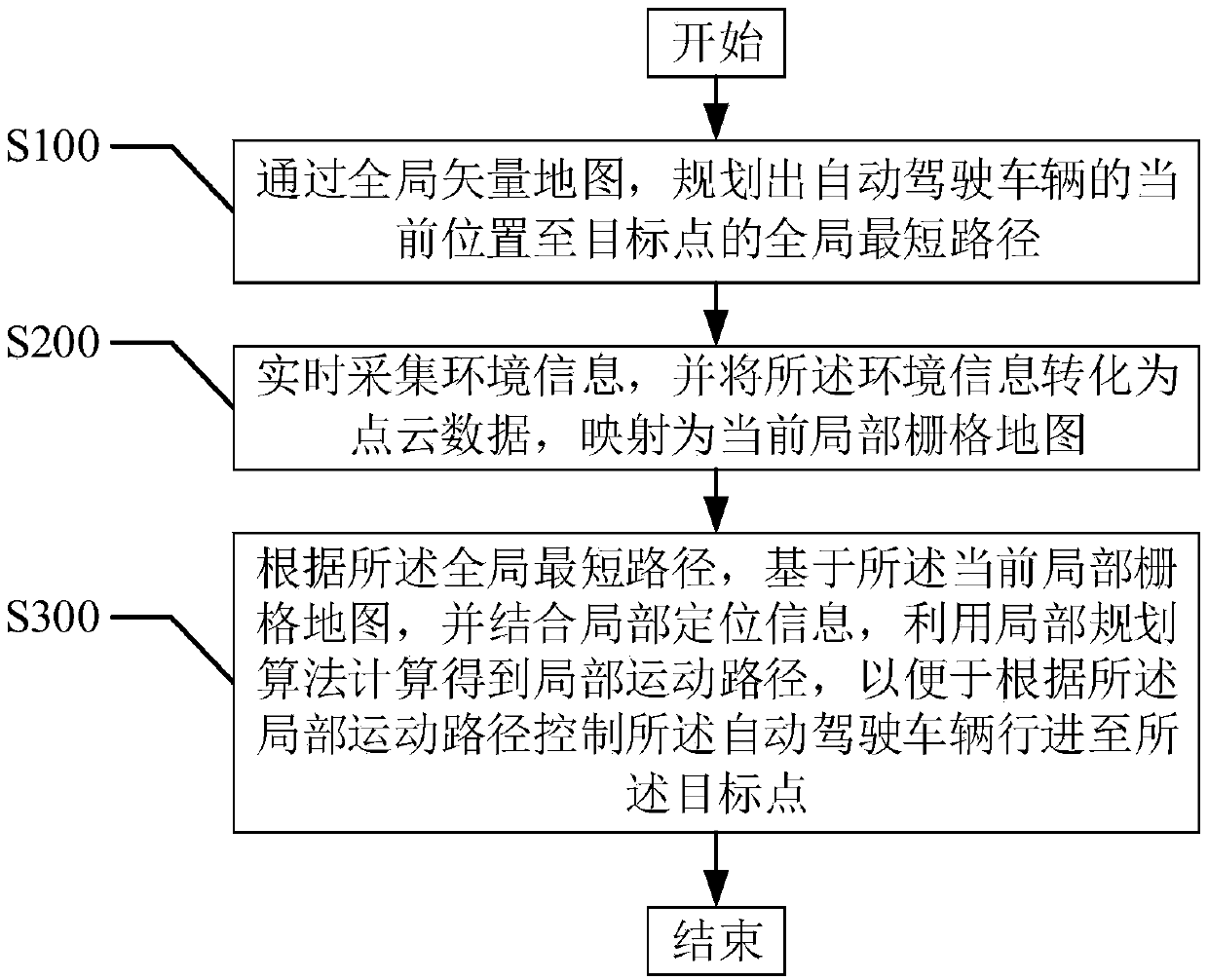
[0063] refer to figure 2 , the first embodiment of the present invention provides a path planning method for an autonomous vehicle based on a vector map and a grid map, including:

[0064] Step S100, planning out the global shortest path from the current position of the autonomous vehicle to the target point through the global vector map;

[0065] An autonomous vehicle, also known as a driverless car, a computer-driven car, or a wheeled mobile robot, is a kind of intelligent car that realizes unmanned driving through a computer system. In the 20th century, it has a history of several decades, and the beginning of the 21st century shows a trend of close to practical use.

[0066] The global vector map is a vector map within a certain range, for example, a vector map in a city area, or a vector map in a parking lot.

[0067] The starting point and focus of path planning are between the current position of the autonomous vehicle and the target point. The global shortest path ...

Embodiment 2

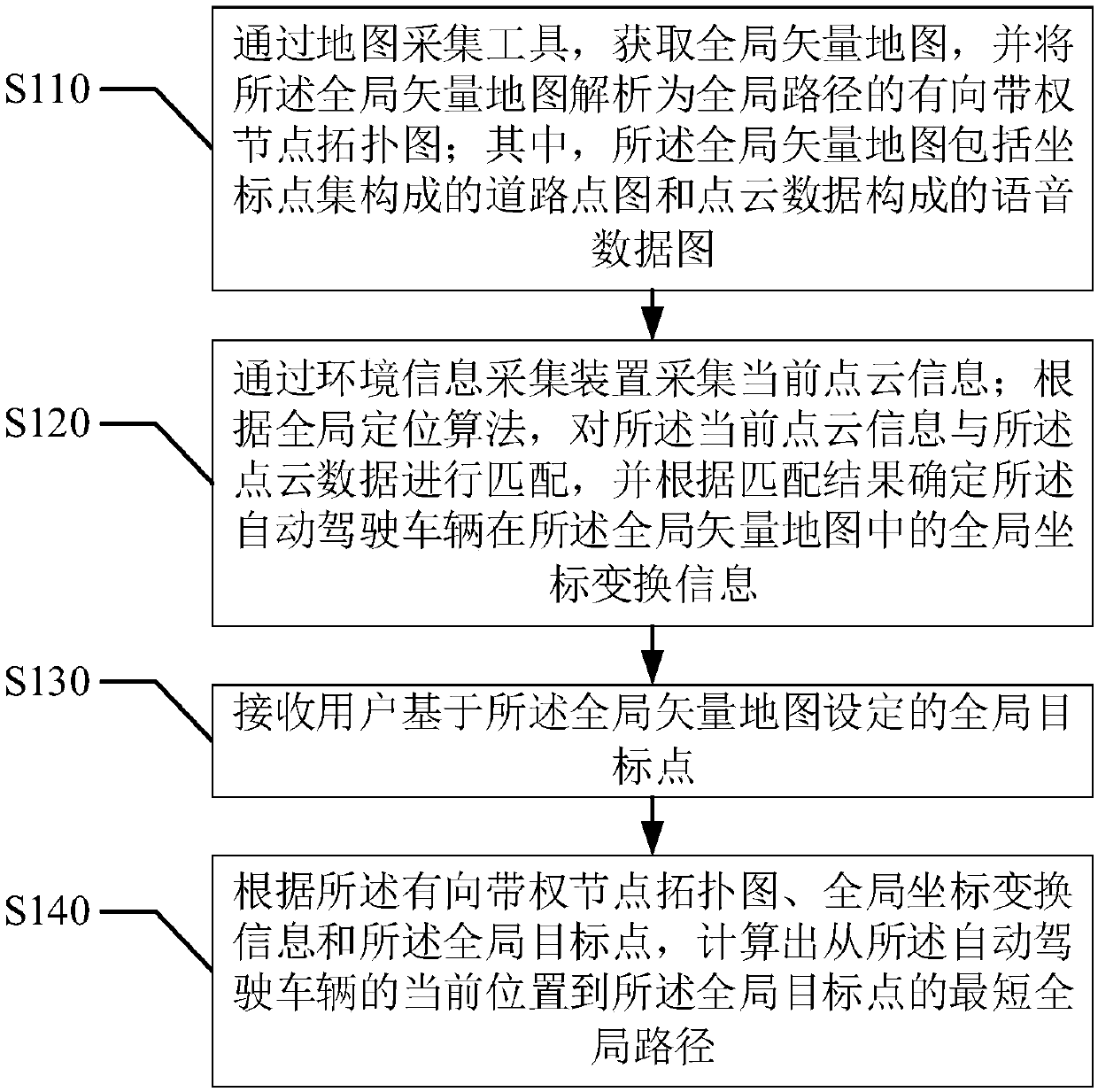
[0079] refer to Figure 3-4 , the second embodiment of the present invention provides a path planning method for an autonomous vehicle based on a vector map and a grid map, based on the above figure 2 In the illustrated first embodiment, the step S100, "planning the global shortest path from the current position of the autonomous vehicle to the target point through the global vector map" includes:

[0080] Step S110, obtain a global vector map through a map collection tool, and parse the global vector map into a directional weighted node topology map of a global path; wherein, the global vector map includes a road point map composed of a coordinate point set and a Voice data map composed of point cloud data;

[0081] Further, the step S110, "obtaining a global vector map, and parsing the global vector map into a directional weighted node topology map" includes:

[0082] Step S111, collecting and obtaining the global vector map;

[0083] Step S112, run the global map parser...

Embodiment 3

[0092] refer to Figure 5-8 , the third embodiment of the present invention provides a path planning method for an autonomous driving vehicle based on a vector map and a grid map, based on the above figure 2 In the first embodiment shown, the step S200, "collecting environmental information in real time, converting the environmental information into point cloud data, and mapping it to the current local grid map" includes:

[0093] Step S210, segment and fuse the current point cloud information collected by the environmental information collection device, and map the segmented and fused current point cloud information to a two-dimensional grid map to obtain a preliminary grid map ;

[0094] Step S220, based on the current point cloud information, obtain the current local grid map according to the preliminary grid map.

[0095] Further, the step S220, "acquiring the current local grid map according to the preliminary grid map based on the current point cloud information" incl...


PUM


Abstract

The invention provides a route planning method for an autonomous vehicle based on a vector map and a grid map. The route planning method comprises: planning a global shortest route of the current position of the autonomous vehicle to a target point through a global vector map; obtaining a current partial grid map of the current position of the autonomous vehicle; and according to the global shortest route, calculating a partial motion route based on the partial grid map, and controlling the autonomous vehicle to travel to the target point according to the partial motion path. According to theroute planning method for the autonomous vehicle based on the vector map and the grid map, the vector map is used as an environment model in the global route planning layer, and the grid map is used as an environment model in the partial motion route planning layer, that is, different maps are used as environment models in different planning layers, and at the same time, different types of planning algorithms are used, so that the real-time performance and accuracy of the algorithm under an actual scene are met at the same time, and the algorithm combining the vector map and the grid map greatly reduces the occupation of system operation resources.

Description

technical field [0001] The invention relates to the technical field of automatic driving, and more particularly, to a path planning method for automatic driving vehicles based on a vector map and a grid map. Background technique [0002] Autonomous driving is an important development direction of current intelligent transportation, and path planning technology is one of the core technologies of autonomous driving and the basis of intelligent vehicle navigation and control. [0003] The path planning technology of autonomous vehicles is divided into global path planning and local motion path planning. The global path planning is responsible for planning the shortest path from the starting point to the end point, and the local motion path planning is responsible for planning the obstacles that satisfy the nonholonomic constraints of the vehicle and can be real-time. , A local motion path containing time series vehicle control information. [0004] In the existing automatic dr...

Claims


Application Information

Patent Timeline
Patent Type & Authority Applications(China)
IPC IPC(8): G05D1/02
CPCG05D1/0217G05D1/024G05D1/0257G05D1/027G05D1/0274G05D2201/0212
Inventor 余伟
Owner ECARX (HUBEI) TECHCO LTD
Why Eureka
Try Eureka