Engineering geological information three-dimensional visualization processing method

A technology of engineering geology and processing method, applied in the field of engineering geological survey, can solve the problems of cumbersome processing method, large manpower and material resources, etc., and achieve the effect of reducing manpower and material resources and facilitating operation

Active Publication Date: 2019-04-12
苏州微维大数据有限公司
View PDF4 Cites 8 Cited by
  • Summary
  • Abstract
  • Description
  • Claims
  • Application Information

AI Technical Summary

Problems solved by technology

[0004] However, the existing engineering geological processing methods are still based on the collection of basic chart information, relying on manual data processing, which is cumbersome and requires a lot of manpower and material resources

Method used


Image

  • Engineering geological information three-dimensional visualization processing method

Examples


Embodiment Construction

[0023] The technical solutions of the present invention will be clearly and completely described below in conjunction with the accompanying drawings. Apparently, the described embodiments are some of the embodiments of the present invention, but not all of them. Based on the embodiments of the present invention, all other embodiments obtained by persons of ordinary skill in the art without making creative efforts belong to the protection scope of the present invention.

[0024] In addition, the technical features involved in the different embodiments of the present invention described below may be combined with each other as long as there is no conflict with each other.

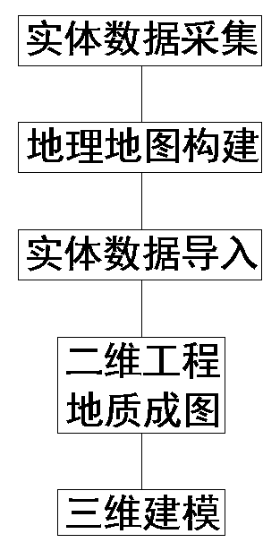
[0025] This embodiment describes a method for three-dimensional visualization processing of engineering geological information, such as figure 1 As shown, the processing steps include entity data acquisition, geographic map construction, entity data import, 2D engineering geological mapping and 3D modeling, a...


PUM


Abstract

The invention relates to an engineering geological information three-dimensional visualization processing method. the processing steps comprise entity data acquisition, geographic map construction, entity data import, two-dimensional engineering geological mapping and three-dimensional modeling; during three-dimensional modeling, a plurality of arc segments are formed by clicking drilling points to be connected on a geographic map, then rendering is carried out to generate boundaries of a three-dimensional image, different colors of filling of different rock-soil layers are carried out, a geologic body display map in a three-dimensional state is generated, and further visualization processing is facilitated. According to the invention, the collection and centralized processing of engineering geological information can be effectively improved, a visual three-dimensional geological body display graph can be formed, the visual three-dimensional geological body display graph is visual andvivid, various data are concentrated into one graph and are convenient to retrieve, and the cost of manpower and material resources can be greatly reduced.

Description

technical field [0001] The invention relates to the technical field of engineering geological survey, in particular to a three-dimensional visualization processing method for engineering geological information. Background technique [0002] Engineering geology is a discipline that applies the principles of geology to serve engineering applications. The main research contents involve geological hazards, rocks and Quaternary sediments, rock mass stability, earthquakes, etc. Engineering geology is widely used in various stages of engineering planning, survey, design, construction and maintenance. [0003] The purpose of engineering geology is to find out the geological conditions of various engineering sites, conduct a comprehensive evaluation of the site and its related geological problems, analyze and predict the possible changes and effects of geological conditions under the action of engineering buildings, Select the optimal site and propose engineering measures to solve u...

Claims


Application Information

Patent Timeline
Patent Type & Authority Applications(China)
IPC IPC(8): G06T17/05G06T11/20G01V99/00
CPCG06T11/206G06T17/05G01V99/005
Inventor 侯卫国王尚乔月石玉晗刘希
Owner 苏州微维大数据有限公司
Why Eureka
Try Eureka