
Remote sensing image forest land change detection method based on sparse DBN model

A remote sensing image, sparse technology, applied in character and pattern recognition, instruments, computer components, etc., can solve the problem of ignoring the details of high-resolution remote sensing images, achieve the effect of improving feature extraction capabilities and improving work efficiency

Pending Publication Date: 2019-04-16
广西壮族自治区遥感信息测绘院
View PDF3 Cites 3 Cited by
  • Summary
  • Abstract
  • Description
  • Claims
  • Application Information

AI Technical Summary

Problems solved by technology

[0004] Forest change detection is one of the necessary tasks for annual forest resource investigation and supervision. Conventional high-resolution remote sensing image forest change detection is mostly based on pixel change detection, ignoring the large and rich details of high-resolution remote sensing images.

Method used


Image

  • Remote sensing image forest land change detection method based on sparse DBN model
  • Remote sensing image forest land change detection method based on sparse DBN model
  • Remote sensing image forest land change detection method based on sparse DBN model

Examples


Embodiment Construction

[0015] The specific implementation manner of the present invention will be described in detail below in conjunction with the accompanying drawings and examples.

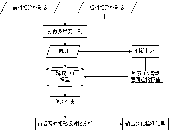
[0016] Such as figure 1 Shown, the present invention comprises the following steps:

[0017] Step 1. Use the fractal network evolution algorithm for multi-scale segmentation of high-resolution remote sensing images to ensure the spectral homogeneity in each image spot.

[0018] The fractal network evolution algorithm is based on the bottom-up growth of pixels, and under the premise of ensuring the minimum heterogeneity, the adjacent pixels with similar spectral information are merged into a spectrally homogeneous image spot.

[0019] Step 2. Calculate the NDVI of all image spots. Generally speaking, the larger NDVI value is forest land, while the smaller NDVI value is non-forest land. Arrange the NDVI values ​​from large to small, and select the top 20% with the largest NDVI value and the smallest top 20% or so as ...


PUM


Abstract

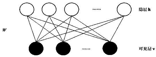
The invention discloses a remote sensing image forest land change detection method based on a sparse DBN model. The method comprises: step 1, segmenting a front-stage high-resolution remote sensing image and a rear-stage high-resolution remote sensing image; step 2, calculating vegetation coverage indexes of all image spots; step 3, adding sparse regular terms into the basic unit restricted Boltzmann machine of the deep belief network, and stacking the sparse restricted Boltzmann machine to form a sparse deep belief network; step 4, training a sparse deep belief network by using the sample obtained in the step 2 to obtain a sparse deep belief network model for forest land detection of the high-resolution remote sensing image; and step 5, automatically classifying all image spots by using the trained sparse depth confidence network. A sparse coding method is adopted on the basis of a human visual information system, sparse constraint is introduced into the DBN to obtain a sparse DBN model, and then high-resolution remote sensing image change detection is carried out on the basis of the sparse DBN model to obtain a forest land change detection result.

Description

technical field [0001] The invention belongs to the field of remote sensing image data processing, and relates to a method for autonomously learning images based on a sparse deep belief network (DBN) model, further automatically classifying images, and finally extracting forest land change information from high-resolution remote sensing images. Background technique [0002] With the implementation of the national sustainable development strategy, marked by the full start of the six key forestry projects, my country's forestry has entered a new stage of comprehensively promoting leapfrog development guided by the theory of sustainable development. However, the current forest resource survey and monitoring is mainly based on manual surveys on the ground. The technical means are backward, and the informatization and automation level of monitoring data collection, transmission and storage are low. It is greatly affected by human factors, and it is necessary to promote the develo...

Claims


Application Information

Patent Timeline
Patent Type & Authority Applications(China)
IPC IPC(8): G06K9/62G06K9/34
CPCG06V10/26G06F18/24
Inventor 刘润东余万东梅树红范城城黄发罗蔚生莫奇京李惺颖蒋齐跃王国忠麦超施宇军
Owner 广西壮族自治区遥感信息测绘院
Learn More