A method and device for carrying out augmented reality for a plane map

A flat map and augmented reality technology, applied in image data processing, instruments, etc., can solve the problems of no virtual 3D model fusion, lack of semantic description, single virtual 3D model, etc., to improve the effectiveness and recognition.

Pending Publication Date: 2019-06-04
BEIJING INFORMATION SCI & TECH UNIV
View PDF5 Cites 4 Cited by
  • Summary
  • Abstract
  • Description
  • Claims
  • Application Information

AI Technical Summary

Problems solved by technology

However, there are still many problems in the augmented reality application for planar maps. For example, the virtual 3D model used for augmented reality is relatively simple, lacks corresponding semantic description, and does not effectively integrate the virtual 3D model into the real scene.

Method used


Image

  • A method and device for carrying out augmented reality for a plane map
  • A method and device for carrying out augmented reality for a plane map
  • A method and device for carrying out augmented reality for a plane map

Examples


Embodiment Construction

[0020] The general idea of ​​the present invention is to construct a three-dimensional virtual space map for a planar map by using tags containing augmented reality information and semantic description information related to map constituent elements, so as to improve the validity and effectiveness of the expression of each map constituent element in a planar map. resolution.

[0021] Hereinafter, embodiments of the present invention will be described in detail with reference to the accompanying drawings.

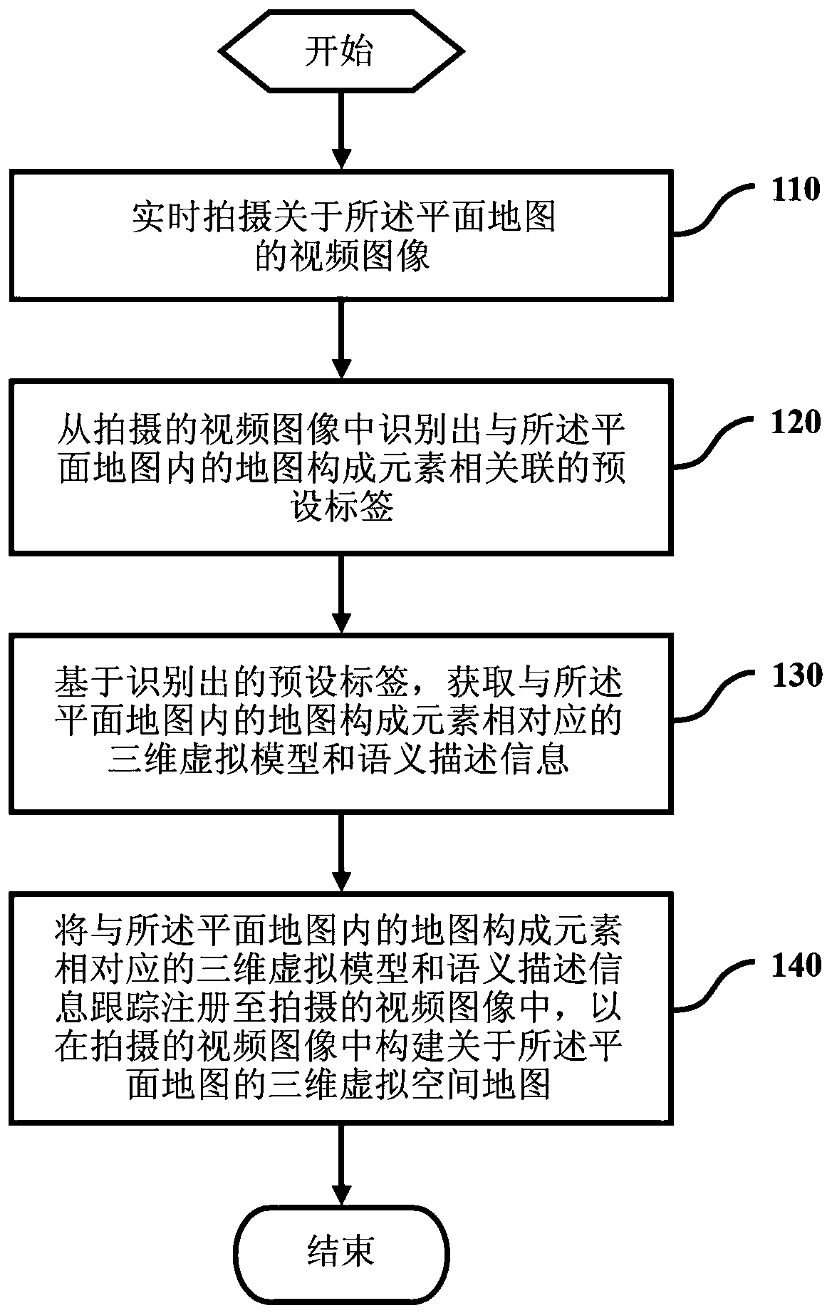
[0022] figure 1 is a flowchart showing a method for performing augmented reality on a planar map according to an exemplary embodiment of the present invention.

[0023] In step 110, a video image about the planar map is captured in real time by a video capture unit (such as a camera).

[0024] Here, as an example, the planar map may be a traditional planar paper map, or other maps in any planar form that can be photographed.

[0025] Next, in step 120, the preset labels a...


PUM


Abstract

The invention provides a method and device for carrying out augmented reality for a plane map, and the method comprises the steps: shooting a video image of the plane map in real time; Identifying a preset label associated with a map composition element in the plane map from the shot video image; Based on the identified preset label, obtaining a three-dimensional virtual model and semantic description information corresponding to map composition elements in the plane map; And tracking and registering a three-dimensional virtual model and semantic description information corresponding to map composition elements in the plane map into a shot video image to construct a three-dimensional virtual space map about the plane map in the shot video image.

Description

technical field [0001] The present application relates to the field of map information display, and in particular to a method and device for performing augmented reality on a planar map. Background technique [0002] With the rapid development of augmented reality technology research and the deepening of the application of maps and geographic information, while augmented reality has become a research hotspot, people are trying to apply augmented reality technology to the display enhancement of planar maps and the visualization of geographic information. However, there are still many problems in the augmented reality application for planar maps. For example, the virtual 3D model used for augmented reality is relatively simple, lacks corresponding semantic description, and does not effectively integrate the virtual 3D model into the real scene. [0003] Therefore, there is an urgent need for an augmented reality method and device for a planar map that can solve the above probl...

Claims


Application Information

Patent Timeline
IPC IPC(8): G06T19/00
Inventor 王占刚朱希安
Owner BEIJING INFORMATION SCI & TECH UNIV
Why Eureka
Try Eureka