CORS (Continuously Operating Reference Stations) system-based real-time positioning service method for local coordinates

A service method and real-time positioning technology, applied in the field of surveying and mapping geographic information, can solve problems such as difficult quality control of results, cumbersome operations, and difficulty in ensuring conversion accuracy, so as to solve the problem of elevation conversion, ensure positioning accuracy and reliability, and improve automation and the effect of efficiency

Active Publication Date: 2019-06-14
自然资源部第三大地测量队
View PDF7 Cites 8 Cited by
  • Summary
  • Abstract
  • Description
  • Claims
  • Application Information

AI Technical Summary

Problems solved by technology

[0003] Since the seven parameters of the ellipsoid transformation, quasi-geoid model, and elevation fitting parameters in the above transformation process are state secret data, they cannot be provided or leaked to public users at will. Therefore, the above coordinate transformation is subject to many restrictions
[0004] In order to realize the above-mentioned coordinate conversion, the traditional methods are as follows: 1) After the user terminal completes the RTK measurement, submit the coordinate results to the qualified surveying and mapping results storage department for subsequent conversion. This method has good confidentiality, but the efficiency is extremely low and cannot be converted in real time; 2) After the user terminal completes the RTK measurement, use the authorized account to log in to the online coordinate conversion system provided by the surveying and mapping results storage department, complete the coordinate conversion on the server side, and export the results online. This method has better confidentiality, but it still cannot convert in real time; 3 ) The user uses several control point results with two sets of coordinates to perform point calibration and calculate conversion parameters in a small area. This method is cumbersome to operate, the conversion accuracy is difficult to guarantee, and there is a risk of leakage of control point coordinates and conversion parameters; 4 ) encrypts the conversion parameters through an algorithm, and then solidifies them into the user terminal equipment. This method cannot ensure that the conversion parameters are not leaked, and has high requirements for the equipment, and it is necessary to modify the hardware and software of the equipment.
[0005] To sum up, the existing CORS system positioning has defects such as the inability to convert coordinates in real time, low conversion efficiency, poor security, and difficult quality control of results.

Method used


Image

  • CORS (Continuously Operating Reference Stations) system-based real-time positioning service method for local coordinates
  • CORS (Continuously Operating Reference Stations) system-based real-time positioning service method for local coordinates
  • CORS (Continuously Operating Reference Stations) system-based real-time positioning service method for local coordinates

Examples


Embodiment Construction

[0070] The principles and features of the present invention are described below in conjunction with the accompanying drawings, and the examples given are only used to explain the present invention, and are not intended to limit the scope of the present invention.

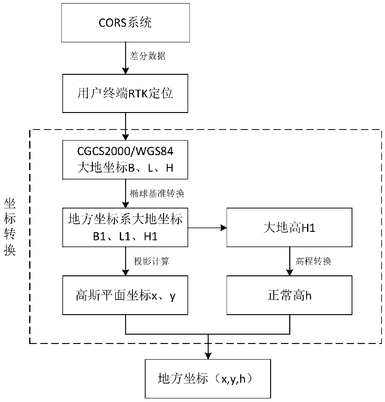
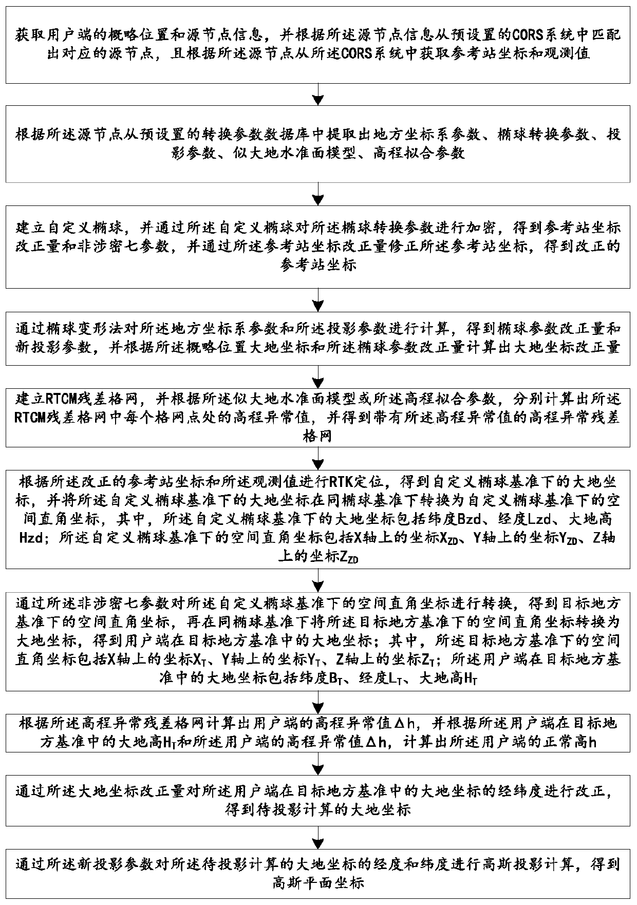
[0071] Such as figure 2 As shown, a kind of local coordinate real-time positioning service method based on CORS system provided by the embodiment of the present invention comprises the following steps:

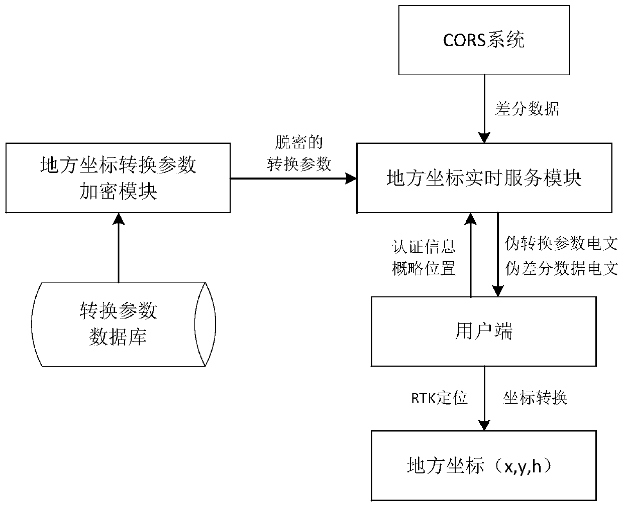
[0072] Step 1, obtain the approximate location and source node information of the client, and match the corresponding source node from the preset CORS system according to the source node information, and obtain the reference station coordinates from the CORS system according to the source node and observed values.

[0073] Step 2, extract local coordinate system parameters, ellipsoid conversion parameters, projection parameters, quasi-geoid model, and elevation fitting parameters from the preset conversion paramet...


PUM


Abstract

The invention relates to a CORS (Continuously Operating Reference Stations) system-based real-time positioning service method for local coordinates. The method has the beneficial effects that the encryption of seven real ellipsoid conversion parameters is realized by adopting a custom ellipsoid encryption method and the influence of the encryption method on RTK (Real-Time Kinematic) positioning istaken into account to strictly control the offset at the same time; the ellipsoid parameters are converted by adopting an ellipsoid deformation method, thereby eliminating the projection high parameters and solving the contradiction that the projection high parameters cannot be broadcasted in RTCM (Radio Technical Commission for Maritime services) message; generating a grid around a user positionby using the user position as the center, interpolating elevation abnormal values of grid points by using an existing elevation conversion model, generating RTCM residual grid message and broadcasting to the user end, thereby obtaining the normal height of the user end, solving the elevation conversion problem and not affecting the RTK baseline solution at the same time; and by implementing the method disclosed by the invention, after the user terminal receives pseudo conversion parameter message, the Gaussian plane coordinates and the normal height can be directly obtained with no need for configuring any parameters, thereby guaranteeing the security, the real-time performance and the universality of the local coordinate positioning.

Description

technical field [0001] The invention relates to the technical field of surveying and mapping geographic information, in particular to a CORS system-based real-time positioning service method for local coordinates. Background technique [0002] The user terminal uses the CORS system for RTK positioning, and the obtained coordinates belong to the China Geodetic Coordinate System 2000 (CGCS2000) or WGS84 geodetic coordinate system (WorldGeodetic System 1984), and the measurement field of our country usually uses the coordinates of the local coordinate system, namely Gaussian plane coordinates x, y and normal height h are used as the form of measurement results, so there is an inevitable coordinate conversion process. The coordinate transformation process is as figure 1 As shown, it is necessary to use seven parameters for ellipsoid datum transformation, use quasi-geoid model or elevation fitting parameters for elevation transformation, and use projection parameters for Gaussia...

Claims


Application Information

Patent Timeline
Patent Type & Authority Applications(China)
IPC IPC(8): G01S19/43H04L9/30
Inventor 成兵张熙胡可陈现春李鹏谭斌
Owner 自然资源部第三大地测量队
Why Eureka
Try Eureka