Unmanned vehicle positioning method based on multi-sensor data fusion

A data fusion and multi-sensor technology, applied in satellite radio beacon positioning systems, instruments, radio wave measurement systems, etc., can solve the problems of inertial navigation equipment error accumulation over time, poor real-time performance of lidar and visual sensors, and satellite navigation receivers Poor continuity and other issues, to achieve the effect of reliable high-precision positioning data

Active Publication Date: 2019-06-28
李子月
View PDF7 Cites 21 Cited by
  • Summary
  • Abstract
  • Description
  • Claims
  • Application Information

AI Technical Summary

Problems solved by technology

[0005] Aiming at many problems such as the poor continuity of satellite navigation receivers, the accumulation of inertial navigation equipment errors over time, and the poor real-time performance o

Method used


Image

  • Unmanned vehicle positioning method based on multi-sensor data fusion
  • Unmanned vehicle positioning method based on multi-sensor data fusion
  • Unmanned vehicle positioning method based on multi-sensor data fusion

Examples


Embodiment Construction

[0035] The present invention will be further described below in conjunction with the accompanying drawings.

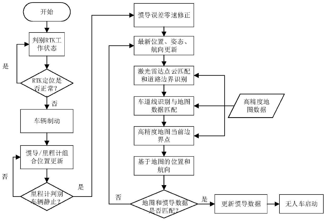
[0036] A method for positioning an unmanned vehicle based on multi-sensor data fusion, comprising the steps of:

[0037] (1) Through the positioning data output by the satellite navigation receiver, the validity of the data is monitored in real time. When either of the two situations of PDOP>5 and the number of visible stars is less than or equal to 4, it is judged that the availability of satellite positioning data has decreased;

[0038] (2) When the availability of satellite positioning data declines, the unmanned vehicle brakes. During the braking process, the positioning position is updated through the fusion of the odometer and inertial navigation data. After the vehicle is stationary, the pitch angle error of the inertial navigation equipment, Roll angle error, heading angle error, accelerometer and gyroscope constant value error are corrected, the specific proc...


PUM


Abstract

The invention discloses an unmanned vehicle positioning method based on multi-sensor data fusion. With data of a centimeter-level high-precision map, vision and a laser radar sensor, high-precision positioning is realized in an area with satellite positioning signals shielded. According to the invention, because of real-time monitoring of effectiveness of the satellite positioning data, the satellite positioning data are assisted by using the fusion of data of the centimeter-level high-precision map, the laser radar, the odometer, and the multiple visual sensors. Meanwhile, the inertial navigation accumulation error is corrected; the reliability, continuity and accuracy of the positioning system are improved; and no cost of the sensor hardware is increased.

Description

technical field [0001] The invention relates to the field of positioning and navigation in unmanned vehicle technology, in particular to an unmanned vehicle positioning method based on multi-sensor data fusion. Background technique [0002] As DARPA restarted the research on unmanned vehicle technology, and held three smart car challenges in 2004, 2005 and 2007, Google invested heavily in the research of autonomous driving technology. upsurge. Participants include top Internet companies such as Google, Apple, Uber, and BAT, as well as traditional car companies such as Tesla, Mercedes-Benz, BMW, GM, and Cadillac. At the same time, component suppliers such as Intel, Nvidia, Bosch, and Mobileye also participated , In addition, start-up companies in the field of autonomous driving have sprung up like mushrooms after rain. [0003] After more than ten years of development, autonomous driving technology has gradually evolved from laboratory research, to closed environment techno...

Claims


Application Information

Patent Timeline
IPC IPC(8): G01S19/48G01C21/16G01C21/00
Inventor 李子月
Owner 李子月
Why Eureka
Try Eureka