Agricultural and forestry crop identification method based on medium-high resolution time sequence remote sensing data

A high-resolution, remote sensing data technology, applied in the field of remote sensing applications, can solve the problems of insufficient information utilization, low accuracy of crop category recognition, and low degree of interpretation automation

Active Publication Date: 2019-07-02
BEIJING AEROSPACE TITAN TECH CO LTD
View PDF3 Cites 5 Cited by
  • Summary
  • Abstract
  • Description
  • Claims
  • Application Information

AI Technical Summary

Problems solved by technology

[0007] The purpose of the present invention is to overcome the problems that the current multi-source remote sensing data cannot be fully utilized in the identification of agricultural and forestry crops, the degree of interpretation automation is low, and the accuracy of crop category identification is low.

Method used


Image

  • Agricultural and forestry crop identification method based on medium-high resolution time sequence remote sensing data
  • Agricultural and forestry crop identification method based on medium-high resolution time sequence remote sensing data
  • Agricultural and forestry crop identification method based on medium-high resolution time sequence remote sensing data

Examples


Embodiment Construction

[0032] The embodiments of the present invention will be described in detail below in conjunction with the accompanying drawings, so that the advantages and features of the present invention can be more easily understood by those skilled in the art, so as to define the protection scope of the present invention more clearly.

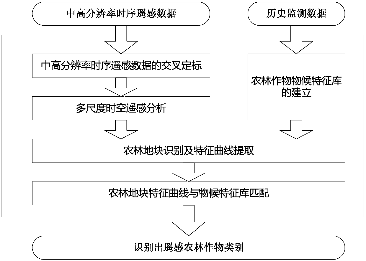
[0033] 1. Overall technical process

[0034] The overall technical process of this patent is attached figure 1 shown. It is mainly divided into 5 links, namely cross-calibration of medium and high-resolution time-series remote sensing data, construction of multi-scale spatio-temporal remote sensing analysis framework, establishment of agricultural and forestry crop phenological characteristics database, identification of agricultural and forestry plots and extraction of characteristic curves, and characteristic curves of agricultural and forestry plots Matched with the phenological signature library. Through these technical links, various problems in the...


PUM


Abstract

The invention discloses an agricultural and forestry crop identification method based on medium-high resolution time sequence remote sensing data. The method comprises the steps of 1) carrying out thecross calibration on remote sensing images observed by multiple medium-high resolution remote sensors in the same region at different times; 2) for remote sensing images with different spatial resolutions, forming a remote sensing time sequence data set with consistent spatial resolutions and short time intervals on the basis of cross calibration; 3) segmenting the agriculture and forestry land parcels in the remote sensing image by using an image segmentation method to obtain the boundary of each land parcel; 4) analyzing the remote sensing time sequence data set by taking the land parcels as units, and counting the average value and variance of the spectral band reflectivity, the normalized vegetation index and the leaf area index of the land parcels in each period; sorting the statistical characteristics according to time to form a plurality of characteristic curves of the plot; and 5) matching the plurality of characteristic curves of the agriculture and forestry land parcels withthe phenological characteristic library to obtain the crop types of the land parcels.

Description

technical field [0001] The invention relates to the field of remote sensing applications, in particular to the application of medium and high-resolution time-series remote sensing data in identifying agricultural and forestry crops, and in particular to a method for identifying agricultural and forestry crops based on medium- and high-resolution time-series remote sensing data. Background technique [0002] The identification of agricultural and forestry crops is the basis of remote sensing monitoring of agricultural and forestry crops such as growth monitoring and crop yield estimation. There are three main methods for remote sensing identification of agricultural and forestry crops: [0003] 1. Manual visual interpretation. Professionals obtain specific target object information on remote sensing images through direct observation or with the help of auxiliary interpretation instruments. This method is limited by the technical level of personnel and is labor-intensive and...

Claims


Application Information

Patent Timeline
Patent Type & Authority Applications(China)
IPC IPC(8): G06K9/00G06K9/34G06K9/62
CPCG06V20/188G06V10/267G06F18/22
Inventor 李磊谭靖姜航陈宏磊
Owner BEIJING AEROSPACE TITAN TECH CO LTD
Why Eureka
Try Eureka