Emergency aid decision making system based on GIS and BIM

A technology that assists decision-making and emergency rescue. It is applied in computer-aided design, data processing applications, special data processing applications, etc., and can solve the problems of BIM technology with less ink, inability to optimize open-pit mine areas, and imperfect emergency management platforms.

Inactive Publication Date: 2019-07-12
华夏天信物联科技有限公司
View PDF3 Cites 32 Cited by
  • Summary
  • Abstract
  • Description
  • Claims
  • Application Information

AI Technical Summary

Problems solved by technology

[0003] The present invention provides an emergency auxiliary decision-making system based on GIS and BIM. By combining GIS and BIM technology, the imperfect emergency management platform of GIS open-pit mine area in the prior art is solved. With the wide application of GIS technology, the research focus is on In the emergency response of the open-pit mine area, BIM technology has little ink in the design of the open-pit mine area, so it is impossible to comprehensively optimize the open-pit mine area. This system focuses on prevention, combined with the system scheduling of fire protection and emergency forces, comprehensive Improve the fire protection capability of the open pit mine area

Method used


Image

  • Emergency aid decision making system based on GIS and BIM
  • Emergency aid decision making system based on GIS and BIM
  • Emergency aid decision making system based on GIS and BIM

Examples


Embodiment Construction

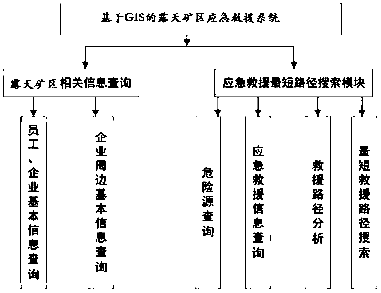
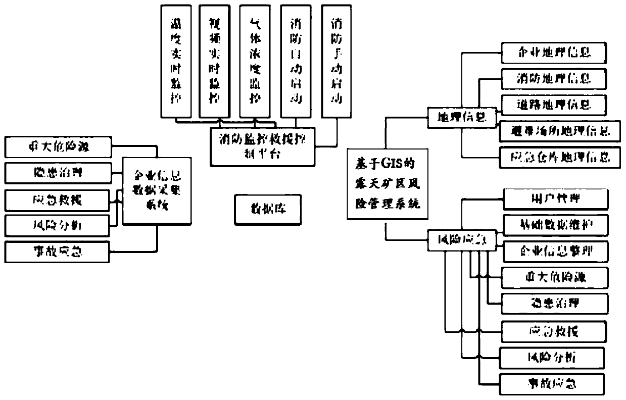
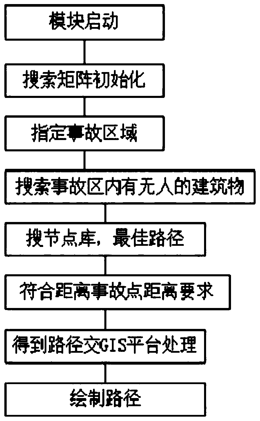
[0020] The emergency auxiliary decision-making system based on GIS and BIM provided by the present invention combines GIS and BIM to realize interconnection and interoperability at the data level. Based on GIS, it integrates BIM for modeling and builds a unified multi-scale three-dimensional display platform for open-pit mine areas. The GIS-based emergency rescue management system integrates the BIM model pipeline data to build a risk management and emergency rescue auxiliary decision-making system. The risk management and emergency rescue auxiliary decision-making system is divided into a GIS-based open-pit mine area emergency rescue management system and associated risks management system.

[0021] For the unestablished open-pit mine area, GIS can be used for site selection. For the established open-pit mine area, this system can be used to collect relevant data, and use BIM modeling to carry out related management.

[0022] Then, the site selection and simulation management...


PUM


Abstract

The invention provides an emergency aid decision making system based on a GIS and a BIM. According to the method, a GIS and a BIM are combined to realize interconnection and mutual homogeneity on a data level, a unified multi-scale open-pit mine area three-dimensional display platform is constructed, an emergency rescue management system based on the GIS is constructed, BIM model pipeline data isfused, and a risk management and emergency rescue aid decision making system is constructed. According to the method, two spatial information technologies of GIS and BIM are combined, interconnectionand mutual homogeneity of the two technologies on the data level are achieved, quantitative analysis is conducted on the strip mine area, and a designer is assisted in planning the strip mine area. Original data of a project site can be well stored for a designer, and the data can have a good supporting effect on later-period management such as planning, construction and operation maintenance.

Description

technical field [0001] The invention relates to the area safety system field of open-pit mines, in particular to an emergency auxiliary decision-making system based on GIS and BIM. Background technique [0002] The chemical industrial park, referred to as the open-pit mine area, is derived from the intensification and maximization of the modern chemical industry in order to adapt to the conversion of resources and raw materials. For the purpose of centralized utilization of resources, industrial agglomeration and industrial optimization, the development of the world's petrochemical industry shows a tendency to agglomerate , thus deriving the open-pit mine area; as long as the site selection of the open-pit mine area has the following factors, namely infrastructure facilities, transportation convenience, information system, resource guarantee, policy, etc., based on the site selection of the open-pit mine area, it will provide urban workers Safety planning brings challenges b...

Claims


Application Information

Patent Timeline
Patent Type & Authority Applications(China)
IPC IPC(8): G06F17/50G06Q50/26G06T17/10
CPCG06Q50/265G06T17/10G06F30/20
Inventor 高强王静宜郑晓磊
Owner 华夏天信物联科技有限公司
Why Eureka
Try Eureka