High-precision augmented reality method and equipment based on geographical location positioning

A geolocation positioning and augmented reality technology, applied in satellite radio beacon positioning systems, measurement devices, navigation through speed/acceleration measurement, etc. question

Active Publication Date: 2019-07-19
杭州易绘科技有限公司
View PDF5 Cites 7 Cited by
  • Summary
  • Abstract
  • Description
  • Claims
  • Application Information

AI Technical Summary

Problems solved by technology

[0003] However, at present, the global satellite positioning accuracy of ordinary mobile phones and mobile terminals is more than 10 meters, and the positioning error of the geographical location is too large, so the accuracy of superimposing the virtual scene and the real scene is far apart, and often the virtual scene is in the real scene Accumulated position deviation of the situation, resulting in greatly reduced augmented reality effect and value
Of course, there are other auxiliary positioning technologies currently on the market, such as: two-dimensional code or image recognition, auxiliary positioning of nearby buildings or markers, infrared or WIFI positioning, etc. However, the above-mentioned auxiliary positioning technologies are found in practical applications. The technology has defects such as poor superposition effect, high-cost hardware investment, high-cost technology investment, etc., and cannot be widely used

Method used


Image

  • High-precision augmented reality method and equipment based on geographical location positioning
  • High-precision augmented reality method and equipment based on geographical location positioning
  • High-precision augmented reality method and equipment based on geographical location positioning

Examples


Embodiment Construction

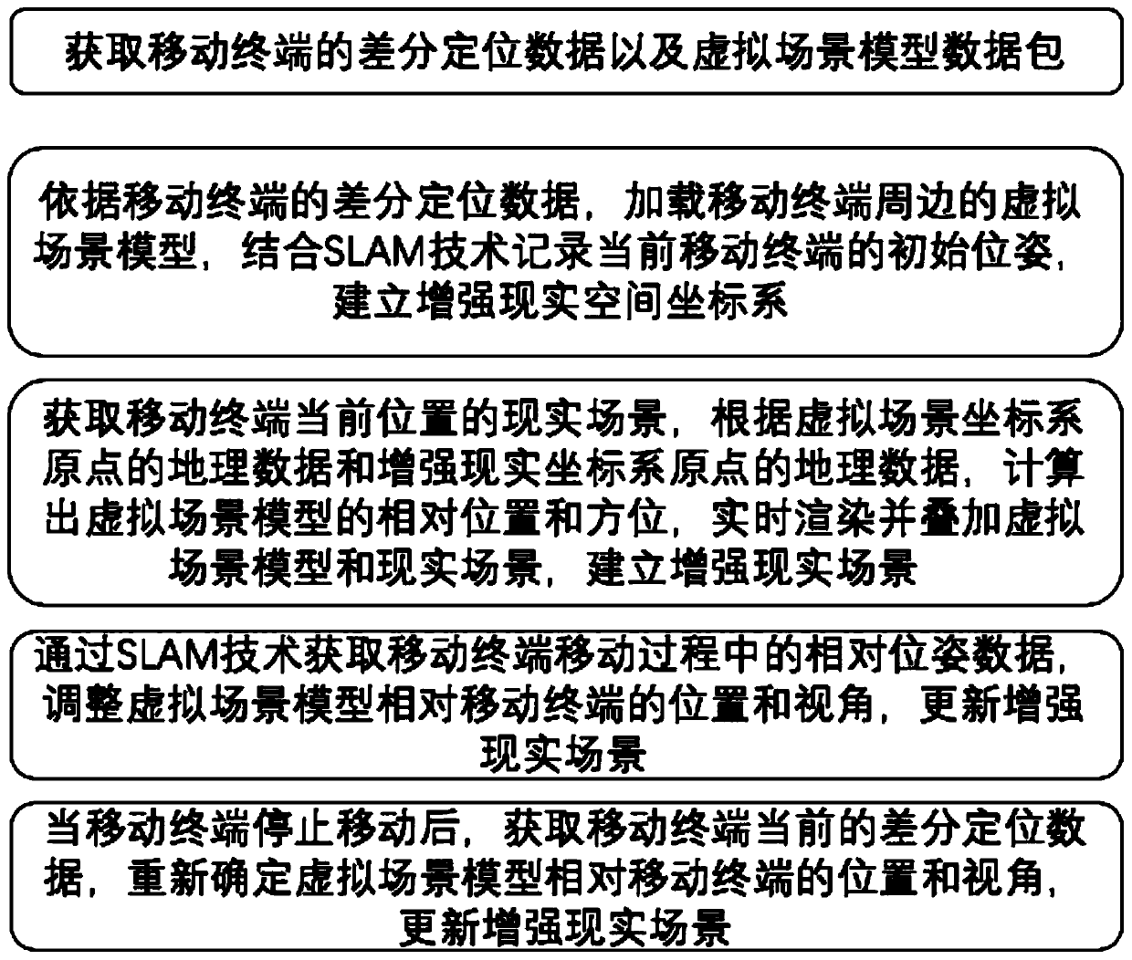
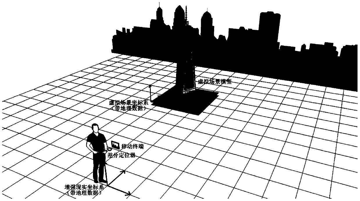
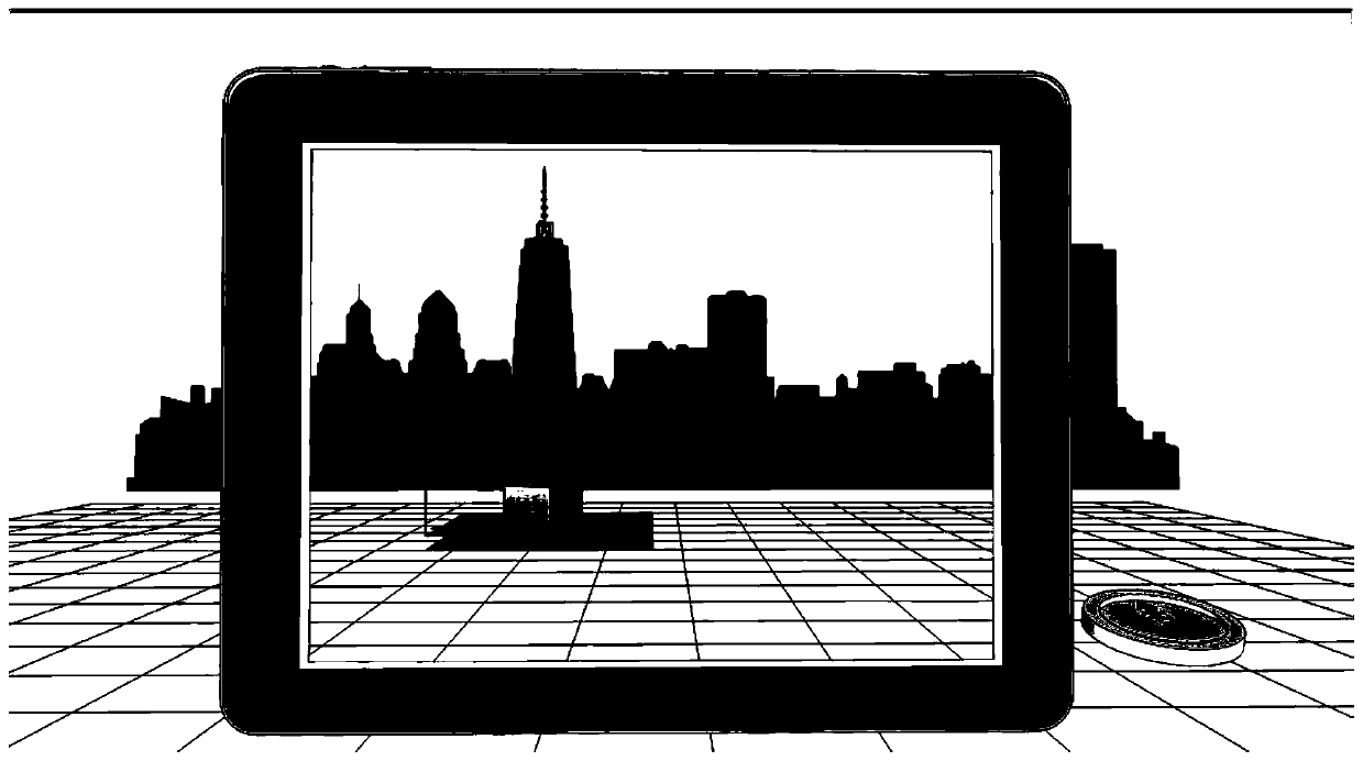
[0029] The following will clearly and completely describe the technical solutions in the embodiments of the present invention with reference to the accompanying drawings in the embodiments of the present invention. Obviously, the described embodiments are only some, not all, embodiments of the present invention. All other embodiments obtained by persons of ordinary skill in the art based on the embodiments of the present invention belong to the protection scope of the present invention.

[0030] Those skilled in the art should understand that in the disclosure of the present invention, the terms "vertical", "transverse", "upper", "lower", "front", "rear", "left", "right", " The orientation or positional relationship indicated by "vertical", "horizontal", "top", "bottom", "inner", "outer", etc. is based on the orientation or positional relationship shown in the drawings, which are only for the convenience of describing the present invention and The above terms should not be con...


PUM


Abstract

The invention provides a high-precision augmented reality method based on geographical location positioning. The high-precision augmented reality method combines a differential global positioning system, so that centimeter-level high-precision positioning data is provided; besides, an SLAM technology is utilized, relative positioning of a mobile terminal is obtained and a map is built timely, so that accuracy of augmented reality in a moving process is improved, and then application of the augmented reality in a real scene is enhanced.

Description

technical field [0001] The invention relates to the field of augmented reality, in particular to a high-precision reality method and device based on geographic location positioning. Background technique [0002] Augmented Reality (Augmented Reality), referred to as AR, is a technology that calculates the position and angle of camera images in real time and adds corresponding images, videos, and 3D models. The goal of this technology is to superimpose virtual scenes into real scenes. Superimpose the real environment and virtual objects into the same picture and space in real time and exist simultaneously. Due to its characteristics of combining virtual and real, it is more and more widely used in urban planning and management, especially the augmented reality system based on geographical location, which can apply virtual scenes according to the geographical location of real scenes. [0003] However, at present, the global satellite positioning accuracy of ordinary mobile pho...

Claims


Application Information

Patent Timeline
Patent Type & Authority Applications(China)
IPC IPC(8): G01S19/45G01S19/47G01C21/16
CPCG01C21/165G01S19/45G01S19/47
Inventor 柯紫云俞园萍
Owner 杭州易绘科技有限公司
Why Eureka
Try Eureka