Check patentability & draft patents in minutes with Patsnap Eureka AI!

Spatio-temporal data integrated management method based on chain storage

A spatiotemporal data, chain storage technology, applied in the field of geospatial information data processing, can solve the problems of not establishing the relationship between update elements and original elements, lack of practical spatiotemporal data management methods, and difficulty in effectively exerting the huge value of geographic information, etc. To achieve the effect of saving time sorting overhead, saving user costs, and wide application

Active Publication Date: 2019-07-19
CHONGQING GEOMATICS & REMOTE SENSING CENT
View PDF8 Cites 2 Cited by
  • Summary
  • Abstract
  • Description
  • Claims
  • Application Information

AI Technical Summary

Problems solved by technology

[0002] The management of spatio-temporal data has always been a difficult problem in the field of geospatial information applications. At this stage, mainstream GIS platforms such as ArcGIS and Hypermap are mainly used to establish multiple time versions to manage spatio-temporal data of different time dimensions. This management method requires storage for each version. The full amount of data in the version causes a large amount of data redundancy. At the same time, the data update efficiency is low and the update cycle is long. Moreover, because the data is updated simply after editing the data, there is no relationship between the updated elements and the original elements. Realize element-level spatio-temporal retrospective query
[0003] With the implementation of the national strategy, there will be more and more geographic information databases for different application fields. Without a feasible spatio-temporal data management method, it will be difficult to effectively exert the huge value contained in geographic information.

Method used


Image

  • Spatio-temporal data integrated management method based on chain storage
  • Spatio-temporal data integrated management method based on chain storage
  • Spatio-temporal data integrated management method based on chain storage

Examples


Embodiment Construction

[0045] The specific implementation manner and working principle of the present invention will be further described in detail below in conjunction with the accompanying drawings.

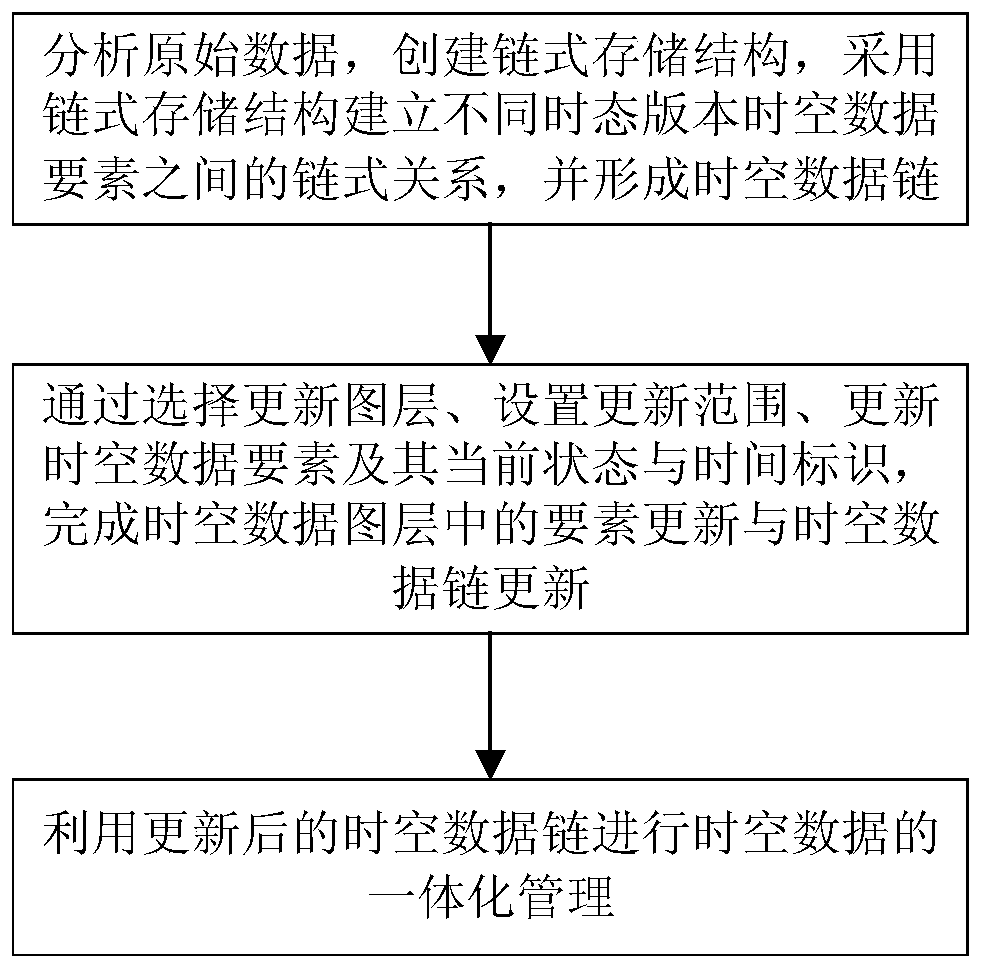
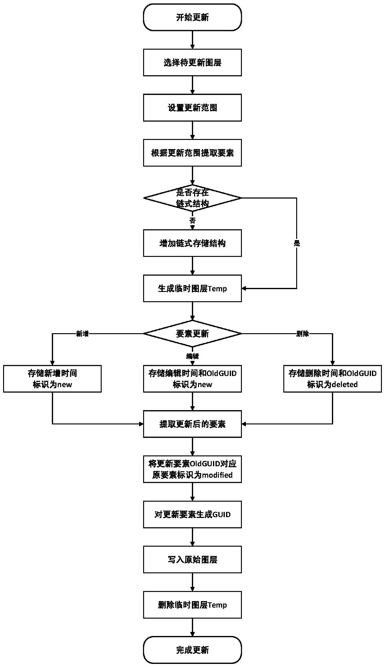
[0046] Such as figure 1 As shown, an integrated management method of spatio-temporal data based on chain storage, the specific steps are as follows:

[0047] Step 1: Analyze the original data, create a chained storage structure, use the chained storage structure to establish the chained relationship between the spatiotemporal data elements of different temporal versions, and form a spatiotemporal data chain;

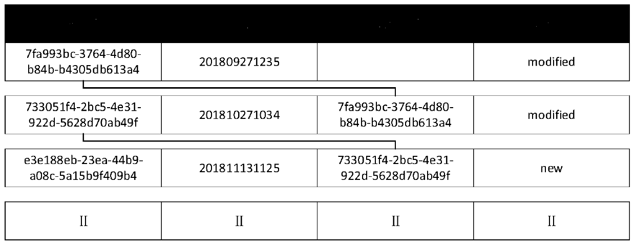
[0048] Such as figure 2 As shown, the chained storage structure includes four fields GUID, Time, OldGUID, and Status, wherein the GUID field is used to store the globally unique identifier of the current temporal state of the spatiotemporal data element, and the Time field is used to store the spatiotemporal data element The time of adding, deleting, and editing, the OldGUID field is used to...


PUM


Abstract

The invention discloses a spatio-temporal data integrated management method based on chain storage. The method comprises the following steps: analyzing original data, creating a chain type storage structure comprising four fields of GUID, Time, OldGUID and Status, establishing a chain type relation among spatio-temporal data elements of different time versions by adopting the chain type storage structure, and forming a space-time data chain; selecting a layer to be updated, setting an updating range, and updating spatio-temporal data elements and current states and global unique identifiers thereof to complete element updating and spatio-temporal data chain updating in the spatio-temporal data layer; and carrying out integrated management on the spatio-temporal data by utilizing the updated spatio-temporal data chain. The method has the remarkable effects that the spatio-temporal data chain is formed based on chain storage, only the updated data needs to be stored when space-time datamanagement is carried out, redundancy caused by repeated storage of data of different versions is remarkably reduced, and the efficiency of element space-time tracing query is improved.

Description

technical field [0001] The invention relates to the technical field of geospatial information data processing, in particular to a chain storage-based spatio-temporal data integrated management method. Background technique [0002] The management of spatio-temporal data has always been a difficult problem in the field of geospatial information applications. At this stage, mainstream GIS platforms such as ArcGIS and Hypermap are mainly used to establish multiple time versions to manage spatio-temporal data of different time dimensions. This management method requires storage for each version. The full amount of data in the version causes a large amount of data redundancy. At the same time, the data update efficiency is low and the update cycle is long. Moreover, because the data is updated simply after editing the data, there is no relationship between the updated elements and the original elements. Realize element-level spatio-temporal retrospective query. [0003] With the ...

Claims


Application Information

Patent Timeline
IPC IPC(8): G06F16/29
CPCG06F16/29
Inventor 杨航曾安明余静贾敦新张治清梁星袁超李林赵翔宇余洋陈雪洋程宇翔王炜刘骏黄潇莹
Owner CHONGQING GEOMATICS & REMOTE SENSING CENT
Features
  • R&D
  • Intellectual Property
  • Life Sciences
  • Materials
  • Tech Scout
  • Unparalleled Data Quality
  • Higher Quality Content
  • 60% Fewer Hallucinations
Learn More