Supercharge Your Innovation With Domain-Expert AI Agents!

Gravity-assisted inertial navigation area adaptability evaluation method based on virtual heading

A technology of inertial navigation and evaluation method, applied in the field of adaptability evaluation of gravity-assisted inertial navigation area based on virtual heading, can solve the problems of inferior non-adaptive area and poor matching effect, and achieve the effect of improving matching efficiency

Active Publication Date: 2019-08-02
BEIJING INSTITUTE OF TECHNOLOGYGY
View PDF9 Cites 6 Cited by
  • Summary
  • Abstract
  • Description
  • Claims
  • Application Information

AI Technical Summary

Problems solved by technology

In actual navigation, there is a high probability of passing this area in a direction that is not suitable for matching, and the matching effect is poor, even not as good as some non-adaptive areas, so it is easy to cause misleading

Method used


Image

  • Gravity-assisted inertial navigation area adaptability evaluation method based on virtual heading
  • Gravity-assisted inertial navigation area adaptability evaluation method based on virtual heading
  • Gravity-assisted inertial navigation area adaptability evaluation method based on virtual heading

Examples


Embodiment

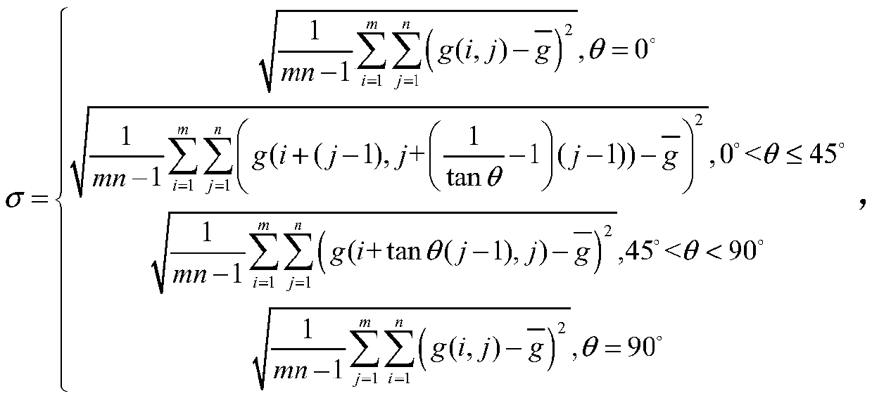
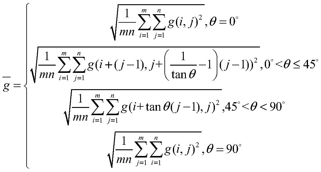
[0058] Example: Take a marine area with a longitude and latitude span of 5°×5°, a resolution of 2'×2', and a resolution of 1'×1' after cubic function interpolation, and analyze the suitability of each grid point. The process is as follows:

[0059] Step 1, calculate the standard deviation of the gravity anomaly based on the virtual heading:

[0060] Calculate the statistical parameters of the standard deviation of the gravity anomaly when the virtual heading angle θ of the local area is 0°, 45° and 90° respectively,

[0061]

[0062]

[0063] Note, the above formula and the following formula or tanθ is essentially shown as or round(tanθ).

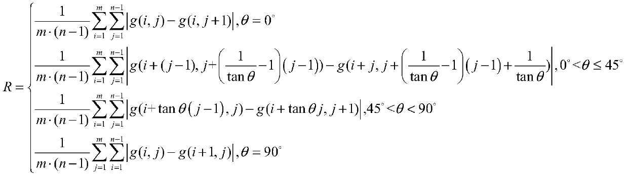
[0064] Step 2, calculate the absolute roughness of the gravity anomaly based on the virtual heading:

[0065] Calculate the absolute roughness statistical parameters of the gravity anomaly when the virtual heading angle θ of the local area is 0°, 45° and 90° respectively,

[0066]

[0067] Step 3, calculate the gravity anoma...


PUM


Abstract

The invention discloses a gravity-assisted inertial navigation area adaptability evaluation method based on virtual heading. The method is characterized by determining an adaptability analysis calculation range based on a direction, and determining a gravity characteristic parameter expression; using an analytic hierarchy process to fuse multiple characteristic parameters so as to obtain a comprehensive characteristic parameter; under a condition that each characteristic parameter weight and a selection threshold are consistent, giving adaptation areas selected by a navigation area in different directions so that selection of the adaptation areas is accurate and matching efficiency is increased, and important guidance information is provided for underwater carrier navigation and gravity matching; A traditional gravity characteristic parameter calculation formula is improved to calculate a corresponding gravity characteristic parameter based on any virtual given heading, and gravity characteristic description of the area is more directional and intuitive.

Description

technical field [0001] The invention belongs to the technical field of integrated navigation, in particular to a method for evaluating the area adaptability of gravity-assisted inertial navigation based on virtual course. Background technique [0002] Inertial navigation is the main navigation method used in underwater positioning and navigation at present. It can give multiple information such as position and attitude at the same time, and the short-term navigation accuracy is high. However, due to the error of the inertial component itself, the installation error of the inertial component, and the limitation of the principle of inertial navigation, its positioning error will accumulate over time. During the long voyage, the accuracy of inertial navigation will not be able to guarantee the safety of carrier navigation and the requirements of performing tasks. Therefore, other auxiliary navigation methods are required to periodically readjust and correct its errors. Gravit...

Claims


Application Information

Patent Timeline
IPC IPC(8): G01C21/16
CPCG01C21/165
Inventor 王博周明龙邓志红肖烜
Owner BEIJING INSTITUTE OF TECHNOLOGYGY
Features
  • R&D
  • Intellectual Property
  • Life Sciences
  • Materials
  • Tech Scout
  • Unparalleled Data Quality
  • Higher Quality Content
  • 60% Fewer Hallucinations
Learn More