Overhead power transmission line optimized line selection method based on airborne laser radar data

A technology of airborne laser radar and line selection method, which is applied in the directions of overhead line/cable equipment, electromagnetic wave re-radiation, radio wave measurement system, etc. problems such as low speed and low precision, and achieve the effects of realistic 3D visualization, significant social and economic benefits, and rapid scheduling and management.

Inactive Publication Date: 2008-12-31
GUANGXI ELECTRIC POWER IND INVESTIGATION DESIGN & RES INST
View PDF0 Cites 58 Cited by
  • Summary
  • Abstract
  • Description
  • Claims
  • Application Information

AI Technical Summary

Problems solved by technology
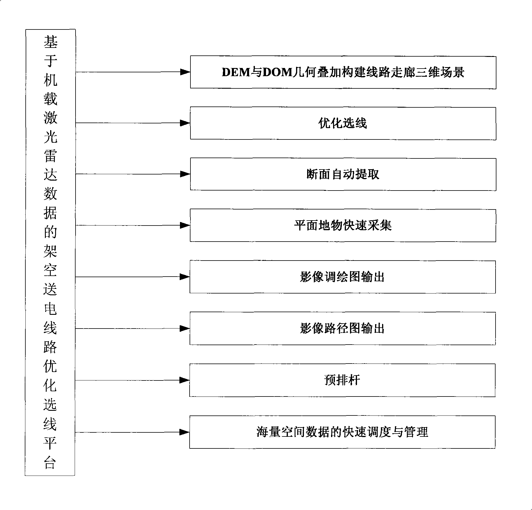
[0003] 1. Low precision
Especially for densely vegetated areas, the accuracy of the collection of office plan and section maps is low due to the inability to accurately target the ground surface;
[0004] 2. Low efficiency
Data processing in the office must be carried out with the help of field image contr

Method used


Image

  • Overhead power transmission line optimized line selection method based on airborne laser radar data
  • Overhead power transmission line optimized line selection method based on airborne laser radar data
  • Overhead power transmission line optimized line selection method based on airborne laser radar data

Examples


Embodiment Construction

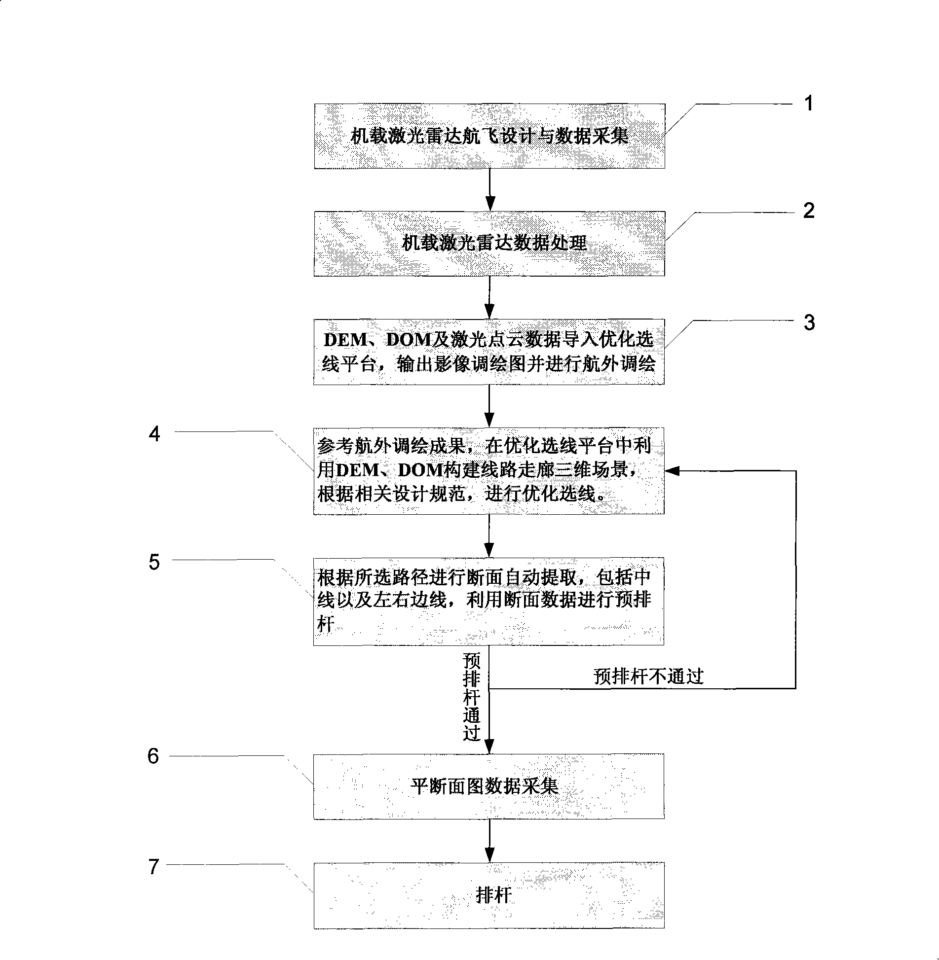
[0092] The following takes the Daxin-Nanning 500kV overhead power transmission line project in Guangxi Zhuang Autonomous Region as an example, according to figure 1 The workflow shown is detailed below:

[0093] Step 1: Airborne lidar flight design and data collection

[0094] 1. According to the preliminary design path plan and related regulations and specifications, use 1 / 10,000, 1 / 50,000 or other remote sensing satellite images with geographical positioning for flight design and airborne lidar data collection;

[0095] 2. Coordinate system design. Using the 1954 Beijing coordinate system, Gaussian projection, 3-degree zone. The elevation datum adopts the 1956 Yellow Sea elevation;

[0096] 3. DEM and DOM precision design. The DEM and DOM results must meet the 1 / 2000 scale accuracy requirement;

[0097] 4. Flight height design. According to the accuracy of DEM and DOM products, it is determined that the laser point interval is 2.5 meters, and the image resolution is n...


PUM


Abstract

The invention discloses an optimal route selection method for overhead transmission line route. Onboard lidar equipment is adopted to acquire laser point cloud data and aerial digital photo data of the transmission line route corridor range; the onboard lidar data is processed after the wave filtering and the sorting of the laser point cloud data, and the points of the ground surface are made into a digital elevation model with high precision; then data processing is carried out by utilizing the data of the digital elevation model with high precision and ortho-rectification is carried out to the aerial photo by utilizing the internal and external orientation elements of the aerial digital photo to generate digital orthophoto maps; through the overlying of the digital elevation model and the digital orthophoto maps, the tridimensional visualization of the transmission line route corridor can be realized to optimize the transmission line route selection; finally prearrangement of power pole and power pole arrangement are carried out according to the data of plane cross sections. The route selection platform of the invention has simple operation and lifelike tridimensional scene, thus being convenient for full roaming and multi-view observation and greatly improving the efficiency of the inner plane cross section survey operation. Compared with the optimal route selection technology based on the aerial photographing measuring method, the efficiency of the inner plane cross section survey operation can be improved by about 75 percent.

Description

technical field [0001] The invention belongs to the technical field of optimal line selection for overhead power transmission lines, namely an optimal line selection method for overhead power transmission lines based on airborne laser radar data, which is suitable for optimal line selection of overhead high-voltage transmission line engineering in the survey and design stage. Background technique [0002] At present, the optimal line selection of domestic overhead high-voltage transmission line projects (above 220kV level) is usually realized by aerial photogrammetry, that is, according to the route plan recommended by the line feasibility study or the preliminary design path plan, the three-dimensional image of the line corridor range is obtained through aerial photography For the image (if it is not a digital image, it is necessary to develop the photo negative and scan and digitize it), and then use the results of the image control measurement outside the aircraft to proce...

Claims


Application Information

Patent Timeline
IPC IPC(8): H02G1/02G01S17/89
Inventor 李新科黄文京吕健春王滋政阳锋曾陈黄伟张正均彭坚徐祖舰何勇波刘改进
Owner GUANGXI ELECTRIC POWER IND INVESTIGATION DESIGN & RES INST
Why Eureka
Try Eureka