A Maritime Precise Positioning Method Based on Elevation Constraint

A precise positioning and elevation technology, applied in satellite radio beacon positioning systems, instruments, measuring devices, etc., can solve the problems of low positioning accuracy and low positioning accuracy, and achieve the effect of shortening the convergence time and improving the solution accuracy.

Inactive Publication Date: 2021-12-07
TIANJIN UNIV
View PDF6 Cites 0 Cited by
  • Summary
  • Abstract
  • Description
  • Claims
  • Application Information

AI Technical Summary

Problems solved by technology

At present, maritime positioning mainly relies on GNSS (Global Navigation Satellite System). The main problem is that the positioning accuracy in the elevation direction is significantly lower than that in the plane direction.

Method used


Image

  • A Maritime Precise Positioning Method Based on Elevation Constraint
  • A Maritime Precise Positioning Method Based on Elevation Constraint
  • A Maritime Precise Positioning Method Based on Elevation Constraint

Examples


Embodiment Construction

[0030] In order to further understand the invention content, characteristics and effects of the present invention, the following examples are given, and detailed descriptions are as follows in conjunction with the accompanying drawings:

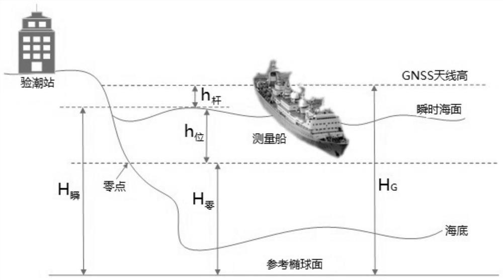
[0031] The present invention proposes a marine precision positioning method based on elevation constraints. The so-called elevation constraints refer to the water level observation data (h 位 ) as the basis, through the geodetic height (H 零 ), combined with the distance between the GNSS antenna phase center and the instantaneous sea surface (h 杆 ), the obtained GNSS antenna geodetic height data (H 观 ) of a set of GNSS antenna prior geodetic height data (H G ) is added to the conventional GNSS positioning calculation process. The purpose is to provide a solution to the current situation that the positioning accuracy of the elevation direction in offshore positioning is only about half of the plane accuracy, and improve the positioning accura...


PUM


Abstract

The invention discloses a sea precision positioning method based on elevation constraints. Based on the instantaneous sea surface geodetic data obtained from the water level data observed by the tide gauge station, the distance between the antenna phase center of the GNSS receiver and the instantaneous sea surface is calculated to generate The prior geodetic height data of the GNSS antenna phase center, and the prior geodetic height data are used to solve the constraints, so as to improve the positioning accuracy of the sea elevation direction. Compared with the conventional GNSS positioning algorithm, the method of the invention adds an elevation constraint condition, which can not only effectively improve the calculation accuracy of the elevation direction, but also significantly shorten the convergence time of the elevation direction.

Description

technical field [0001] The invention relates to marine survey technology, in particular to a method for precise positioning at sea based on elevation constraints. Background technique [0002] Offshore positioning is the basis of offshore survey operations. At present, maritime positioning mainly relies on GNSS (Global Navigation Satellite System). The main problem is that the positioning accuracy in the elevation direction is significantly lower than that in the plane direction. In addition, in order to carry out marine research, the tide gauge stations deployed along the coast can provide first-hand water level observation data, which lays the data foundation for the realization of this method. Contents of the invention [0003] The purpose of the present invention is to overcome the deficiencies in the prior art and provide a method for precise positioning at sea based on elevation constraints. In the conventional GNSS positioning calculation process, the GNSS antenna...

Claims


Application Information

Patent Timeline
Patent Type & Authority Patents(China)
IPC IPC(8): G01S19/48
CPCG01S19/48
Inventor 张安民刘荣霞张豪张雨侬侯泽北刘帅邸明伟丁峰徐唐进
Owner TIANJIN UNIV
Why Eureka
Try Eureka