Potential landslide identification method integrating DEM, optical remote sensing and deformation information
A technology of optical remote sensing and recognition methods, applied in character and pattern recognition, scene recognition, radio wave reflection/re-radiation, etc., can solve problems such as rapid identification of unfavorable large-scale potential landslides
Active Publication Date: 2019-08-13
CHANGAN UNIV
View PDF4 Cites 16 Cited by
- Summary
- Abstract
- Description
- Claims
- Application Information
AI Technical Summary
Problems solved by technology
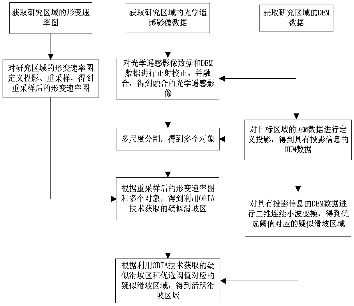
In the method of fusion of InSAR technology and optical remote sensing, it is necessary to construct a complex classification rule set, and it detects suspected landslides on the basis of large-scale deformation, and then extracts a single suspected landslide, which is not conducive to the analysis of large-scale potential landslides. Rapid identification, still misjudgments and missed judgments
Method used
View moreImage
Smart ImageViewing Examples
Examples
Embodiment
[0109] The experimental data of the present invention adopts real TerraSAR-X down-orbit data and WorldView-02 optical remote sensing image data. Among them, the TerraSAR-X down-orbit data is 19 scenes, and the WorldView-02 optical remote sensing image data is one scene, including panchromatic data with a resolution of 0.5m and multispectral data with a resolution of 2m, and the collection date is November 2015 29th;
Login to View More PUM
 Abstract
The invention belongs to the field of potential landslide identification, and provides a potential landslide identification method integrating DEM, optical remote sensing and deformation information,which specifically comprises the following steps: processing an SAR image in a research area to obtain a resampled deformation rate map; obtaining optical remote sensing image data and DEM data of theresearch area, and obtaining a plurality of objects according to the obtained optical remote sensing image data and DEM data of the research area; according to the resampled deformation rate map anda plurality of objects, processing to obtain a suspected landslide area obtained by utilizing an object-oriented classification technology; selecting a known landslide region and a known non-landslideregion in the research region to obtain a suspected landslide region corresponding to the preferred threshold value, and combining the suspected landslide region with the suspected landslide region obtained by using an object-oriented classification technology to obtain a potential landslide region. The method is simple to operate, the obtained suspected landslide area is more continuous and complete in space, and misjudgment and missed judgment of the landslide area are effectively reduced.
Description
technical field [0001] The invention belongs to the field of potential landslide identification, and in particular relates to a potential landslide identification method integrating DEM, optical remote sensing and deformation information. Background technique [0002] Landslides are a common natural disaster caused by engineering geological problems. The early identification of landslides is mainly based on conventional field map surveys or conventional engineering surveys. These methods mainly rely on the experience of professionals, which are not only time-consuming and laborious, but also have limited coverage. , but also need to invest a lot of human resources. However, optical remote sensing interpretation technology can identify landslides, although its coverage is large, and landslides can be identified through human-computer interaction; however, conventional optical remote sensing surveys can only provide semi-quantitative landslide identification results, and there...
Claims
Login to View More Application Information
Patent Timeline
 Patent Type & Authority Applications(China)
IPC IPC(8): G06T7/11G06K9/00G06K9/62G01S13/90
CPCG06T7/11G01S13/9023G01S13/9005G06T2207/30181G06T2207/10032G06T2207/10036G06T2207/20064G06V20/13G06F18/24
Inventor 赵超英荀张媛刘晓杰
Owner CHANGAN UNIV
Features
- R&D
- Intellectual Property
- Life Sciences
- Materials
- Tech Scout
- Unparalleled Data Quality
- Higher Quality Content
- 60% Fewer Hallucinations
Learn More Browse by: Latest US Patents, China's latest patents, Technical Efficacy Thesaurus, Application Domain, Technology Topic, Popular Technical Reports.
© 2025 PatSnap. All rights reserved.Legal|Privacy policy|Modern Slavery Act Transparency Statement|Sitemap|About US| Contact US: help@patsnap.com


