Ship-borne integrated navigation positioning method

A technology of integrated navigation and positioning methods, applied in the field of ship positioning, can solve the problems of lack of attitude information, satellite signal spoofing and interference, and positioning results are easily affected by multi-path effects, so as to achieve the effect of improving convenience

Active Publication Date: 2019-08-16
SHANGHAI MARITIME UNIVERSITY
View PDF10 Cites 5 Cited by
  • Summary
  • Abstract
  • Description
  • Claims
  • Application Information

AI Technical Summary

Problems solved by technology

Although the satellite positioning system can provide global and all-weather navigation, positioning and timing services for ships, because satellite signals are vulnerable to deception and interference, the update rate of satellite positioning data is low, and the positioning results are easily affected by multipath effec...

Method used


Image

  • Ship-borne integrated navigation positioning method
  • Ship-borne integrated navigation positioning method
  • Ship-borne integrated navigation positioning method

Examples


Embodiment Construction

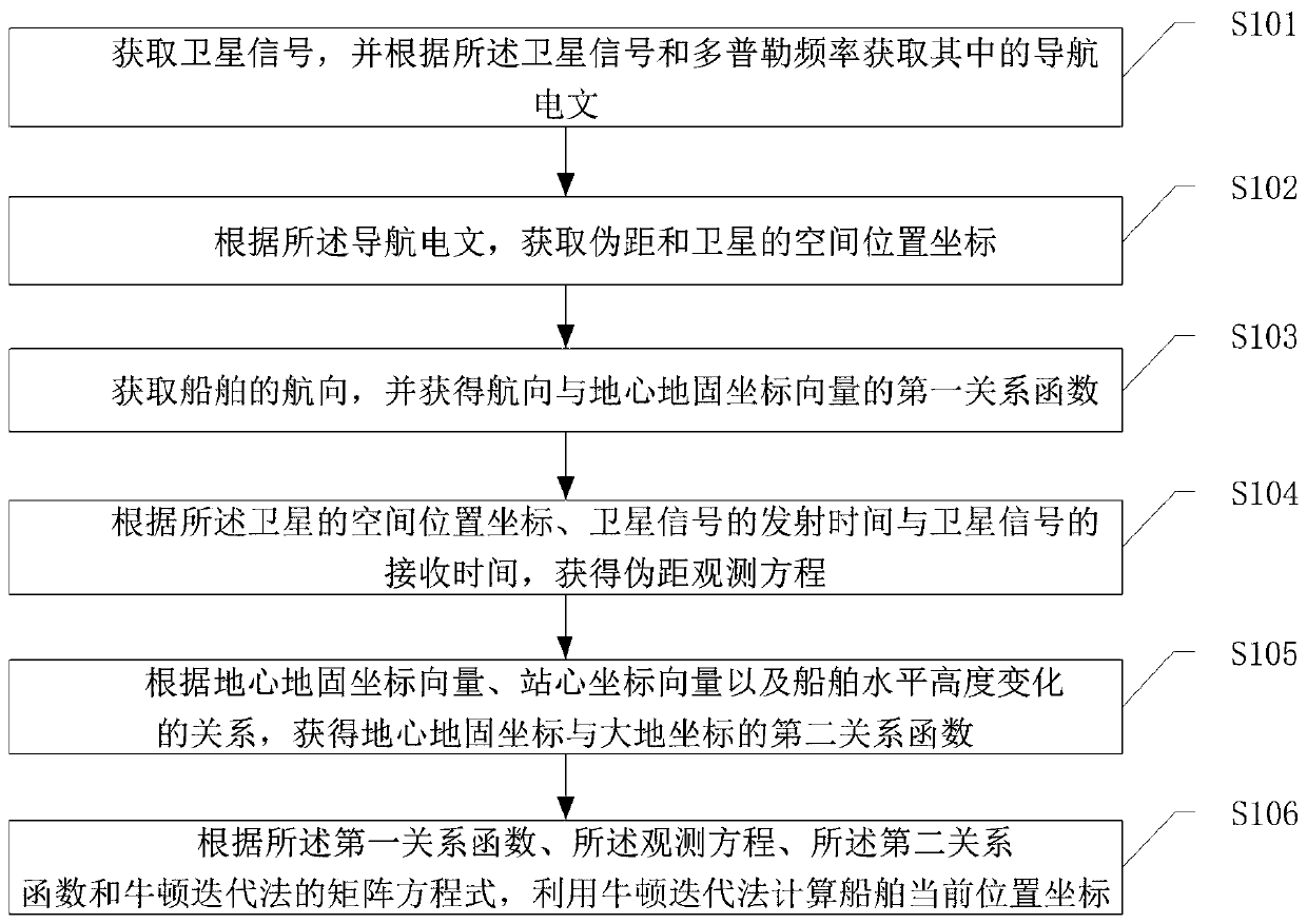
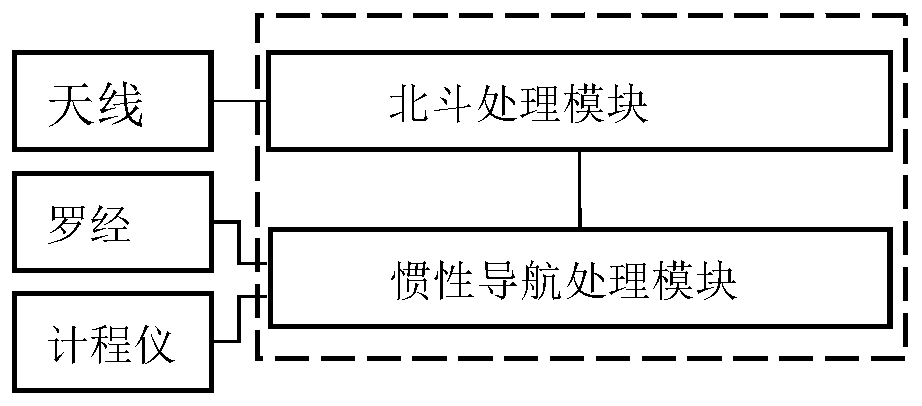
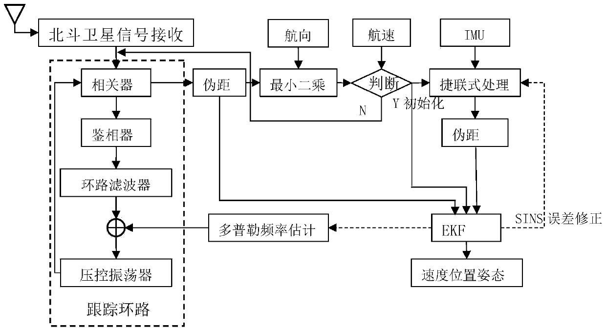
[0050] Embodiments of the present invention are described below through specific examples, and those skilled in the art can easily understand other advantages and effects of the present invention from the content disclosed in this specification. The present invention can also be implemented or applied through other different specific implementation modes, and various modifications or changes can be made to the details in this specification based on different viewpoints and applications without departing from the spirit of the present invention.

[0051] see Figure 1-2 . It should be noted that the diagrams provided in this embodiment are only schematically illustrating the basic idea of ​​the present invention, and only the components related to the present invention are shown in the diagrams rather than the number, shape and shape of the components in actual implementation. Dimensional drawing, the type, quantity and proportion of each component can be changed arbitrarily d...


PUM


Abstract

The invention discloses a ship-borne integrated navigation positioning method which comprises the steps of: firstly, acquiring a navigation message in a visible satellite signal; according to the navigation message, acquiring a pseudo-range between a visible satellite and a ship-borne receiver and spatial position coordinates of the visible satellite; acquiring a heading of a ship, and acquiring afirst relation function of the heading and an ECEF (Earth Centered Earth Fixed) coordinate vector; according to the spatial position coordinates of the visible satellite, emission time of the satellite signal and receiving time of the satellite signal, acquiring a pseudo-range observation equation; acquiring a second relation function of ECEF coordinates and geodetic coordinates; and according tothe first relation function, the observation equation, the second relation function and a matrix equation of a Newton iteration method, calculating current position coordinates of the ship by utilizing the Newton iteration method. According to the embodiment of the invention, a real-time position and speed of the ship are accurately and stably output, and in a case that the number of satellites is not smaller than 2, positioning calculation can be directly carried out, so that convenience of calculation is improved.

Description

technical field [0001] The invention relates to the technical field of ship positioning, in particular to a ship-borne integrated navigation and positioning method. Background technique [0002] At present, ships mainly use the Global Positioning System (GPS) to achieve positioning while sailing, and use radar and automatic identification system (Automatic Identification System, AIS) to assist ships to avoid obstacles. Although the satellite positioning system can provide global and all-weather navigation, positioning and timing services for ships, because satellite signals are vulnerable to deception and interference, the update rate of satellite positioning data is low, and the positioning results are easily affected by multipath effects and there is no attitude information. Therefore, the ship cannot completely rely on the satellite positioning system when positioning. And at present, many ships are equipped with log and compass for drivers to observe, but they lack the ...

Claims


Application Information

Patent Timeline
IPC IPC(8): G01S19/47
CPCG01S19/47
Inventor 刘卫顾明星胡媛王胜正
Owner SHANGHAI MARITIME UNIVERSITY
Why Eureka
Try Eureka