Portable runway calibration equipment

A portable, runway technology, used in satellite radio beacon positioning systems, instruments, measuring devices, etc., to solve the problems of inconvenience and inconvenience

Pending Publication Date: 2019-09-06
成都北斗星云科技有限公司
View PDF2 Cites 2 Cited by
  • Summary
  • Abstract
  • Description
  • Claims
  • Application Information

AI Technical Summary

Problems solved by technology

[0003] Existing runway calibration equipment needs power supply for power supply, which requires a very long cable, which is inconvenient during use; existing runway calibration equipment is wired transmission, and cables need to be prepared at any time for connection, and cannot be used at any time

Method used


Image

  • Portable runway calibration equipment
  • Portable runway calibration equipment

Examples


Embodiment Construction

[0024] The present invention will be further described in detail below in conjunction with the accompanying drawings and embodiments.

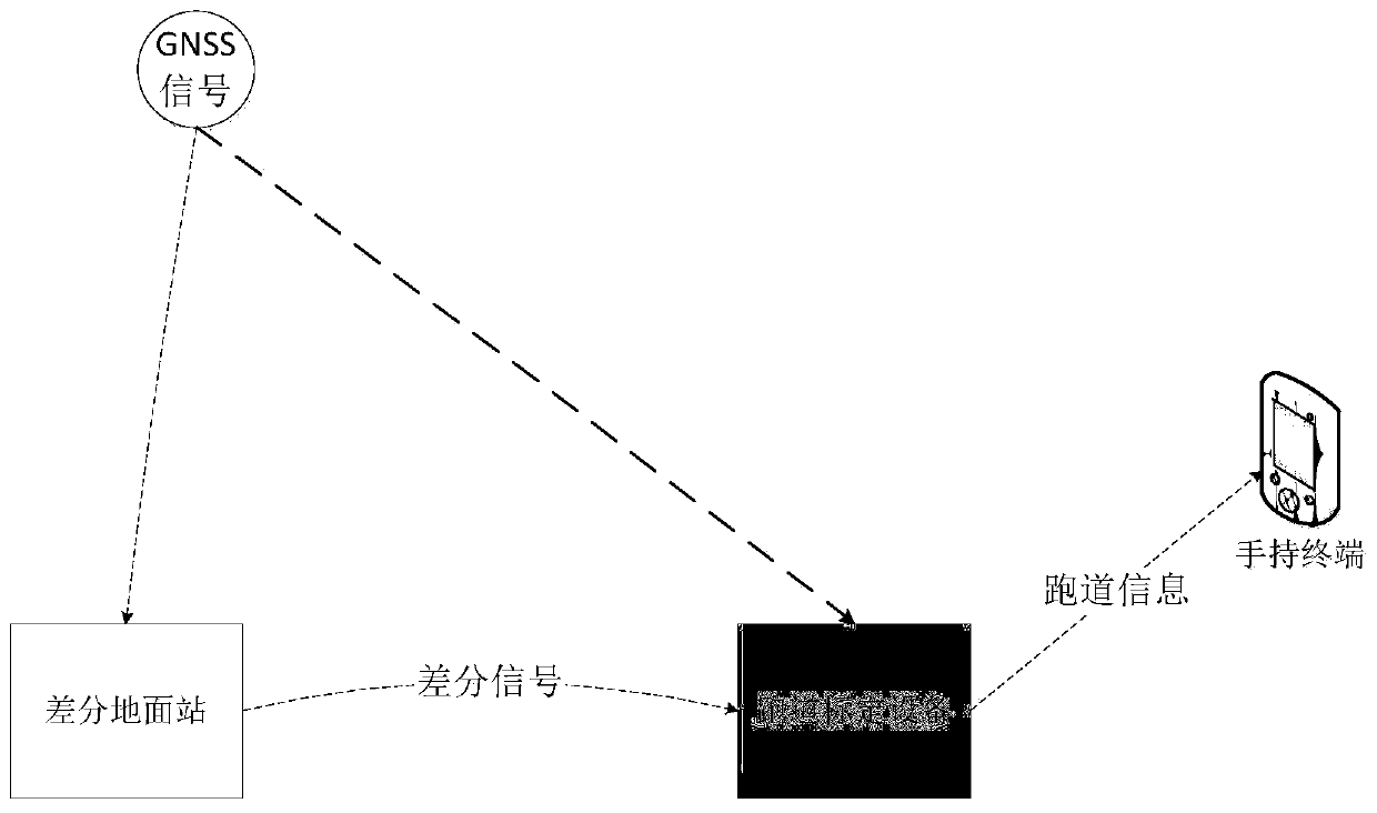
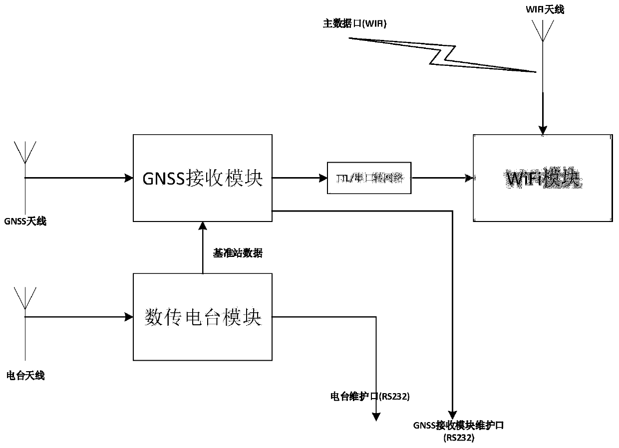
[0025] Such as figure 1 As shown, the portable runway calibration equipment receives satellite signals through the satellite navigation antenna, and performs RTK calculation by tracking the satellite signals and the differential information sent by the receiving equipment through the satellite navigation OEM board (reference "Global Positioning System (GPS) Theory and Practice", "GPS Reference Station System Theory and Practice") measure the position information of the coordinate points, send them through WiFi, and transmit the coordinate information of the calibration points to the display interface. The device consists of three parts: GPS module, radio module and WIFI module. The GPS module obtains the positioning information and calculates it with the base station information. The radio module obtains the base station information and forwar...


PUM


Abstract

The invention provides portable runway calibration equipment, which comprises a GNSS antenna, a GNSS receiving module, a radio station antenna, a digital transmission radio station module, a TTL/serial-to-network module, a WiFi module and a WiFi antenna, wherein the GNSS antenna is connected with the GNSS receiving module; the radio station antenna is connected with the digital transmission radiostation module; reference station information is used for recording latitude and longitude coordinate information of a reference station; the digital transmission radio station module is connected with the GNSS receiving module; the GNSS receiving module is used for performing RTK solution based on positioning information and the reference station information, so as to obtain latitude and longitude coordinate information of a mobile station; the GNSS receiving module is connected with the TTL/serial-to-network module, and the TTL/serial-to-network module is connected with the WiFi module; andthe WiFi antenna is connected with the WiFi antenna, and is used for transmitting the latitude and longitude coordinate information of the mobile station. The portable runway calibration equipment solves the problem of completing rapid calibration of a runway course and a central coordinate point when a UAV does not yet perform or needs to perform an emergent landing on a temporarily selected runway in a newly deployed airport.

Description

technical field [0001] The invention relates to the technical field of calibration equipment, in particular to a portable runway calibration equipment, which is used for positioning and calibration of runways before flight, and provides accurate runway information for aircraft. Background technique [0002] The Beidou satellite navigation system is a global satellite positioning and communication system (BDS) developed by China itself. It is the third mature satellite navigation system after the US Global Positioning System (GPS) and Russia's GLONASS. The system consists of a space terminal, a ground terminal and a user terminal. It can provide all kinds of users with high-precision, high-reliability positioning, navigation, and timing services all-weather and all-weather around the world, and has the ability to communicate with short messages. Regional navigation, positioning and timing capabilities, the positioning accuracy is better than 20m, and the timing accuracy is be...

Claims


Application Information

Patent Timeline
Patent Type & Authority Applications(China)
IPC IPC(8): G01S19/42
CPCG01S19/42
Inventor 龙隆强飞飞
Owner 成都北斗星云科技有限公司
Why Eureka
Try Eureka