SINS self-aided navigation method for deep diving manned submersible

A technology of manned submersibles and navigation methods, which is applied in the field of underwater navigation and positioning of manned submersibles, and can solve problems such as the influence of multipath effects, the correlation between positioning accuracy and operating distance, etc.

Active Publication Date: 2019-10-18
SOUTHEAST UNIV
View PDF3 Cites 8 Cited by
  • Summary
  • Abstract
  • Description
  • Claims
  • Application Information

AI Technical Summary

Problems solved by technology

However, the acoustic positioning system not only requires the surface support mother ship or pre-deployed special equipment, but also is susceptible to multipath effects and the positioning accuracy is related to the working distance
In addition, although SINS has the advantages of

Method used


Image

  • SINS self-aided navigation method for deep diving manned submersible
  • SINS self-aided navigation method for deep diving manned submersible
  • SINS self-aided navigation method for deep diving manned submersible

Examples


Embodiment Construction

[0072] The technical solutions of the present invention will be further described below in conjunction with the accompanying drawings and embodiments.

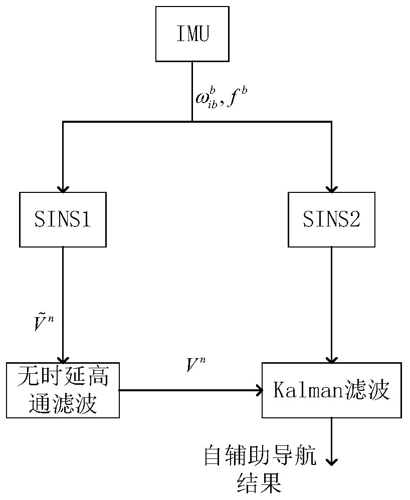
[0073] A kind of SINS self-assisted navigation method of deep submersible manned submersible described in the present invention, structural frame is as follows figure 1 shown, including the following steps:

[0074] Step 1: Use the angular motion and linear motion measurements provided by the inertial measurement unit (IMU) on the manned submersible as the input of the strapdown inertial navigation system (SINS), execute the navigation solution algorithm twice in parallel, and output two sets of identical The navigation parameters, that is, attitude, velocity and position, so as to obtain two identical sets of strapdown inertial navigation SINS, namely SINS1 and SINS2.

[0075] The inertial measurement unit (IMU) includes three gyroscopes orthogonal to each other and three accelerometers orthogonal to each other, and the gyro...


PUM


Abstract

The invention discloses a SINS self-aided navigation method for a deep diving manned submersible. The method comprises the following steps: 1, taking angular motion and linear motion measurement provided by an inertial measurement unit (IMU) on the manned submersible as input of a strapdown inertial navigation system (SINS), executing two navigation calculation algorithms in parallel, and outputting two groups of identical navigation parameters, thus obtaining two sets of identical strapdown inertial navigation systems SINS1 and SINS2; 2, performing frequency difference characteristic analysison a horizontal speed output by the SINS1 in the step 1; 3, designing a high-pass time-delay-free digital filter, and filtering out a low-frequency speed error component contained in the horizontal speed output by the SINS1, thereby obtaining the real horizontal speed of the manned submersible; and 4, commonly constructing speed matching integrated navigation through Kalman filtering and the SINS2 by utilizing the real horizontal speed obtained in the step 3, thus obtaining an integrated navigation result of which the positioning error is not accumulated along with time. According to the method, auxiliary speed information under a navigation system can be obtained, and the positioning errors are not accumulated along with time.

Description

technical field [0001] The invention belongs to the technical field of underwater navigation and positioning of a manned submersible, in particular to a SINS self-assisted navigation method for a deep submersible manned submersible. Background technique [0002] With the development of underwater navigation sensor technology and algorithms, new underwater vehicles are constantly emerging, and new underwater operation tasks can be realized. However, both Global Positioning System (GPS) and Doppler Velocimetry (DV) are unavailable in this section of water far from the sea surface or seabed, making mid-water navigation still one of the severe challenges facing underwater navigation. Currently, acoustic positioning systems and inertial measurement units (IMUs) are the only sensors available for mid-water XY navigation. [0003] For deep-diving manned submersibles, taking into account the precious underwater operation time, obtaining accurate landing and exit points is crucial t...

Claims


Application Information

Patent Timeline
IPC IPC(8): G01C21/16
CPCG01C21/165Y02A90/30
Inventor 刘锡祥刘贤俊王艺晓马晓爽刘剑威
Owner SOUTHEAST UNIV
Why Eureka
Try Eureka