Method for pre-warning forest fire based on satellite remote sensing data

A technology of satellite remote sensing data and forest fires, applied in the field of remote sensing, can solve the problems of insufficient accuracy of forest fire risk forecasting and achieve high accuracy

Inactive Publication Date: 2019-10-25
北京中科锐景科技有限公司
View PDF10 Cites 17 Cited by
  • Summary
  • Abstract
  • Description
  • Claims
  • Application Information

AI Technical Summary

Problems solved by technology

[0004] This application provides a forest fire early warning method based on satellite remote sen

Method used


Image

  • Method for pre-warning forest fire based on satellite remote sensing data
  • Method for pre-warning forest fire based on satellite remote sensing data
  • Method for pre-warning forest fire based on satellite remote sensing data

Examples


Embodiment Construction

[0025] In order to make the purpose, technical solution and advantages of the present application clearer, the technical solution of the present application will be clearly and completely described below in conjunction with specific embodiments of the present application and corresponding drawings. Apparently, the described embodiments are only some of the embodiments of the present application, rather than all the embodiments. Based on the embodiments in this application, all other embodiments obtained by persons of ordinary skill in the art without making creative efforts belong to the scope of protection of this application.

[0026] The technical solutions provided by various embodiments of the present application will be described in detail below in conjunction with the accompanying drawings.

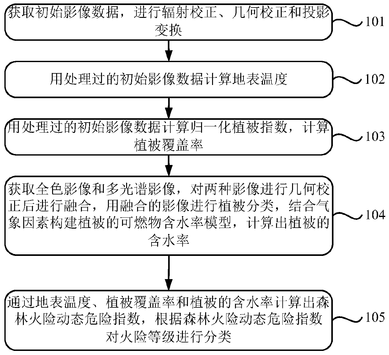
[0027] figure 1 It is a schematic diagram of a forest fire early warning method based on satellite remote sensing data.

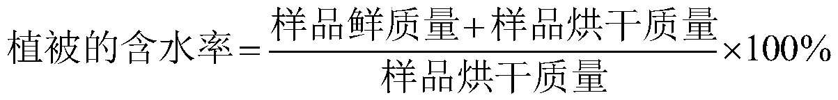
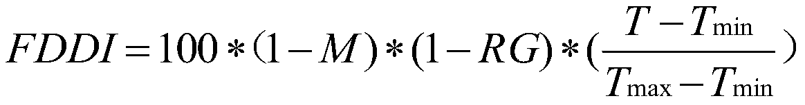
[0028] The embodiment of the present application propose...


PUM


Abstract

The invention discloses a method for pre-warning forest fire based on satellite remote sensing data, and solves the problem that existing forest fire danger forecasting is insufficient in precision. The method comprises the following steps: obtaining image data, and carrying out radiation correction, geometric correction and projection transformation; using processed image data to calculate surface temperature; using processed image data to calculate normalized differential vegetation index so as to calculate vegetation coverage rate; obtaining a panchromatic image and a multispectral image, carrying out geometric correction on the panchromatic image and the multispectral image, fusing the panchromatic image and the multispectral image for vegetation classification, constructing combustible moisture content models of different types of vegetations in combination with meteorological factors, and calculating the moisture contents of different types of vegetations; calculating dynamic hazard indexes of forest fire through the surface temperature, the vegetation coverage rate and the moisture contents of different types of vegetations, and classifying fire danger classes according to the dynamic hazard indexes of forest fire. According to the method, the precision of a combustible moisture content model is much higher than that of a model determined through remote sensing satelliteparameters directly.

Description

technical field [0001] This application relates to the field of remote sensing, in particular to a method for early warning of forest fires based on satellite remote sensing data. Background technique [0002] The existing forest fire warning scheme mainly uses satellite remote sensing data to invert surface temperature, calculate vegetation coverage, calculate moisture content of combustibles, and finally calculate forest fire risk index by formula. The disadvantage of the existing technology is that the moisture content of combustibles retrieved from satellite remote sensing data does not consider the factor of vegetation type. [0003] The occurrence of forest fires largely depends on the moisture content of combustibles, and the type of vegetation has a great influence on the moisture content of combustibles. The forest fire risk index calculated without considering the vegetation type has low accuracy. Contents of the invention [0004] The present application provid...

Claims


Application Information

Patent Timeline
IPC IPC(8): G08B17/00G08B17/12G06Q10/04G06Q50/26G06T3/00G06T5/00G06T5/50G06T7/00
CPCG06Q10/04G06Q50/265G06T3/005G06T5/006G06T5/50G06T7/0002G06T2207/10036G06T2207/20221G06T2207/30188G08B17/005G08B17/125
Inventor 柴向停李富成
Owner 北京中科锐景科技有限公司
Why Eureka
Try Eureka