Semantic edge dominated high-resolution remote sensing image segmentation method

A remote sensing image and edge technology, applied in image analysis, image enhancement, image data processing, etc.

Inactive Publication Date: 2019-12-10
ZHEJIANG UNIV OF TECH
View PDF5 Cites 5 Cited by
  • Summary
  • Abstract
  • Description
  • Claims
  • Application Information

AI Technical Summary

Problems solved by technology

However, judging from the currently available patents / documents, there is no real method for practical image segmentation based on this improved edge, and this is exactly what the present invention hopes to focus on and promote

Method used


Image

  • Semantic edge dominated high-resolution remote sensing image segmentation method
  • Semantic edge dominated high-resolution remote sensing image segmentation method
  • Semantic edge dominated high-resolution remote sensing image segmentation method

Examples


Embodiment Construction

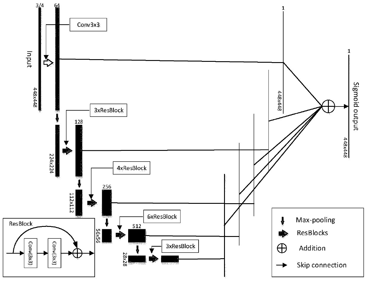
[0032] figure 1 It is a schematic diagram of the edge-dominated high-resolution remote sensing image segmentation method, in which the generation of the edge intensity map is divided into two parts: the front and the back. The previous part is data model preparation, using deep learning methods to prepare edge models, according to data and task requirements, you can directly use pre-trained models or prepare samples for retraining, including three steps: data preparation, network design, and model preparation. Then the edge strength prediction map can be obtained after calculation of the production data by the prepared data model. The latter part is the generation of segmentation results. According to the segmentation requirements, a polygonal vector map of ground objects with precise boundaries and correct topology is generated, including the process of thinning boundaries, extending boundaries, and vectorizing boundary lines.

[0033] A high-resolution remote sensing image ...


PUM


Abstract

The invention discloses a semantic edge dominated high-resolution remote sensing image segmentation method. The method comprises the steps of data acquisition, network design, model preparation, edgeproduction, morphological post-processing and vectorization. Multi-scale fusion is formed by utilizing the feature learning capability of a convolutional neural network and pooling operation, and ground object edges conforming to visual features are extracted from a remote sensing image. A pre-training edge model or a retraining model based on a local manual sketching result can be adopted to correspond to an unsupervised method and a supervised method in a segmentation task respectively. Relatively accurate and complete ground object boundaries are formed through edge refinement and extensionconnection, and the boundaries are vectorized to form ground object polygons required by segmentation. The ground object polygon generated by the method can be basically matched with the visual boundary of the ground object on the image, and therefore most of over-segmentation and under-segmentation phenomena in a traditional segmentation object are overcome, and effective support is provided forground object fine form determination, type identification and large-scale information extraction.

Description

technical field [0001] The present invention relates to a remote sensing image processing technology and a remote sensing image information extraction method, in particular, to the segmentation of remote sensing images and its implementation method for depth semantic edges. The present invention is applicable to the supervision or Unsupervised segmentation. Background technique [0002] With the continuous improvement of the spatial resolution of remote sensing images, especially the popularization of aerial images such as drones in recent years, spatial objects are reflected in the images in great detail. How to quickly and accurately divide these data Objects have always been a key concern of remote sensing production and application personnel. In the previous national land surveys and national censuses, map delineation has always been the heaviest office work, and image segmentation as a solution has always been a research hotspot, especially in the object-oriented analy...

Claims


Application Information

Patent Timeline
Patent Type & Authority Applications(China)
IPC IPC(8): G06T7/12
CPCG06T7/12G06T2207/10032G06T2207/20081G06T2207/20084G06T2207/20132
Inventor 夏列钢张雄波吴炜杨海平
Owner ZHEJIANG UNIV OF TECH
Why Eureka
Try Eureka