Configurable front-end pure JS map animation set implementation method based on vector data

A technology of vector data and implementation method, applied in the field of WebGIS, can solve the problems of basic animation data update, animation effect cannot be extended, no animation available, etc., to achieve the effect of easy expansion, reduction of unnecessary operations, and reduction of performance consumption

Active Publication Date: 2019-12-24
吉奥时空信息技术股份有限公司
View PDF7 Cites 3 Cited by
  • Summary
  • Abstract
  • Description
  • Claims
  • Application Information

AI Technical Summary

Problems solved by technology

[0005] The technical problem to be solved by the present invention is to propose a vector data-based configurable front-end pure JS map animation set implementation method, the present invention is a pure JS animation set implementation method, based on the CMD development mode, can be directly referenced and loaded into most cmd development mode systems, and it is very easy to expand, and the configuration is relatively simple, The reading action of data has also been integrated into the module configuration

Method used


Image

  • Configurable front-end pure JS map animation set implementation method based on vector data
  • Configurable front-end pure JS map animation set implementation method based on vector data
  • Configurable front-end pure JS map animation set implementation method based on vector data

Examples


Embodiment 1

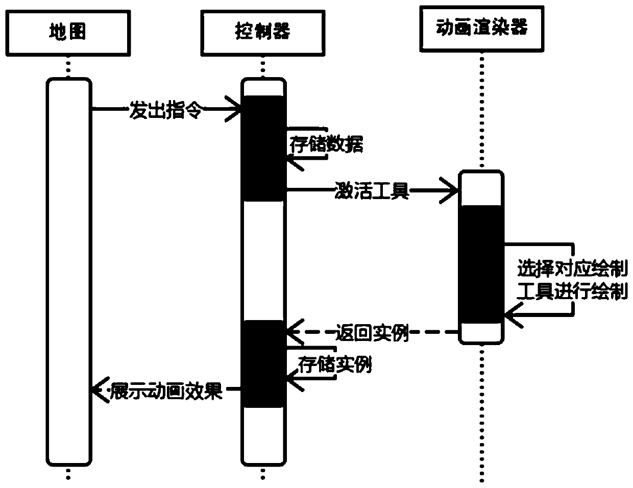
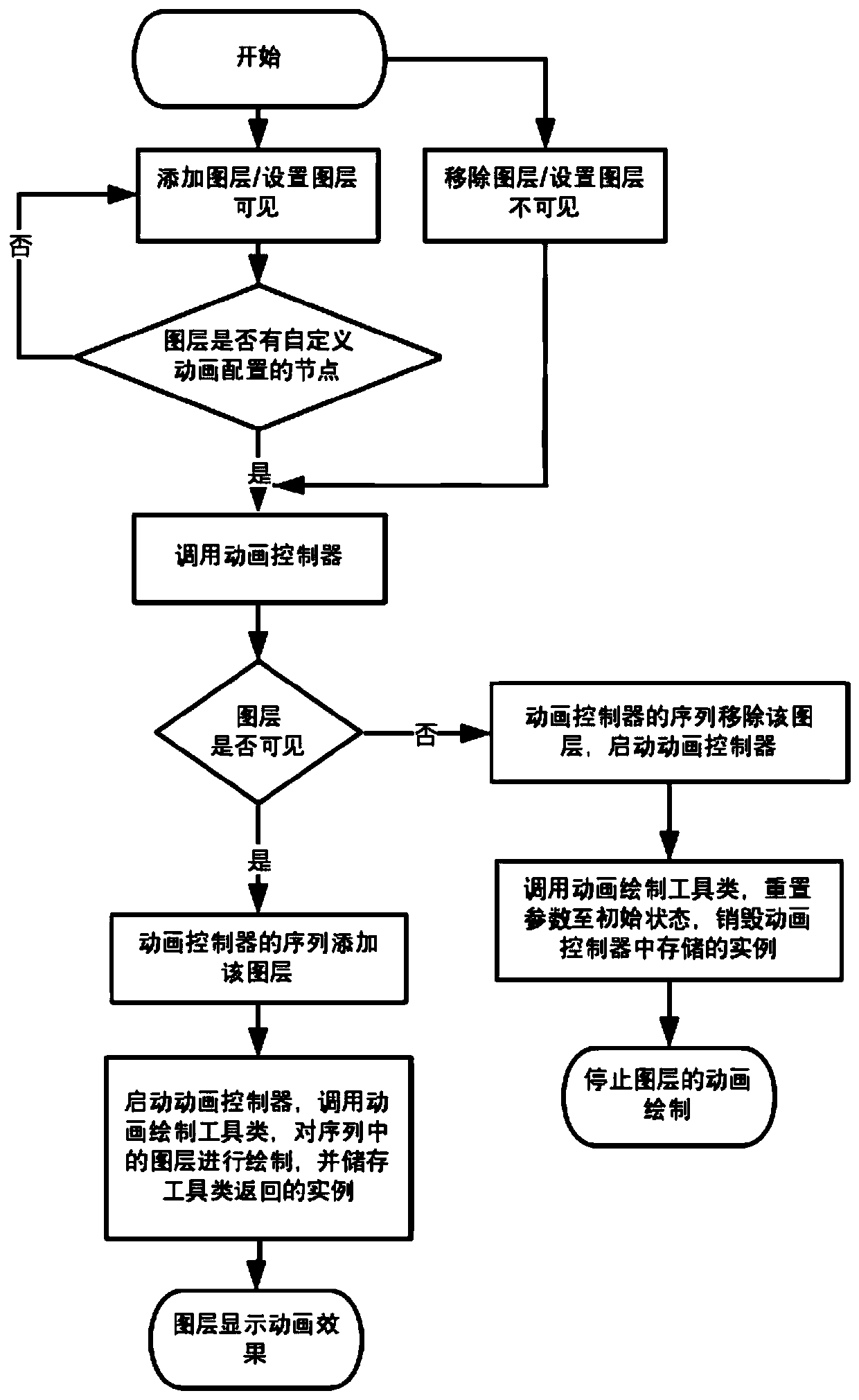
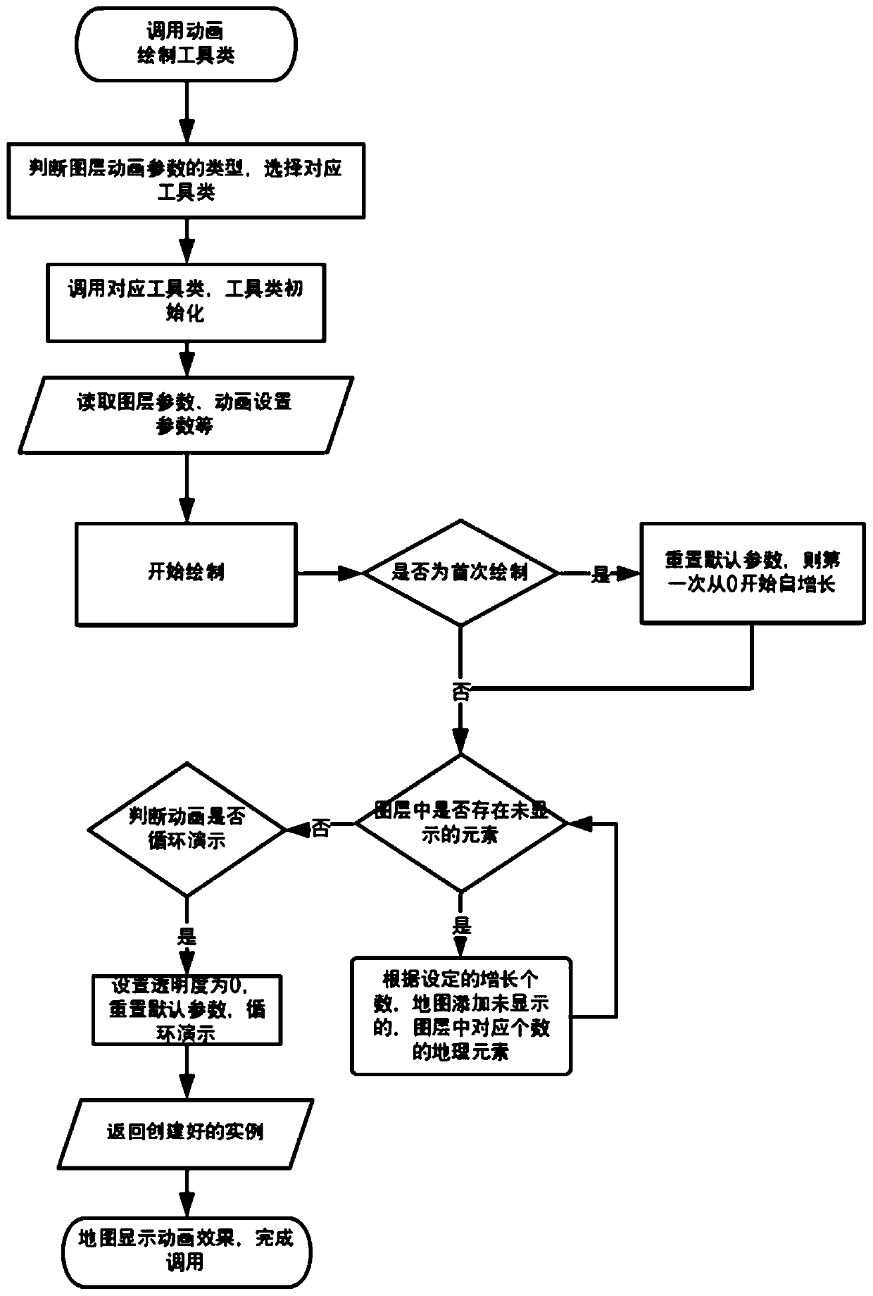
[0055] refer to Figure 5 , when layer 1 already exists in the map (animation effect is line element breathing effect blur-line), to add layer 2 (animation effect is line element self-increasing growth-line), set the animation property (JSON type), it will be in When the layer is loaded, it is loaded into the controller, and the animation is saved as the configuration content of the animation object. When layer 2 is added to the map, if it is judged that the layer is visible and animation exists, it will be loaded into the controller sequence. The configuration description of the Animation of layer 1 and layer 2 is shown in the table below.

[0056] Starts the animation controller, iterates over all layers in the sequence, and calls the animation renderer. During the traversal process, the visibility of the layer will be judged, and if it is visible, the corresponding animation renderer will be called according to the configuration in animation. For example, when traversing...


PUM


Abstract

The invention discloses a configurable front-end pure JS map animation set implementation method based on vector data. According to the invention, the implementation is based on W3C suggestions; the method is based on the refreshing frequency of a browser screen. The GIS vector data in the CMD mode and the animation display effect in the WebGIS map can be achieved only through the configuration form, the animation display effect comprises the display forms of constant-speed extension, flickering, constant-speed sorting and the like, all the forms can be combined at will, configuration is easyto operate and edit, and animation types and animation related attributes are included. According to the method, firstly, the defect that data cannot dynamically appear in the GIS field is overcome, and qualitative change from nothing to nothing is achieved; secondly, indirect introduction is changed into direct implementation, unnecessary operation is reduced, and performance consumption is reduced; moreover, for diversification of current data visualization requirements and requirements for animation of GIS data, a conventional CMD mode is adopted, a modular development form and a deep-in shallow-out design are adopted, and complexity is simplified into simple configuration, so that the method is easy to transplant, start and expand.

Description

technical field [0001] The invention relates to the technical field of WebGIS, more specifically, to a method for realizing a configurable front-end pure JS map animation set based on vector data. Background technique [0002] In the existing front-end WebGIS technology, EchartGL can realize the chart animation effect of third-party WebGIS map data (hereinafter referred to as chart animation, the animation realized by the present invention is called map animation), and its disadvantages are as follows: [0003] 1. In this technology, the map is embedded and connected to the bottom layer of the chart display, so the map animation must be displayed below the chart animation; [0004] 2. In the case of a clear development trend of the visualization system, the skills of chart animation in this technology meet some of the visualization needs, but its animation effect is limited, it cannot be extended, the configuration is complicated and the effect is general, and it cannot meet...

Claims


Application Information

Patent Timeline
Patent Type & Authority Applications(China)
IPC IPC(8): G06T13/80G06F16/29
CPCG06T13/80G06F16/29Y02D10/00
Inventor 杨玲黄宇林洋孙超俊
Owner 吉奥时空信息技术股份有限公司
Why Eureka
Try Eureka