BIM geological model modeling method based on database and GIS technology

A modeling method and geological model technology, applied in database management systems, geographic information databases, 3D modeling, etc., can solve the problem of limiting the freedom and availability of 3D geological modeling, limiting the scope of 3D geological models, and inability to intuitively understand boreholes. General area, etc.

Active Publication Date: 2019-12-24
SHANGHAI GEOTECHN INVESTIGATIONS & DESIGN INST
View PDF5 Cites 2 Cited by
  • Summary
  • Abstract
  • Description
  • Claims
  • Application Information

AI Technical Summary

Problems solved by technology

This process not only needs to collect and sort out the geological drilling data of the project, but also limits the scope of the 3D geological model. During the implementation process, it is impossible to intuitively understand the approximate area of ​​the recorded drilling, which greatly limits the freedom of 3D geological modeling. sex and usability

Method used


Image

  • BIM geological model modeling method based on database and GIS technology
  • BIM geological model modeling method based on database and GIS technology
  • BIM geological model modeling method based on database and GIS technology

Examples


Embodiment

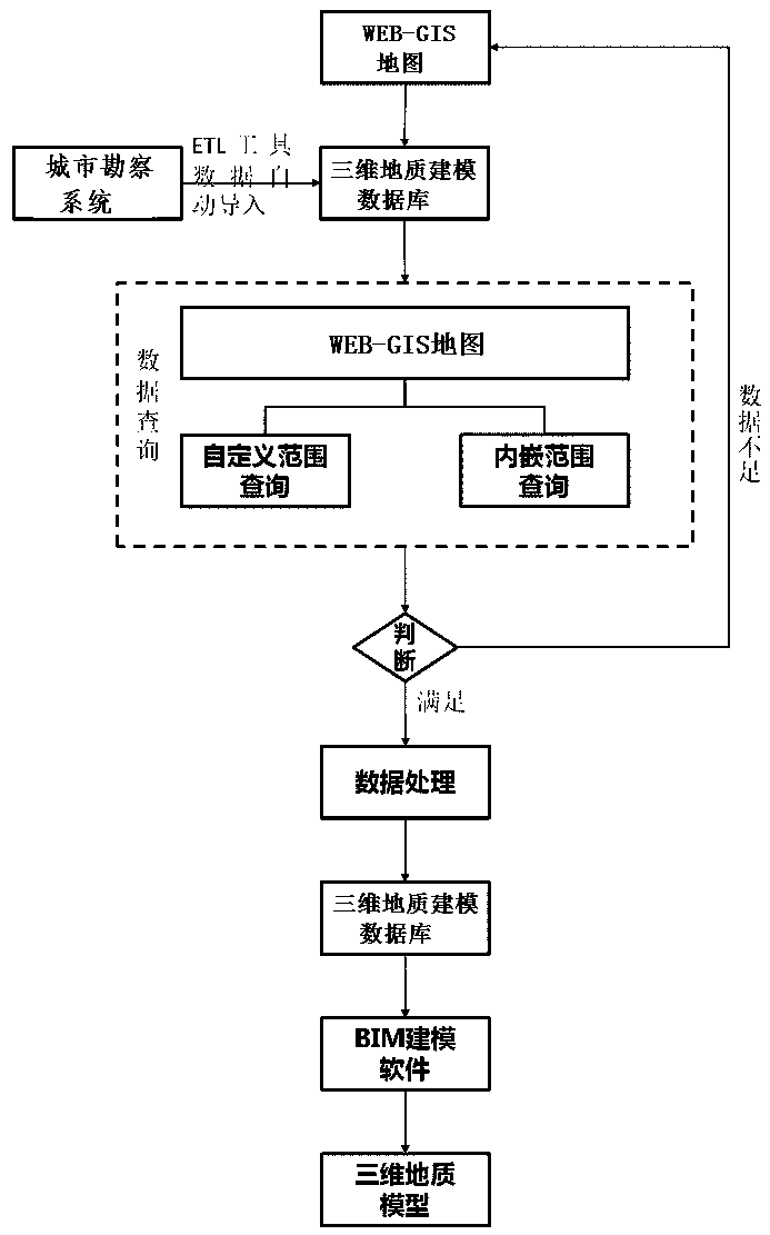
[0031] Example: such as Figure 1-6 As shown, the present embodiment specifically relates to a BIM geological model modeling method based on database and GIS technology, and the modeling method includes the following steps:

[0032] (S1) The geological drilling data of various areas in the city are entered and stored in the urban survey system, and the geological drilling data in the urban survey system are extracted, transformed, and loaded into the 3D geological modeling database through ETL tools, so that The data in the 3D geological modeling database is consistent with the data in the urban survey system; if the ETL tool cannot obtain data from the urban survey system, the geological drilling data can be entered into the 3D geological modeling database.

[0033] (S2) Coordinate association of the three-dimensional coordinates of each geological borehole in the three-dimensional geological modeling database with the WEB-GIS map, so that each geological borehole can be dis...


PUM


Abstract

The invention discloses a BIM geological model modeling method based on a database and a GIS technology. According to the modeling method, the geological drilling data in a three-dimensional geological modeling database and the geological drilling data in an urban investigation system are kept consistent by utilizing an ETL tool or an input mode, and meanwhile, the three-dimensional coordinates ofthe geological drilling data are associated with a WEB-GIS map, and the corresponding geological drilling holes are displayed in a range drawn by the user on the WEB-GIS map, so that a three-dimensional geological model in the range is outputted through a BIM modeling platform. The method has the advantages that a cloud technology, a Web-GIS technology, a database technology and a geological modeling technology are comprehensively utilized to visualize the geological drilling data query process, the customization of the three-dimensional geological modeling range is achieved through a GIS space calculation method, then the rapid, efficient and free three-dimensional geological modeling is completed by means of a data interface transmission mode and a three-dimensional geological modelingplug-in, and the usability and plasticity of a three-dimensional geological model are improved.

Description

technical field [0001] The invention belongs to the technical field of automatic modeling, and in particular relates to a BIM geological model modeling method based on database and GIS technology. Background technique [0002] With the continuous maturity and development of BIM technology and the promotion of national policies, the demand for 3D models is becoming more and more urgent in engineering construction projects. The 3D model not only has complete spatial geometric information, but also carries all the information during the entire construction project process. Due to this "snowball" effect, the 3D model becomes more and more valuable with the development of the project stage. In addition, in the future smart city architecture, a 3D model with complete information will be an essential element. At present, most of the 3D models of engineering projects only include architectural structure models and do not include 3D geological models. However, accurate 3D geological...

Claims


Application Information

Patent Timeline
Patent Type & Authority Applications(China)
IPC IPC(8): G06T17/05G06F16/29G06F16/25G09B29/00
CPCG06T17/05G06F16/29G06F16/254G09B29/006G09B29/005
Inventor 彭艾鑫蔡国栋许杰黄永进杨石飞孙莉尚颖霞邰俊徐良义
Owner SHANGHAI GEOTECHN INVESTIGATIONS & DESIGN INST
Why Eureka
Try Eureka