Electronic map tour guide method special for tourist attractions

An electronic map and scenic spot technology, applied in the field of scenic spot management, can solve problems such as limited functions, too large scenic spots, and ignorance of historical background, and achieve a good sense of immersion and high interest

Inactive Publication Date: 2020-01-17
成都中科大旗软件股份有限公司
View PDF5 Cites 12 Cited by
  • Summary
  • Abstract
  • Description
  • Claims
  • Application Information

AI Technical Summary

Problems solved by technology

Usually, the area of ​​the scenic spot that people visit is relatively large, and it is also a place that is unfamiliar to tourists. Therefore, people will always encounter some troubles when going out to visit the scenic spots, such as unfamiliar routes of scenic spots, not knowing their location when the scenic spots are too large, history The background is not understood, the text description is too abstract, etc., all of which will affect the experience of tourists during the

Method used


Image

  • Electronic map tour guide method special for tourist attractions
  • Electronic map tour guide method special for tourist attractions

Examples


Embodiment 1

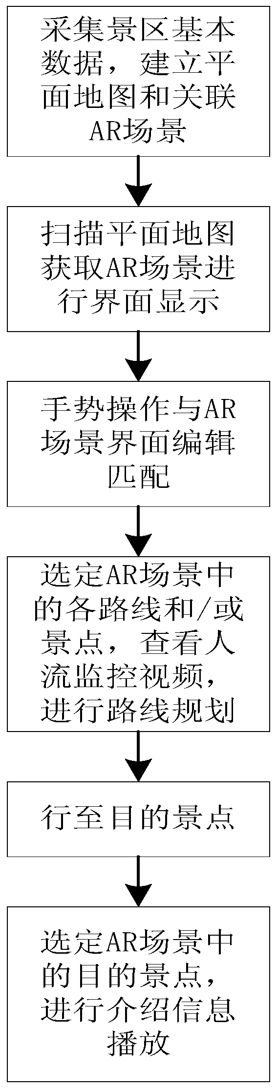
[0033] like figure 1 As shown, a special electronic map guide method for tourist attractions includes the following steps:

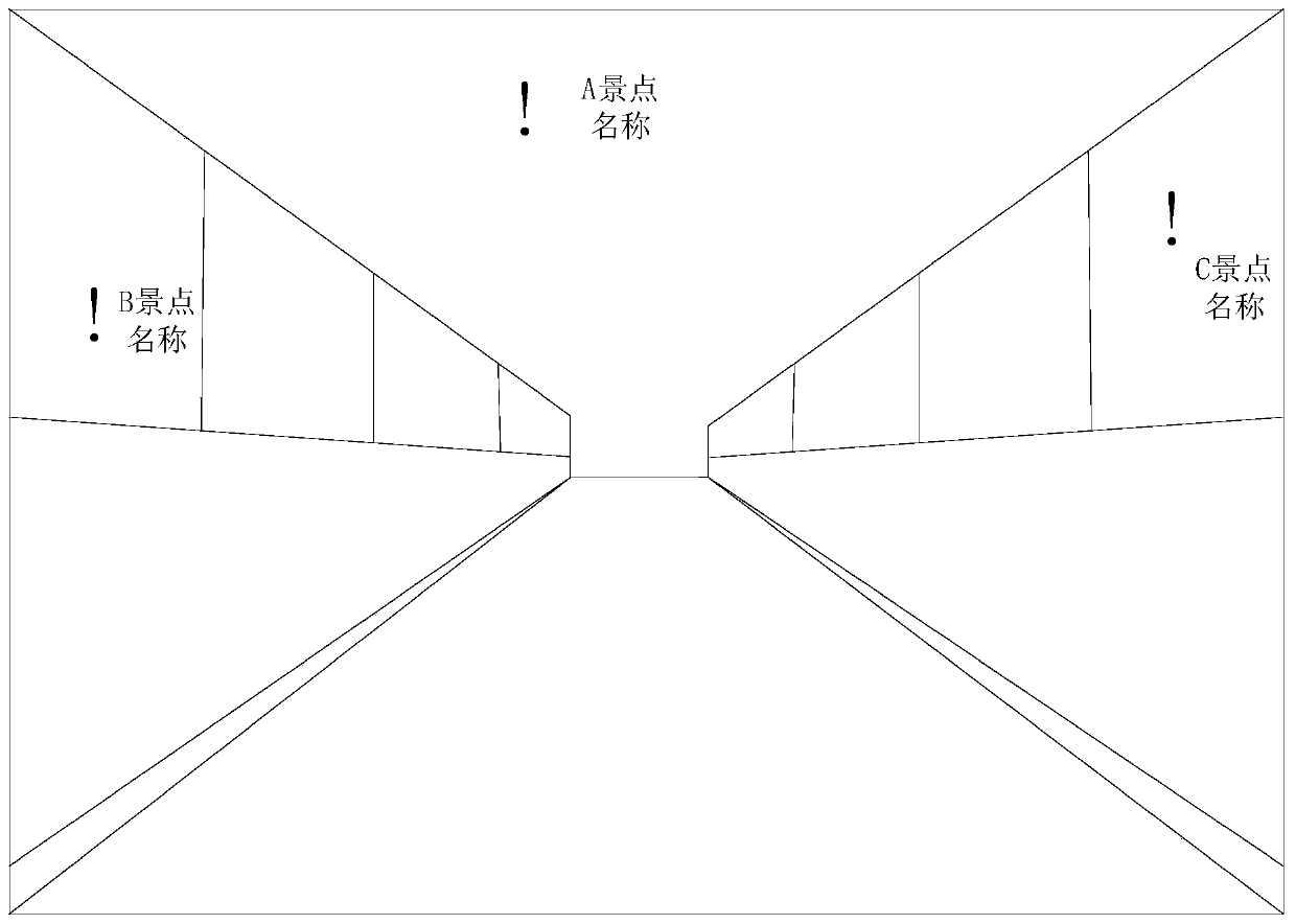
[0034] Step 1: Collect the basic data of the scenic spot and AR scene data of each scenic spot, establish a flat map of the scenic spot and the associated AR scene according to the basic data of the scenic spot, and demarcate the tourist routes and scenic spots of the scenic spot in the AR scene, and use the spatial coordinates in the space of the AR scene. Establish a calibration point associated with each tourist route and scenic spot in each scenic spot; establish a database to store the introduction information of each scenic spot in the basic data of the scenic spot, including the real image, voice commentary and text introduction information, and compare the introduction information with the corresponding scenic spots in the AR scene. Fixed-point association; establish a live video channel to obtain real-time people flow monitoring video of each to...

Embodiment 2

[0054] As an optimization of the solution in Embodiment 1, a back-end service platform is set up in the scenic spot, and through the back-end service platform, AR scene construction, monitoring video live channel management, database management, data integration processing, etc. Smart mobile terminals, such as mobile phones, tablet computers, etc., scan the plane map, enter the data channel to access the back-end service platform to obtain the AR scene data of the scenic spot, and then use the special APP or public account of the scenic spot to access the AR scene data on the smart mobile terminal. After the display processing is performed, the AR scene interface is displayed, and then the route planning and scenic spot introduction information can be played on the intelligent mobile terminal through gesture operations.

Embodiment 3

[0056] As an optimization of the scheme of Example 2, a special internal network is set up in the scenic area. Tourists use smart mobile terminals to access the data access channel through the internal network of the scenic area, quickly access the back-end service platform, complete the data transmission of AR scenes, and effectively improve the data transmission. Efficiency, to prevent the failure of access to the back-end service platform or the inability of data transmission due to too many tourists and congestion of the external network, and improve the experience of tourists.

[0057] The intranet is also a local area network. The computers in the intranet use the NAT (Network Address Translation) protocol to access the Internet through a public gateway. Computers on the intranet can send connection requests to other computers on the Internet, but other computers on the Internet cannot send connection requests to computers on the intranet. NAT (Network Address Translator)...


PUM


Abstract

The invention discloses an electronic map tour guide method special for tourist attractions, and the method comprises the following steps: collecting basic data of the tourist attraction, and establishing a tourist attraction plane map and an associated AR scene; scanning the scenic spot plane map, and obtaining an associated AR scene for interface display; performing adaptive matching on the gesture operation and AR scene interface editing content; selecting a touring route and/or scenic spot calibrated in the AR scene through gesture operation, obtaining a real-time people stream monitoringvideo corresponding to the route and/or scenic spot, and planning the touring route; driving to a target scenic spot in the scenic spot according to the planned touring route; and selecting a calibration scenic spot corresponding to a target scenic spot in the AR scene through gesture operation, and obtaining introduction information of the corresponding target scenic spot for playing and displaying. The AR tour guide map brought by the live-action can be provided for tourists, so that the tourists can select routes and scenic spots after checking the live-action of the routes and the scenic spots, and scenic spot explanation with parallel characters, sounds and images is provided for the tourists.

Description

technical field [0001] The invention relates to the technical field of scenic spot management, in particular to a method for guiding a tourist scenic spot with an electronic map. Background technique [0002] With the progress of the times, people's material life has been greatly enriched, most people began to pursue spiritual enjoyment, and traveled to various regions to experience the customs and customs to satisfy their spiritual enjoyment after work. Under normal circumstances, the scenic spots that people visit and visit are relatively large and unfamiliar to tourists. Therefore, people will always encounter some troubles when they go out to visit scenic spots, such as unfamiliar scenic spots, unfamiliar scenic spots, large scenic spots and do not know their location, history The background is not understood, the text description is too abstract, etc., which will affect the experience of tourists in the process of visiting and traveling. Nowadays, in order to facilitat...

Claims


Application Information

Patent Timeline
IPC IPC(8): G06F3/01G06F3/0484G06Q10/04G06Q50/14
CPCG06F3/017G06F3/0484G06Q10/047G06Q50/14
Inventor 周道华杨陈曾俊洪江彭容黄维李武鸿刘瑞东张明娟许江泽吴婷婷付志华刘杰詹飞程武彬杨眉
Owner 成都中科大旗软件股份有限公司
Why Eureka
Try Eureka