Road edge detection system and method based on laser radar and fan-shaped space segmentation

A laser radar and space segmentation technology, applied in the direction of instruments, character and pattern recognition, computer components, etc., can solve problems that are easy to cause artificial features, the impact of extraction results, and single clustering features

Active Publication Date: 2020-02-11
SUN YAT SEN UNIV
View PDF4 Cites 37 Cited by
  • Summary
  • Abstract
  • Description
  • Claims
  • Application Information

AI Technical Summary

Problems solved by technology

[0003] In the prior art, a method of using gradient filtering to obtain roadside candidate points has been proposed, but this method is not effective in dealing with obstacles blocking the roadside, roadside shape changes, and slope changes, because the scanning of multi-line radar emission lines The radii are not the same, and the characteristics of the roadside reflection points at different distances from the car are also different. Therefore, re-scanning the roadside, analyzing the results of obstacle recognition, and clustering are more stable choices; This method is used to segment point clouds and extract roadside point sets according to the distance from the vehicle. However, this method only finds out the gradient change points closest to the vehicle, and the clustering features are single. Large data, poor robustness; there is also a method of extracting candidate roadside feature points using a d

Method used


Image

  • Road edge detection system and method based on laser radar and fan-shaped space segmentation
  • Road edge detection system and method based on laser radar and fan-shaped space segmentation
  • Road edge detection system and method based on laser radar and fan-shaped space segmentation

Examples


Embodiment 1

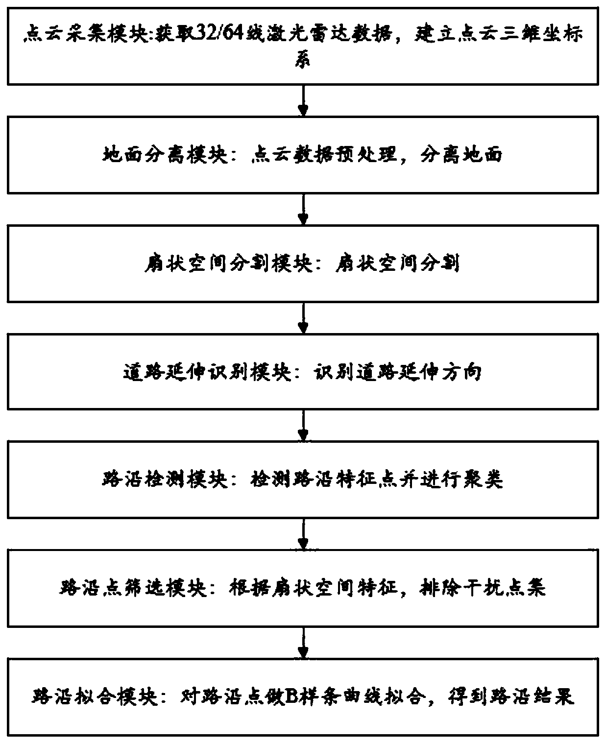
[0076] Such as figure 1 As shown, a roadside detection system based on laser radar and fan space segmentation, including:

[0077] The point cloud acquisition module is used to scan the surrounding environment of the vehicle through 32 / 64 line lidar, collect and process the point cloud data of the surrounding environment, and convert the point cloud data with spatial coordinates, reflection brightness and radar ring number to local coordinates In the system, output each frame of data to the ground separation module;

[0078] Ground separation module: used to extract the road pavement of the current point cloud set from a frame of point cloud data. The road pavement refers to the surface composed of the points closest to the ground of all objects in the point cloud space, and the ground point cloud set is output To the road edge detection module;

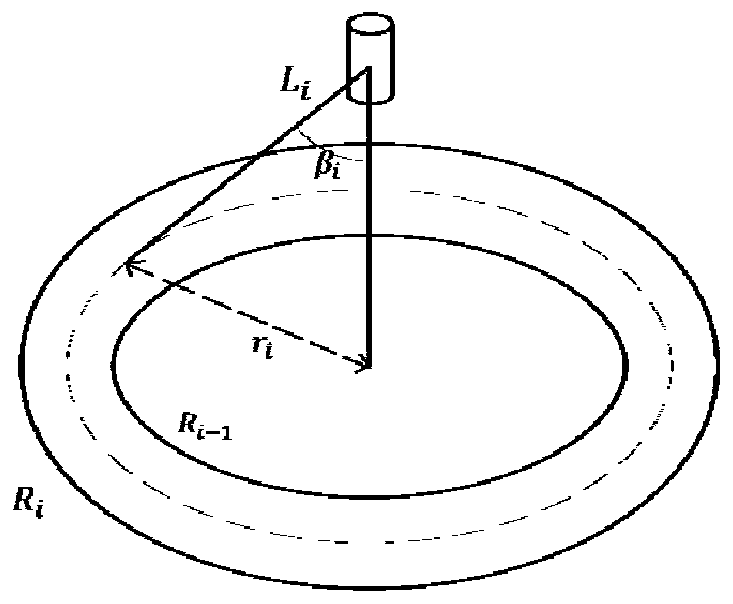
[0079] Fan-shaped space segmentation module: it is used to divide the space in the three-dimensional coordinates into different f...

Embodiment 2

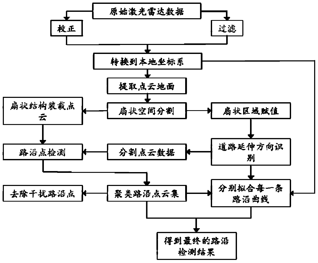
[0086] Such as Figures 2 to 7 As shown, a roadside detection method based on laser radar and fan-shaped space segmentation, using the roadside detection system described in Embodiment 1, specifically includes the following steps:

[0087] S1. Use the point cloud acquisition module to make the lidar scan the surrounding environment of the vehicle, obtain the reflection point cloud data, convert it to the local coordinate system for a certain degree of correction, and estimate the measurement accuracy range according to the number of radar lines;

[0088] S2. Using the ground separation module and using the sampling consistency segmentation algorithm to extract the ground point cloud set from the processed point cloud data;

[0089] S3. Using the fan-shaped space segmentation module, according to the characteristics of the laser radar reflection point cloud, calculate the segmentation parameters, and divide the space in the three-dimensional coordinates into different fan-shape...


PUM


Abstract

The invention relates to a road edge detection system and method based on laser radar and fan-shaped space segmentation. The method comprises the steps of 1, a laser radar scanning the surrounding environment of a vehicle to obtain reflection point cloud information and convert the reflection point cloud information into a locally constructed three-dimensional coordinate system; 2, preprocessing the point cloud data, and separating and extracting ground data in each frame of point cloud; 3, dividing the space in the coordinate system into fan-shaped structural bodies according to the data characteristics of the laser radar and the point cloud, and identifying the road extension direction according to the ground information and the fan-shaped structural bodies; 4, extracting road edge candidate points in the point cloud by using a parallel road edge retrieval algorithm; 5, clustering the road edge candidate points, and eliminating an interference point set according to fan-shaped spatial features; and 6, performing B spline curve fitting on the finally determined road edge point to obtain a road edge detection result. The method is high in adaptability, capable of adapting to roadsof various shapes and reducing the influence of obstacles, high in precision and reduction degree, high in reliability and low in error rate.

Description

technical field [0001] The invention belongs to the technical field of automatic driving, and more specifically relates to a roadside detection system and method based on lidar and fan-shaped space segmentation. Background technique [0002] With the development of unmanned driving industry technology, the perception algorithm of lidar has become a research hotspot. As a sensor for unmanned vehicles, lidar has the advantages of high data dimension, accurate depth information, fast response frequency and high detection accuracy. [0003] In the prior art, a method of using gradient filtering to obtain roadside candidate points has been proposed, but this method is not effective in dealing with obstacles blocking the roadside, roadside shape changes, and slope changes, because the scanning of multi-line radar emission lines The radii are not the same, and the characteristics of the roadside reflection points at different distances from the car are also different. Therefore, r...

Claims


Application Information

Patent Timeline
IPC IPC(8): G06K9/00G06K9/46G06K9/62
CPCG06V20/588G06V10/464G06F18/23
Inventor 孔繁校陈龙
Owner SUN YAT SEN UNIV
Why Eureka
Try Eureka