
Out-of-city road extraction method and device based on remote sensing images

A technology of road extraction and remote sensing images, which is applied in the field of remote sensing information processing, can solve problems such as unachievable effects, avoid the loss of detailed information, be easy to apply in engineering, and deepen the network depth

Inactive Publication Date: 2020-02-18
BEIJING UNIV OF CHEM TECH
View PDF8 Cites 12 Cited by
  • Summary
  • Abstract
  • Description
  • Claims
  • Application Information

AI Technical Summary

Problems solved by technology

However, in general, these techniques cannot achieve fully satisfactory results when extracting roads outside the city

Method used


Image

  • Out-of-city road extraction method and device based on remote sensing images
  • Out-of-city road extraction method and device based on remote sensing images
  • Out-of-city road extraction method and device based on remote sensing images

Examples


Embodiment Construction

[0045] The application will be further described in detail below in conjunction with the accompanying drawings and embodiments. It should be understood that the specific embodiments described here are only used to explain related inventions, rather than to limit the invention. It should also be noted that, for the convenience of description, only the parts related to the related invention are shown in the drawings.

[0046] It should be noted that, in the case of no conflict, the embodiments in the present application and the features in the embodiments can be combined with each other. The present application will be described in detail below with reference to the accompanying drawings and embodiments.

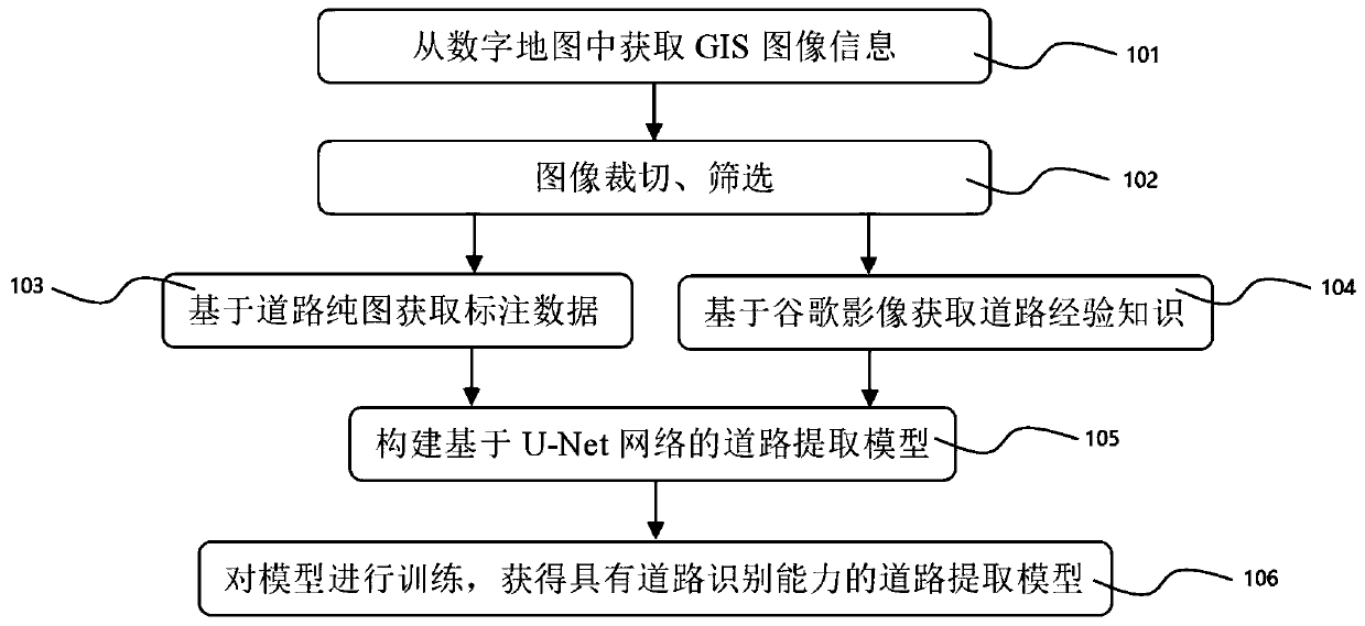
[0047] refer to figure 1 , figure 1 It shows a schematic flow of the road extraction model construction method according to the first embodiment of the present application, and the road extraction model is especially used for road extraction in areas such as suburban areas,...


PUM


Abstract

The invention provides an out-of-city road extraction method and device based on a remote sensing image, and the method comprises the steps: obtaining GIS image information from a digital map, and generating mark data and training / testing data; constructing an initial road extraction network model based on a U-Net network; training the initial network model by using the mark data and the training / testing data to obtain a road extraction model with road recognition capability; and detecting a remote sensing image by using the road extraction model, and automatically extracting a road target. According to the invention, the improved U-Net network is constructed, so that the accuracy of urban road extraction by using the remote sensing image is improved.

Description

technical field [0001] The present application relates to the technical field of remote sensing information processing, in particular to remote sensing image processing technology, and in particular to a method and device for extracting road information outside a city based on remote sensing images. Background technique [0002] In recent years, my country's remote sensing technology has developed rapidly, and has been widely used in areas such as urban planning, resource mining, military affairs, water conservancy, pollution control, and emergency relief. For example, in wartime, some highway sections can be used as road airports, and mastering road airports is of great significance to air force operations. For another example, during emergency relief, especially in rural areas, finding a suitable road can improve the efficiency of search and rescue and reduce the waste of resources. [0003] Although my country's navigation and digital map technology has developed relativ...

Claims


Application Information

Patent Timeline
Patent Type & Authority Applications(China)
IPC IPC(8): G06K9/00G06K9/62G06N3/04G06N3/08
CPCG06N3/08G06V20/182G06N3/045G06F18/214
Inventor 徐其志郭梦瑶张帆
Owner BEIJING UNIV OF CHEM TECH
Learn More