Method and device for online optimization of inertial navigation parameters in the cloud

An optimal parameter and parameter technology, applied in the field of inertial navigation parameter optimization, can solve problems such as single type of test terminal, long time period for parameter tuning, long time period for mass production of inertial navigation products, etc., to achieve rich terminal types and reduced quantity The effect of improving production cycle and tuning efficiency

Active Publication Date: 2022-02-08
QIANXUN SPATIAL INTELLIGENCE INC
View PDF7 Cites 0 Cited by
  • Summary
  • Abstract
  • Description
  • Claims
  • Application Information

AI Technical Summary

Problems solved by technology

[0004] The disadvantage of traditional inertial navigation parameter tuning is that an expensive high-precision POS system is required as a reference, the type of test terminal is single, and the time period from data collection to parameter tuning is long, resulting in a long time period for mass production of final inertial navigation products

Method used


Image

  • Method and device for online optimization of inertial navigation parameters in the cloud
  • Method and device for online optimization of inertial navigation parameters in the cloud
  • Method and device for online optimization of inertial navigation parameters in the cloud

Examples


Embodiment 1

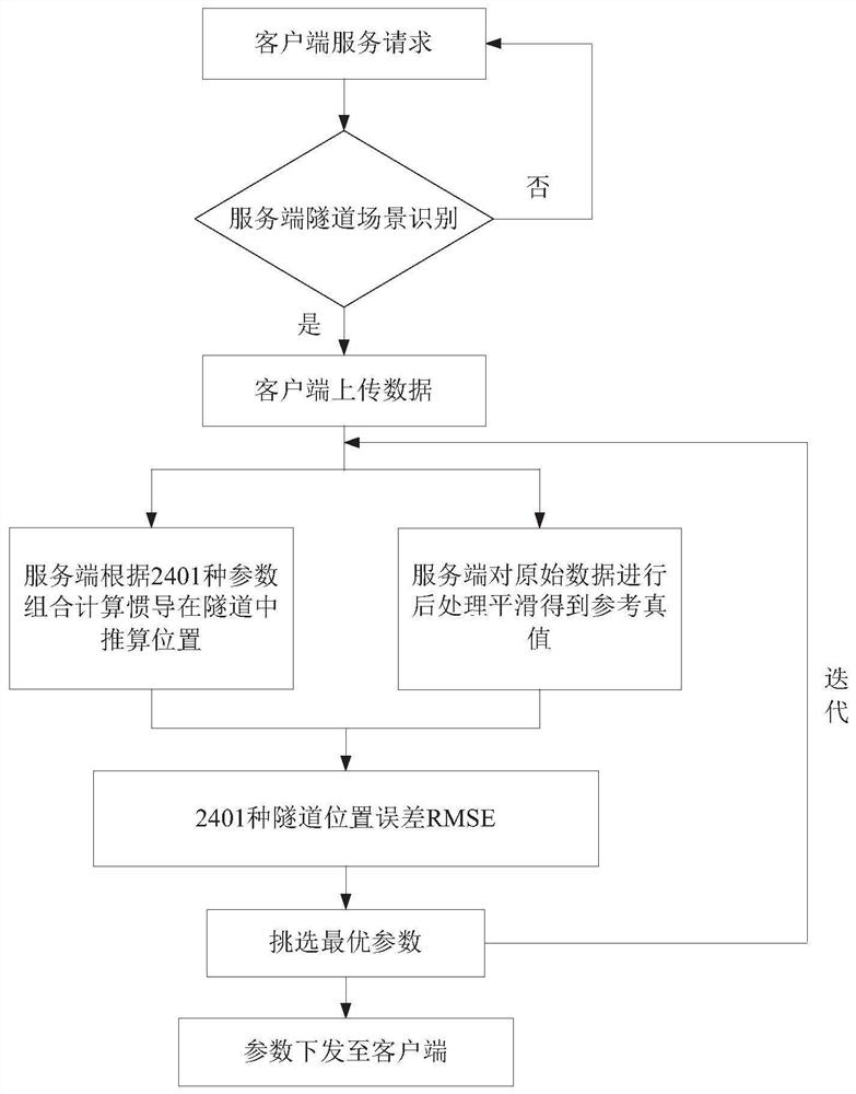
[0013] figure 1 It is a flow chart of the cloud-based online optimization inertial navigation method of the present invention, comprising the following steps:

[0014] The client reports the location every 15 seconds to make a service request. The server matches the reported location with the preset geographic fence. If it recognizes that the client is in the tunnel scene, it notifies the client to start uploading data. If it recognizes that it is not in the tunnel scene Do nothing.

[0015] The server runs the algorithm library according to the parameter combination to process the tunnel scene data reported by the client, and obtains the position estimated by the inertial navigation in the tunnel. At the same time, the server runs GNSS (Global Navigation Satellite System, Global Navigation Satellite System)+INS on the reported tunnel scene data (Inertial Navigation System, inertial navigation system) post-processing smoothing algorithm to obtain the reference true value, com...

Embodiment 2

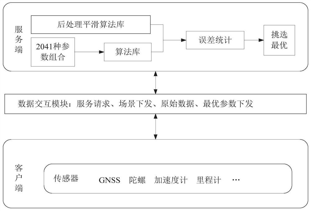
[0027] The present invention also provides a cloud online optimization inertial navigation device, such as figure 2 As shown, the device includes: a client, a data interaction module and a server.

[0028] The client makes a service request through the data interaction module every 15 seconds, that is, reports the location information (latitude and longitude), and the server searches according to the location reported by the client to confirm whether the client has entered the tunnel scene area. Send the scene mode to the client. At this time, the client starts to upload GNSS data, gyroscope and accelerometer data, and odometer vehicle speed data, and stops the data upload function when the client is not in the tunnel scene area. The server uses the collected raw data to run the server algorithm library according to 2401 parameter combinations to obtain the position calculated by inertial navigation in the tunnel under different parameter combinations. At the same time, the G...

Embodiment 3

[0031] The present invention also provides a memory, the memory stores a computer program, and the computer program is executed by the processor as follows:

[0032] The client reports the location to the server for service request;

[0033] The server judges whether the client has entered the tunnel scene area, and if it enters the tunnel scene area, it will notify the client to start uploading data to the server, otherwise the client will continue to report the location to the server for service requests;

[0034] The server processes the data uploaded by the client according to the parameter combination, and obtains the estimated position of the inertial navigation in the tunnel, and at the same time, the server processes the uploaded data to obtain the reference truth value of the tunnel;

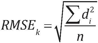
[0035] The position error of the inertial navigation system in the tunnel is obtained by comparing the estimated position with the reference true value, and the parameter combination corr...


PUM


Abstract

The present invention provides a method and device for online optimization of inertial navigation parameters in the cloud. The method includes the following steps: the client reports the location to the server for service request; the server judges whether the client enters the tunnel scene area, and if the The region informs the client to start uploading data to the server, otherwise the client continues to report the location to the server for service request; the server processes the data uploaded by the client according to the parameter combination, and obtains the estimated position of the inertial navigation in the tunnel, and at the same time the server Process the uploaded data to obtain the reference true value of the tunnel; compare the estimated position with the reference true value to obtain the position error of the inertial navigation in the tunnel, select the parameter combination corresponding to the smallest position error as the optimal parameter and send it to the client . The invention shortens the mass production period of products, reduces the time for tuning parameters of inertial navigation from 72 hours to 5 hours, and improves the tuning efficiency by more than 14 times.

Description

technical field [0001] The invention relates to the technical field of inertial navigation parameter optimization, in particular to a method and device for online optimization of inertial navigation parameters in the cloud. Background technique [0002] In the development process of inertial navigation products, it is necessary to evaluate the error parameters of inertial devices (gyroscopes, accelerometers), mainly including bias instability and random walk. Generally, the zero-bias instability and random walk parameters can be obtained through the allan variance evaluation method in the laboratory environment, but the final application environment of the product is different from the indoor laboratory environment, so it is necessary to collect vehicle test data outdoors and install high-precision POS (Position Orittention System, position and heading system) reference system is used as the benchmark true value, using the scene where the satellite signal is lost, such as tu...

Claims


Application Information

Patent Timeline
Patent Type & Authority Patents(China)
IPC IPC(8): G01S19/47G01C21/16
CPCG01S19/47G01C21/165
Inventor 刘川川
Owner QIANXUN SPATIAL INTELLIGENCE INC
Why Eureka
Try Eureka