A forest fire guidance flight system and operation method
A fire-fighting and forest technology, which is applied in the field of forest fire-fighting guidance and flight systems, can solve the problems of poor fire-fighting safety, short material delivery distance, small load, etc., and achieve the effects of high safety, long flight distance and low operating cost
- Summary
- Abstract
- Description
- Claims
- Application Information
AI Technical Summary
Problems solved by technology
Method used
Image
Examples
Embodiment 1
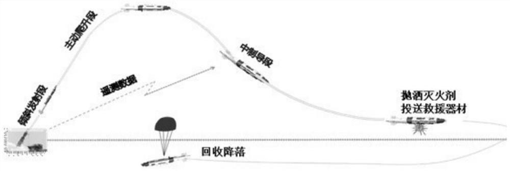
[0040] A forest fire guidance flight system includes: a launching platform, a command vehicle, an unmanned aerial vehicle, a reconnaissance vehicle and a carrier. The reconnaissance vehicle is used to assess the situation of the fire scene, and the UAV is used to transmit back the fire situation on the spot in real time; the command vehicle is used to receive the report of the reconnaissance vehicle and the on-site fire situation returned by the UAV, and send the location coordinates of the fire scene to the launch platform; The launch platform includes a ground launch platform or an air launch platform, and the launch platform is used to launch a carrier with a large load. Launching the vehicle from the launch platform is based on calculating the distance between the fire source and the launch platform, and initially calculating the effective range; within the effective range, the launch direction of the vehicle is determined according to the position of the fire source and th...
Embodiment 2
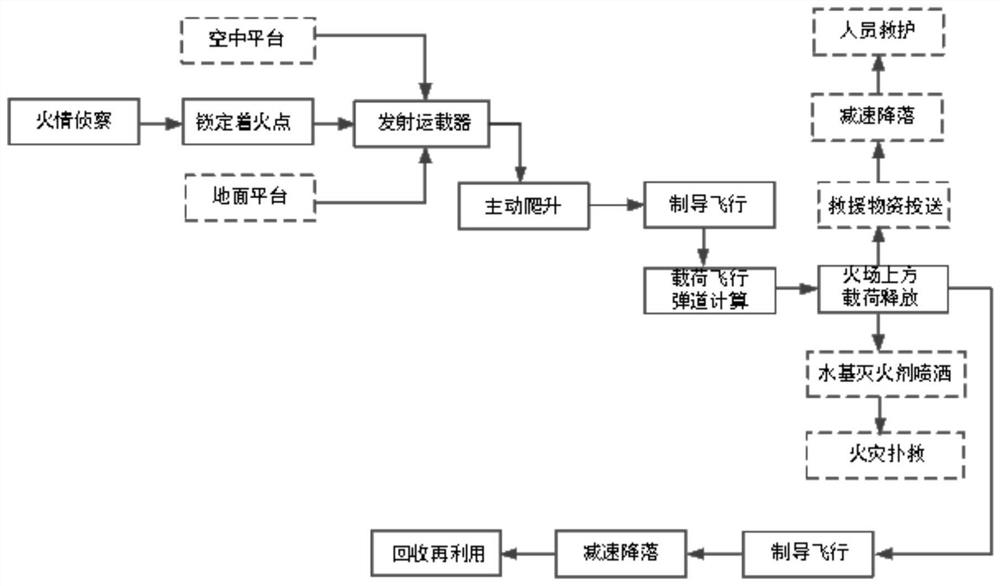
[0068] Such as figure 2 Shown, based on above-mentioned a kind of forest fire guidance flight system, its specific operation method comprises the following steps:
[0069] 1. The scout vehicle scouts the fire;
[0070] After ground patrol and air patrol personnel conduct forest fire reconnaissance, they find and lock the fire direction, send reconnaissance vehicles to conduct fire reconnaissance, and obtain the specific location of the fire point.
[0071] 2. The unmanned aerial vehicle sends back the scene of the fire in real time;
[0072] The aerial UAV conducts fire investigation at the same time, combined with the specific location of the ignition point transmitted by the reconnaissance vehicle, conducts the investigation of the ignition situation and the actual geographical conditions around the location of the ignition point, and sends back information in real time.
[0073] 3. The command vehicle receives the report of the reconnaissance vehicle and the on-site fire...
Embodiment 3
[0081] Such as figure 2 As shown, the present embodiment provides a forest fire guidance flight system and operation method, comprising the following steps:
[0082] Step 1: Fire detection, locking the ignition point, and obtaining the location of the ignition point;
[0083] After the ground reconnaissance vehicles and aerial drones detect the forest fire, they lock the fire point and obtain the location coordinates of the fire point. Ground reconnaissance vehicles use long-distance infrared, laser and visible light detection methods or carry photoelectric pods through aerial drones to detect forest fires and obtain relatively accurate fire points, including spatial azimuth angles and distance information, etc. , as rough target information for vehicle launches.
[0084] Step 2: Launch the platform and launch the vehicle;
[0085] Under the guidance of the position detected by the scout vehicle and the UAV, the launch platform obtains the initial rough position informatio...
PUM
 Abstract
Description
Claims
Application Information
 - R&D
- Intellectual Property
- Life Sciences
- Materials
- Tech Scout
- Unparalleled Data Quality
- Higher Quality Content
- 60% Fewer Hallucinations
Browse by: Latest US Patents, China's latest patents, Technical Efficacy Thesaurus, Application Domain, Technology Topic, Popular Technical Reports.
© 2025 PatSnap. All rights reserved.Legal|Privacy policy|Modern Slavery Act Transparency Statement|Sitemap|About US| Contact US: help@patsnap.com


