
Building live-action map making method and system

A technology of real-scene maps and production methods, applied in maps/plans/charts, instruments, geometric CAD, etc., can solve the problem that model results cannot be effectively applied to refined 3D scene indoor positioning and navigation, etc., to achieve effective positioning and navigation, and improve The effect of precision

Active Publication Date: 2020-04-14
BEIJING UNIVERSITY OF CIVIL ENGINEERING AND ARCHITECTURE
View PDF5 Cites 7 Cited by
  • Summary
  • Abstract
  • Description
  • Claims
  • Application Information

AI Technical Summary

Problems solved by technology

The current 3D reality model construction methods mainly include traditional manual modeling, oblique photography automatic modeling, and 3D laser scanning modeling methods, all of which have their own advantages and limitations, and the model results cannot be effectively applied to fine 3D scene indoors. Positioning and Navigation

Method used


Image

  • Building live-action map making method and system
  • Building live-action map making method and system
  • Building live-action map making method and system

Examples


Embodiment Construction

[0033] In order to make the purpose, technical solutions and advantages of the embodiments of the present invention clearer, the technical solutions in the embodiments of the present invention will be clearly and completely described below in conjunction with the drawings in the embodiments of the present invention. Obviously, the described embodiments It is a part of embodiments of the present invention, but not all embodiments. Based on the embodiments of the present invention, all other embodiments obtained by persons of ordinary skill in the art without creative efforts fall within the protection scope of the present invention.

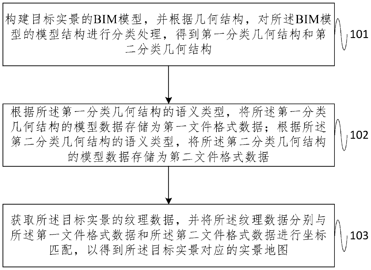
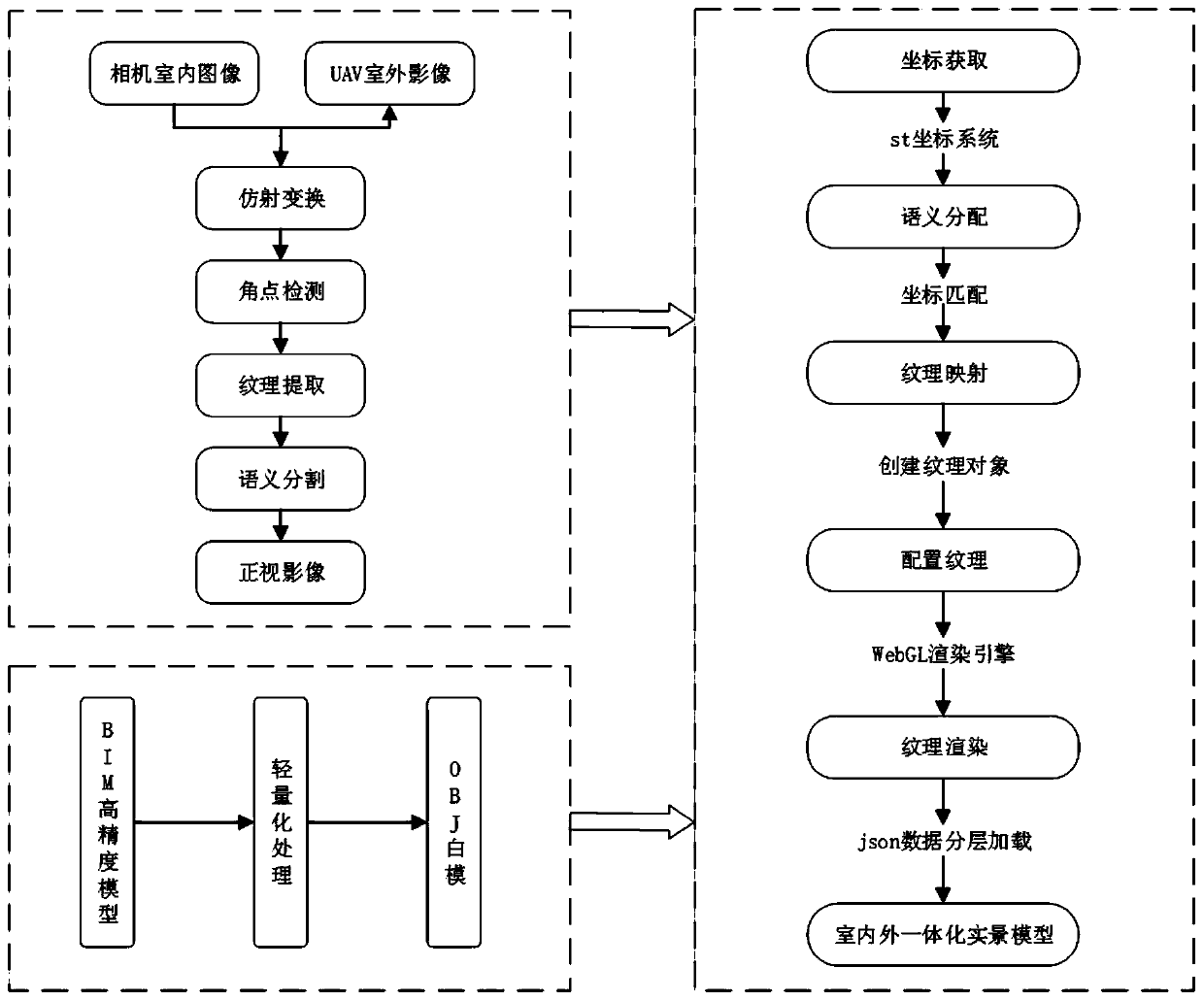
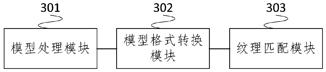
[0034] In recent years, with the widespread application of building information modeling (BIM) in the field of construction technology, the combination of BIM and surveying and mapping geographic information industry has become a new research field. BIM technology has effectively promoted the design efficiency and quality improvement of building d...


PUM


Abstract

The embodiment of the invention provides a building live-action map making method and system. The method comprises the steps of building a BIM model of a target live-action, carrying out the classification of a model structure of the BIM model according to a geometric structure, and obtaining a first classification geometric structure and a second classification geometric structure; according to the semantic type of the first classification geometric structure, storing the model data of the first classification geometric structure as first file format data; according to the semantic type of the second classification geometric structure, storing the model data of the second classification geometric structure as second file format data; and obtaining texture data of the target live-action, and performing coordinate matching on the texture data and the first file format data and the second file format data to obtain a live-action map corresponding to the target live-action. According to the embodiment of the invention, the precision of the indoor and outdoor live-action maps of a building is improved, so that the building live-action maps are more effectively applied to positioning and navigation of a three-dimensional scene.

Description

technical field [0001] The invention relates to the technical field of map making, in particular to a method and system for making a building real-scene map. Background technique [0002] With the rapid development of mobile geographic information system (Geographic Information System, referred to as GIS), smart phones, close-range photography, augmented reality, deep learning and other disciplines, the current integration of these technologies and oriented location-based service (Location Based Service, referred to as LBS) The needs of the public can no longer be satisfied with the positioning and navigation service mode of the existing two-dimensional planar map scene, and the application research on "immersive" real-scene indoor positioning and navigation has shown a rapid growth trend. However, at present, there is no effective and complete solution to scientific problems such as efficient construction of indoor and outdoor 3D real-scene maps of buildings and indoor posi...

Claims


Application Information

Patent Timeline
IPC IPC(8): G06F30/13G09B29/00G06F111/20
CPCG09B29/005G09B29/004
Inventor 刘建华李聪聪罗竟妍李司宇冯国强温丹祺
Owner BEIJING UNIVERSITY OF CIVIL ENGINEERING AND ARCHITECTURE
Features
  • Generate Ideas
  • Intellectual Property
  • Life Sciences
  • Materials
  • Tech Scout
  • Unparalleled Data Quality
  • Higher Quality Content
  • 60% Fewer Hallucinations
Learn More