Topographic survey method and system

A topographic measurement and reference system technology, applied in the agricultural field, can solve the problems of reducing the accuracy of three-dimensional topographic measurement of farmland, and achieve the effect of overcoming the small amount of terrain information collection and improving measurement accuracy

Inactive Publication Date: 2020-04-28
CHINA AGRI UNIV
View PDF3 Cites 7 Cited by
  • Summary
  • Abstract
  • Description
  • Claims
  • Application Information

AI Technical Summary

Problems solved by technology

[0005] This method ignores the data acquisition errors caused by external factors such as mechanical vibration of the system, attitude changes of the lev

Method used


Image

  • Topographic survey method and system
  • Topographic survey method and system
  • Topographic survey method and system

Examples


Embodiment Construction

[0048] In order to make the purpose, technical solutions and advantages of the embodiments of the present invention clearer, the technical solutions in the embodiments of the present invention will be clearly and completely described below in conjunction with the drawings in the embodiments of the present invention. Obviously, the described embodiments It is a part of embodiments of the present invention, but not all embodiments. Based on the embodiments of the present invention, all other embodiments obtained by persons of ordinary skill in the art without creative efforts fall within the protection scope of the present invention.

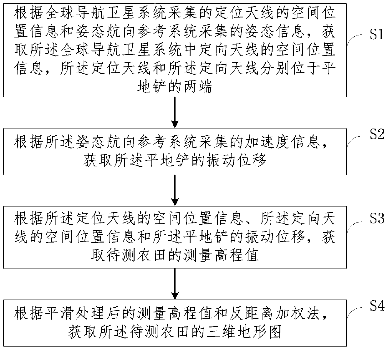
[0049] In order to overcome the above-mentioned problems or at least partially solve the above-mentioned problems, an embodiment of the present invention provides a topographic measurement method, which is used to effectively eliminate the vibration error caused by the attitude change of the shovel and the terrain fluctuation during the topographic...


PUM


Abstract

The embodiment of the invention provides a topographic survey method and system. The method comprises the steps: acquiring spatial position information of a directional antenna in a global navigationsatellite system according to spatial position information, collected by the global navigation satellite system, of a positioning antenna and attitude information collected by an attitude heading reference system; acquiring the vibration displacement of a land leveling shovel according to acceleration information acquired by the attitude heading reference system; acquiring a measurement elevationvalue of a to-be-measured farmland according to the spatial position information of the positioning antenna, the spatial position information of the directional antenna and the vibration displacementof the land leveling shovel; and acquiring a three-dimensional topographic map of the to-be-measured farmland according to the measurement elevation value after smoothing processing and an inverse distance weighting method. According to the embodiment of the invention, topographic survey is carried out on the farmland by adopting the method, problems that a traditional GNSS farmland leveling system is small in topographic information acquisition quantity in the topographic survey process and the GNSS antenna is influenced by the system environment to cause inaccurate acquired data are effectively solved, and the topographic information measurement precision is improved.

Description

technical field [0001] The invention relates to the field of agricultural technology, in particular to a topographic measurement method and system. Background technique [0002] The farmland leveling technology based on the Global Navigation Satellite System (GNSS) plays an important role in water-saving irrigation, land utilization, fertilizer conservation and yield increase, and is one of the important research contents of modern precision agriculture. Topographic survey is a necessary part of farmland leveling operations. By measuring the topography of unleveled farmland, accurate position and elevation information can be obtained, which can be used for farmland leveling path planning, and at the same time for the calculation of excavated and filled earthwork and the operation effect of the leveling work. Evaluation provides technical support. [0003] GNSS measurement technology can quickly and efficiently obtain three-dimensional topographic information of farmland. Wi...

Claims


Application Information

Patent Timeline
IPC IPC(8): G01C15/00
CPCG01C15/00
Inventor 刘刚景云鹏金志坤
Owner CHINA AGRI UNIV
Why Eureka
Try Eureka