Supercharge Your Innovation With Domain-Expert AI Agents!

Method and system for generating pollutant road map based on discrete monitoring point data

A technology for generating systems and monitoring points, which is applied in the field of pollutant monitoring and can solve problems such as poor visualization effects and unfavorable air quality conditions

Active Publication Date: 2022-06-07
北京杰奕汇通咨询顾问有限公司
View PDF6 Cites 0 Cited by
  • Summary
  • Abstract
  • Description
  • Claims
  • Application Information

AI Technical Summary

Problems solved by technology

But even so, what this monitoring method feeds back is still the discrete monitoring point data with a relatively large resolution, and the air quality data traffic map generated according to the discrete monitoring point data with a large resolution is the visualization of the pollutant road map. The effect is poor, which is not conducive to the user's intuitive understanding of the surrounding air quality

Method used


Image

  • Method and system for generating pollutant road map based on discrete monitoring point data
  • Method and system for generating pollutant road map based on discrete monitoring point data
  • Method and system for generating pollutant road map based on discrete monitoring point data

Examples


Embodiment Construction

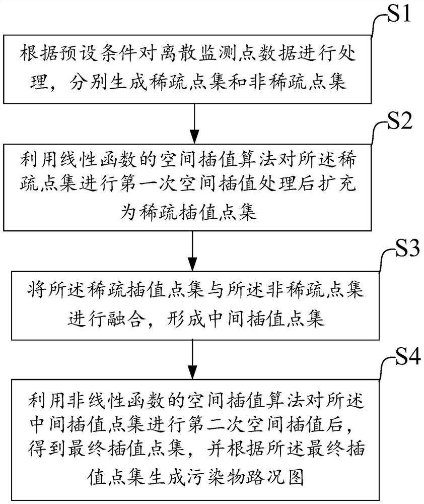
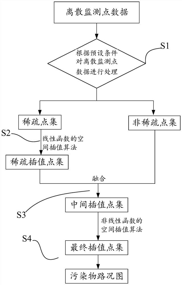
[0043] like figure 1 and figure 2 As shown, a method for generating a road condition map of pollutants based on discrete monitoring point data according to an embodiment of the present invention includes the following steps:

[0044] S1. Process discrete monitoring point data according to preset conditions, and generate sparse point sets and non-sparse point sets respectively;

[0045] S2, using the spatial interpolation algorithm of a linear function to perform the first spatial interpolation processing on the sparse point set and expand it into a sparse interpolation point set;

[0046] S3, fuse the sparse interpolation point set with the non-sparse point set to form an intermediate interpolation point set;

[0047] S4. After the second spatial interpolation is performed on the intermediate interpolation point set by using the spatial interpolation algorithm of the nonlinear function, a final interpolation point set is obtained, and a pollutant road condition map is gener...


PUM


Abstract

The invention relates to a method and system for generating a pollutant road condition map based on discrete monitoring point data, which generates sparse Point set and non-sparse point set, after the first spatial interpolation of the sparse point set, the number of data points in the sparse point set is increased to form a sparse interpolation point set, and then the sparse interpolation point set and the non-sparse point set are fused to form an intermediate The set of interpolated points. Then, the second spatial interpolation is performed on the intermediate interpolation point set, which is equivalent to further increasing the number of data points in the intermediate interpolation point set, generating the final interpolation point set, and then generating a finer pollutant road condition map based on the final interpolation point set. The details are richer, the visualization effect is better, and it is easier for users to observe intuitively.

Description

technical field [0001] The invention relates to the field of pollutant monitoring, in particular to a method and system for generating a road condition map of pollutants based on discrete monitoring point data. Background technique [0002] With the continuous improvement of people's living standards, people are paying more and more attention to the air quality of the living environment. In order to monitor changes in urban air quality more accurately and in real time, more and more air monitoring sites are deployed in cities. But even so, the feedback of this monitoring method is still discrete monitoring point data with larger resolution. The air quality data road condition map generated according to the discrete monitoring point data with larger resolution is the visualization of the pollutant road condition map. The effect is poor, and it is not conducive for users to intuitively understand the surrounding air quality. [0003] Therefore, how to generate a road map of ...

Claims


Application Information

Patent Timeline
Patent Type & Authority Patents(China)
IPC IPC(8): G01N15/06G01N33/00G06T3/40
CPCG01N15/06G01N33/0042G06T3/4007
Inventor 谭林华思洋
Owner 北京杰奕汇通咨询顾问有限公司
Features
  • R&D
  • Intellectual Property
  • Life Sciences
  • Materials
  • Tech Scout
  • Unparalleled Data Quality
  • Higher Quality Content
  • 60% Fewer Hallucinations
Learn More