Empirical ionospheric model data driving method based on GNSS measurement

A driving method and model data technology, which is applied in the direction of measurement devices, radiation measurement, radio wave measurement systems, etc., can solve problems such as inability to accurately give real-time change information and limit the application range of models

Active Publication Date: 2020-05-08
中国电波传播研究所
View PDF7 Cites 2 Cited by
  • Summary
  • Abstract
  • Description
  • Claims
  • Application Information

AI Technical Summary

Problems solved by technology

As a general climatological ionospheric model, the empirical ionospheric model can only describe the monthly average change state of the ionosphere, but cannot accurately provide real-time change information in the "meteorology" category of the ionosphere, which limits the scope of application of the model

Method used


Image

  • Empirical ionospheric model data driving method based on GNSS measurement
  • Empirical ionospheric model data driving method based on GNSS measurement
  • Empirical ionospheric model data driving method based on GNSS measurement

Examples


Embodiment 1

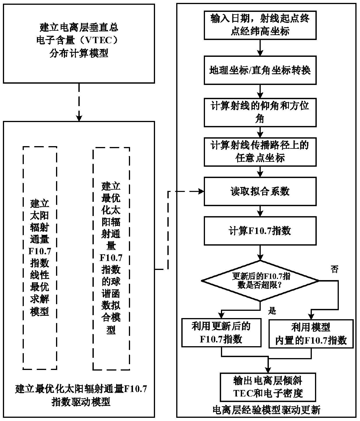
[0064] Example 1, such as figure 1 As shown, the present embodiment discloses a GNSS measurement-based empirical ionospheric model data-driven method, including the following steps:

[0065] Step 1. Establish a regional or global ionospheric vertical total electron content (VTEC) distribution calculation model based on GNSS measured data:

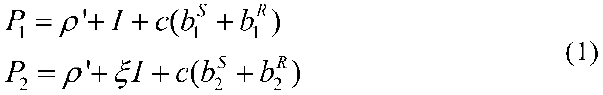
[0066] Establish GNSS-based code pseudo-range measurement equation:

[0067]

[0068] Where: P 1 and P 2 represent f respectively 1 and f 2 The code pseudo-range measurement value observed on the frequency band, ρ' represents the real distance between the satellite S and the receiver R, I represents the ionospheric delay, c is the speed of light, respectively represent the hardware delay of satellite S in the corresponding frequency band, Represent the hardware delay of satellite S in the corresponding frequency band;

[0069] Establish the GNSS-based carrier phase measurement equation:

[0070]

[0071] Among them: L 1 a...


PUM


Abstract

The invention discloses an empirical ionospheric model data driving method based on GNSS measurement. The method comprises the following steps: step 1, establishing a distribution calculation model ofa vertical total electron content of a regional or global ionospheric based on GNSS actually measured data; step 2, establishing an optimal solar radiation flux F10.7 index driving model based on ionospheric vertical total electron content information; and step 3, on the basis of the established ionospheric vertical total electron content distribution calculation model and the optimal solar radiation flux F10.7 index driving model, performing driving updating on the empirical ionospheric model, and outputting data-driven ionospheric tilt total electron content and electron density information. According to the GNSS-measurement-based empirical ionosphere model data driving method established by the invention, the solar radio flux F10.7 index of the empirical ionosphere model is driven andupdated by utilizing GNSS actually measured data, so that the prediction precision of output parameters of the empirical ionosphere model is effectively improved.

Description

technical field [0001] The invention belongs to the field of ionosphere research and application, in particular to an empirical ionosphere model data driving method based on GNSS measurement in the field. Background technique [0002] The empirical ionospheric model is constructed based on a variety of ground-based and satellite measurement data, which can describe the "climate" change state of the ionosphere in time and space dimensions. The model has important application value in the field of radio engineering research and design, and is widely used It is used in many systems such as short wave communication, satellite communication, satellite navigation, measurement, control and surveillance. As a general climatological ionospheric model, the empirical ionospheric model can only describe the monthly average change state of the ionosphere, but cannot accurately provide real-time change information in the "meteorology" category of the ionosphere, which limits the scope of ...

Claims


Application Information

Patent Timeline
Patent Type & Authority Applications(China)
IPC IPC(8): G01T1/29G01S19/37G06F17/11
CPCG01S19/37G01T1/2914G01T1/2992G06F17/11
Inventor 欧明陈亮冯健许娜陈龙江吴家燕於晓刘钝甄卫民
Owner 中国电波传播研究所
Why Eureka
Try Eureka