An underwater terrain measurement device based on vertical take-off and landing fixed-wing amphibious UAV

An amphibious, vertical take-off and landing technology, applied in the direction of measuring devices, radio wave measuring systems, seaplanes, etc., can solve the problems of difficulty in obtaining suitable ships, endangering the safety of equipment and personnel, and hidden dangers of personnel safety, so as to save manpower and cost Low, the effect of reducing the risk of damage

Active Publication Date: 2021-06-25
CHANGJIANG RIVER SCI RES INST CHANGJIANG WATER RESOURCES COMMISSION
View PDF9 Cites 1 Cited by
  • Summary
  • Abstract
  • Description
  • Claims
  • Application Information

AI Technical Summary

Problems solved by technology

Carrying it on manned ships or unmanned ships is the main working method of underwater topographic survey at present. However, in the application of manned ships, there are problems such as inconvenient measurement of nearshore shoals, difficulty in obtaining suitable ships, and hidden dangers to personnel safety; The surveying boat system can perfectly solve the problem of shallow water surveying, and can also be used in dangerous waters to ensure the safety of ships and personnel. It not only affects work efficiency, but also endangers the safety of equipment and personnel in severe cases. There is no effective solution at present

Method used


Image

  • An underwater terrain measurement device based on vertical take-off and landing fixed-wing amphibious UAV
  • An underwater terrain measurement device based on vertical take-off and landing fixed-wing amphibious UAV
  • An underwater terrain measurement device based on vertical take-off and landing fixed-wing amphibious UAV

Examples


Embodiment Construction

[0023] In order to make the purpose, technical solutions and advantages of the present invention clearer, the technical solutions in the embodiments of the present invention will be clearly and completely described below in conjunction with the accompanying drawings of the present invention. Apparently, the described embodiments are some, but not all, embodiments of the present invention. Based on the embodiments of the present invention, all other embodiments obtained by persons of ordinary skill in the art without creative efforts fall within the protection scope of the present invention.

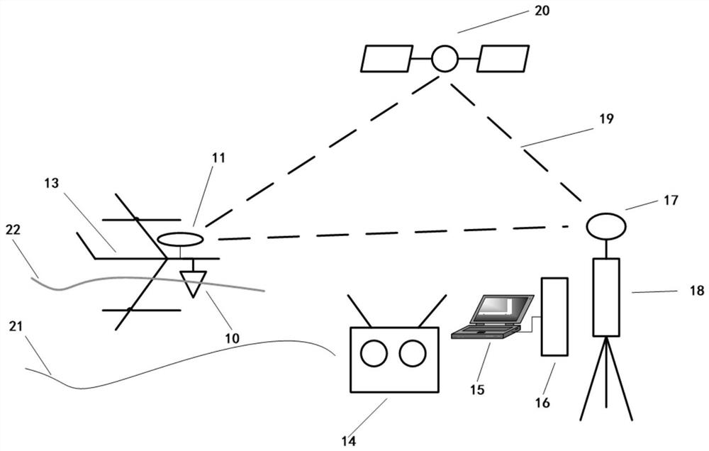
[0024] Such as figure 1 Shown, a kind of underwater terrain measurement device based on vertical take-off and landing fixed-wing amphibious UAV, including amphibious UAV 13, GPS reference station 18 (carrying out long-term continuous observation to satellite navigation signal, and by communication facility will The observation data are transmitted to the ground fixed observation station ...


PUM


Abstract

The present invention provides an underwater terrain measurement device based on a vertical take-off and landing fixed-wing amphibious UAV, including an amphibious UAV, a GPS reference station, a main control device and a remote control device, and the remote control device, the main control device and the amphibious The UAV is connected by wireless communication, and the remote control device and the main control device are used to control the operation of the amphibious UAV on the shore of the measured waters; It can navigate on the water surface during surveying and mapping; the amphibious UAV is equipped with a depth sounder and an airborne GPS rover, wherein the airborne GPS rover cooperates with the GPS reference station to obtain plane coordinates, and the depth sounder is used for amphibious drones. The man-machine acquires water depth data while navigating on the water surface. The invention can efficiently go deep into dangerous and complex waters and carry out operations, and can meet the needs of underwater terrain measurement of medium and small rivers, lakes and reservoirs.

Description

technical field [0001] The invention relates to the technical field of underwater terrain measurement equipment, in particular to an underwater terrain measurement device based on a vertical take-off and landing fixed-wing amphibious unmanned aerial vehicle, which is suitable for automatic measurement of underwater terrain in the context of steep banks. Landing fixed-wing amphibious aircraft is a water propulsion carrier, using GPS system and single-beam sounding system to detect the underwater terrain of small and medium-sized rivers and lakes. Background technique [0002] Underwater topographic surveying is the process of using surveying instruments to determine the three-dimensional coordinates of underwater points, and it is an important part of river, lake, and seabed surveying. Its key links are bathymetry and positioning. Bathymetry is to measure the height from the bottom point to the water surface, and to measure the depth of the depth points (called bathymetric po...

Claims


Application Information

Patent Timeline
Patent Type & Authority Patents(China)
IPC IPC(8): B64C35/00B63C11/52B63G8/00G01S19/41G01C7/02
CPCB63C11/52B63G8/001B63G2008/005B64C35/001B64C35/008G01C7/02G01S19/41
Inventor 洪晓峰许继军王永强霍军军陈广才潘登方易小锁
Owner CHANGJIANG RIVER SCI RES INST CHANGJIANG WATER RESOURCES COMMISSION
Why Eureka
Try Eureka