Unmanned aerial vehicle path planning system and method for distributed encouraging spatio-temporal data exploration

A space-time data and path planning technology, applied in control/adjustment system, vehicle position/route/height control, non-electric variable control, etc., can solve problems such as uneven distribution of target points and unmanned aerial vehicles unable to continuously perform long-term tasks

Active Publication Date: 2020-05-15
BEIJING INSTITUTE OF TECHNOLOGYGY
View PDF4 Cites 12 Cited by
  • Summary
  • Abstract
  • Description
  • Claims
  • Application Information

AI Technical Summary

Problems solved by technology

It can realize the self-charging of drones while performing tasks, which reduces the cost of human maintenance and solves the shortcoming that drones cannot continuously perform long-term tasks
Moreover, a spatio-temporal data exploration module based on the location information of the UAV is also introduced. Based on the location information of the UAV, by generating intrinsic rewards, the UAV is encouraged to patrol the target points that are less explored, thus solving the huge exploration problem. The problem of uneven distribution of target points in space

Method used


Image

  • Unmanned aerial vehicle path planning system and method for distributed encouraging spatio-temporal data exploration
  • Unmanned aerial vehicle path planning system and method for distributed encouraging spatio-temporal data exploration
  • Unmanned aerial vehicle path planning system and method for distributed encouraging spatio-temporal data exploration

Examples


Embodiment 1

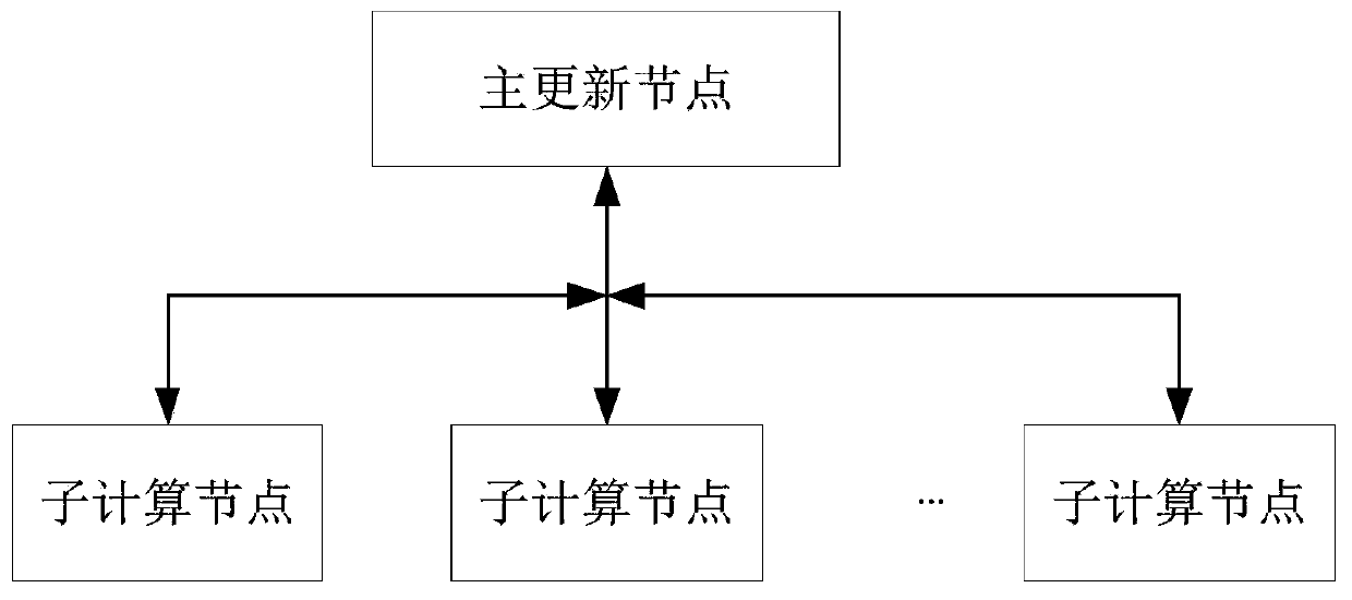
[0084] Embodiment 1: A distributed UAV path planning system that encourages spatio-temporal data exploration, such as figure 1 As shown, including: the main update node and multiple sub-computing nodes; where each sub-computing node performs calculations on multiple UAVs;

[0085] The sub-computing node is used to calculate the state information of multiple unmanned aerial vehicles and equipment in the inspection area based on the neural network learning algorithm, and push the gradient of the neural network parameters to the main update node; The main update section obtains network parameters, and performs UAV position planning and action planning based on the network parameters; and broadcasts the UAV position planning and action planning to all UAVs corresponding to the computing node;

[0086] The main update node is used to update the network parameters according to the gradients pushed by all sub-computing nodes, and publish to all sub-nodes;

[0087] Wherein, the state...

Embodiment 2

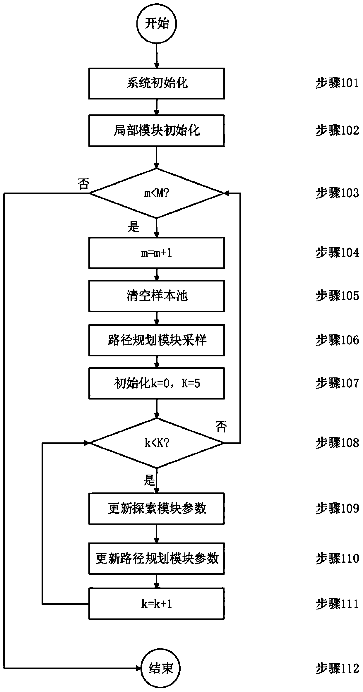
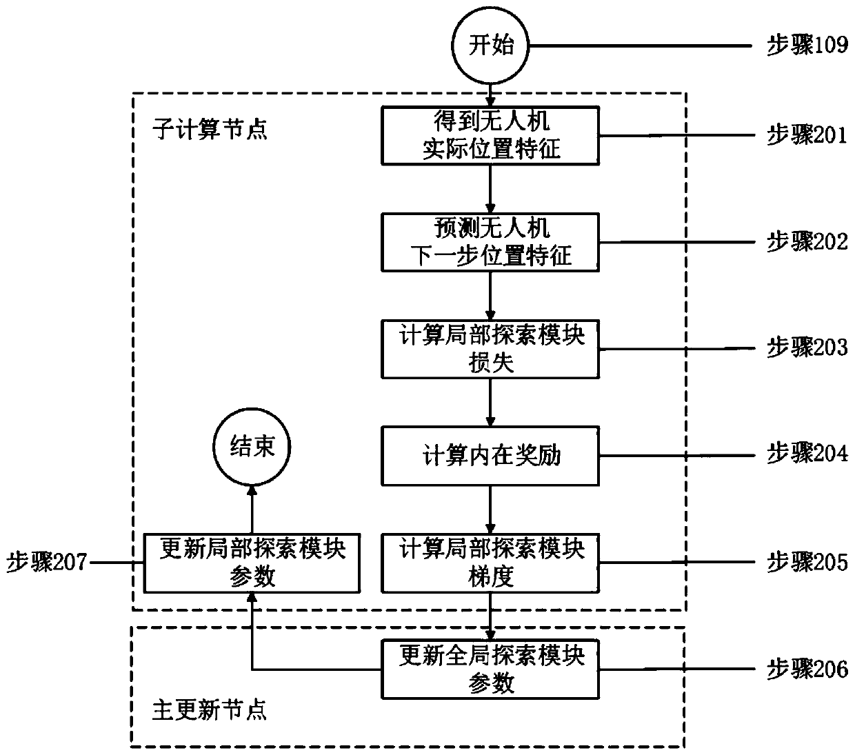
[0115] combine figure 2 , to describe this example in detail:

[0116] Step 101: system initialization.

[0117] Initialize the number of training iterations m=0, the total number of training iterations M=2500, and the number of drones N. In the general update node, the network parameters in the multi-UAV path planning module (hereinafter referred to as the path planning module) and the spatio-temporal data exploration module (hereinafter referred to as the exploration module) are randomly initialized.

[0118] Step 102: Local module initialization.

[0119] In each sub-computing node, the local path planning module and the local exploration module copy the network parameters from the global path planning module and the global exploration module respectively.

[0120] Step 103: judge m

[0121] Specifically, if m

[0122] Step 104: m=m+1.

[0123] Step 105: Empty the sample pool.

[0124] On each child compute node, empt...


PUM


Abstract

The invention discloses an unmanned aerial vehicle path planning system for distributed encouraging spatio-temporal data exploration. The unmanned aerial vehicle path planning system comprises a mainupdating node and a plurality of sub-computing nodes, wherein each sub-computing node computes a plurality of unmanned aerial vehicles; the sub-computing nodes are used for computing the state information of multiple unmanned aerial vehicles and the equipment in the inspection area based on a neural network learning algorithm and pushing the gradient of neural network parameters to the main updating node and also acquiring network parameters from the main updating node and performing unmanned aerial vehicle position planning and action planning based on the network parameters and broadcastingthe unmanned aerial vehicle position plans and the action plans to all the unmanned aerial vehicles corresponding to the computing nodes; the main updating node is used for updating the network parameters according to the gradient pushed by all the sub-computing nodes and issuing the network parameters to all the sub-nodes. According to the technical scheme, the calculation efficiency is improvedand the charging problem of the unmanned aerial vehicle is solved.

Description

technical field [0001] The present invention relates to the field of path planning, in particular to a distributed UAV path planning system and method that encourages spatio-temporal data exploration. Background technique [0002] Unmanned aircraft, referred to as unmanned aerial vehicles, its value lies in forming an aerial platform to replace humans to complete aerial operations. With the successful deployment of motion cameras, laser radars, night vision devices, zoom lenses and other sensing instruments on UAVs, UAV technology is becoming more and more mature, manufacturing costs are greatly reduced, and it has been widely used in various fields, such as: smart transportation , disaster relief, military coordinated operations, agricultural plant protection, geological exploration, environmental monitoring, forest fire prevention, etc. [0003] For example, by taking advantage of the characteristics of high cruising height, long communication distance and full shooting a...

Claims


Application Information

Patent Timeline
Patent Type & Authority Applications(China)
IPC IPC(8): G05D1/10
CPCG05D1/101
Inventor 刘驰赵一诺
Owner BEIJING INSTITUTE OF TECHNOLOGYGY
Why Eureka
Try Eureka