Unmanned aerial vehicle multi-dimensional recognition system and method

A technology for identifying systems and drones, applied in geophysical surveys, instruments, etc., can solve the problems of rapid and accurate detection of drones, inability to give judgment results, etc., to overcome shortcomings and loopholes, accurate judgment results, and high detection effect of probability

Active Publication Date: 2020-05-29
CHANGCHUN UNIV OF SCI & TECH
View PDF13 Cites 0 Cited by
  • Summary
  • Abstract
  • Description
  • Claims
  • Application Information

AI Technical Summary

Problems solved by technology

[0004] The purpose of the present invention is to propose a multi-dimensional identification system and method for unmanned aerial vehicles to solve the problems in the prior art that the unmanned aerial vehicles cannot be quickly and accurately detected in the range of long-distance and variable distances and cannot give accurate judgment results

Method used


Image

  • Unmanned aerial vehicle multi-dimensional recognition system and method
  • Unmanned aerial vehicle multi-dimensional recognition system and method
  • Unmanned aerial vehicle multi-dimensional recognition system and method

Examples


Embodiment Construction

[0027] Embodiments of the present invention will be further described below in conjunction with the accompanying drawings.

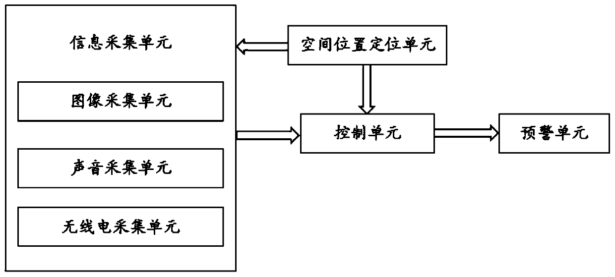
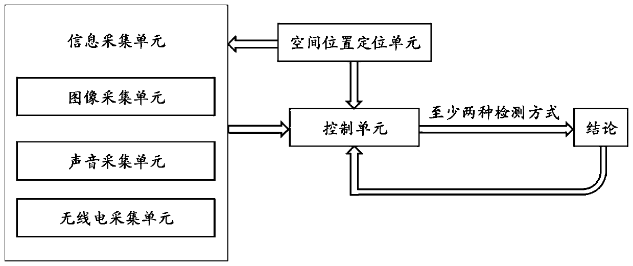
[0028] See attached figure 1 , a UAV multi-dimensional identification system of the present invention includes an information collection unit, a spatial position positioning unit, a control unit and an early warning unit;

[0029] The information collection unit includes an image collection unit, a sound collection unit, and a radio signal collection unit, and the image information of the drone, the sound information of the drone, and the radio signal in the target area are collected by the information collection unit and transmitted to the control unit;

[0030] The spatial position positioning unit obtains the spatial position information of the drone and transmits it to the control unit;

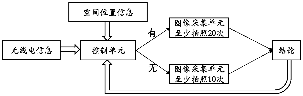
[0031] The control unit judges whether it is a drone according to the information obtained by the information collection unit and the spatial position positioning ...


PUM


Abstract

The invention discloses an unmanned aerial vehicle multi-dimensional recognition system and method, belongs to the technical field of anti-unmanned aerial vehicle recognition, and aims to solve the problems that the unmanned aerial vehicle cannot be quickly and accurately detected in a long-distance and variable-distance range and an accurate judgment result cannot be given in the prior art. The unmanned aerial vehicle multi-dimensional recognition system comprises an information acquisition unit, a spatial position positioning unit, a control unit and an early warning unit. The information acquisition unit comprises an image acquisition unit, a sound acquisition unit and a radio signal acquisition unit. Unmanned aerial vehicle image information, unmanned aerial vehicle sound information and radio signals in the target area are acquired through the information acquisition unit and transmitted to the control unit. The spatial position positioning unit acquires spatial position information of the unmanned aerial vehicle and transmits the spatial position information to the control unit; and the control unit judges whether the unmanned aerial vehicle is an unmanned aerial vehicle or not according to the information acquired by the information acquisition unit and the spatial position positioning unit and transmits a judgment result to the early warning unit.

Description

technical field [0001] The invention belongs to the technical field of anti-drone identification, and in particular relates to a multi-dimensional identification system and method for an unmanned aerial vehicle. Background technique [0002] In recent years, with the rapid development of the drone industry, the price of drones has become lower and lower. However, due to the lack of a sound management system, the safety issues caused by the "black flight" of drones have also attracted people's attention. In January 2017, Hangzhou Xiaoshan Airport took aerial photography drones to shoot passenger plane incidents; in April 2017, Sichuan Shuangliu Airport continued to have fixed-wing aircraft models interfere with passenger planes, causing hundreds of flights to divert or return, and more than 10,000 passengers were blocked and stranded The economic loss of the airport is tens of millions of yuan. The safety problems caused by drones are various, which have caused great securit...

Claims


Application Information

Patent Timeline
Patent Type & Authority Applications(China)
IPC IPC(8): G01V11/00
CPCG01V11/00
Inventor 薛珊李广青张振吕琼莹
Owner CHANGCHUN UNIV OF SCI & TECH
Why Eureka
Try Eureka