OTT data position-based intelligent correction method and device

A data location and data technology, which is applied in the field of intelligent deviation correction based on OTT data location, and can solve problems such as inability to directly obtain coordinate system information and user position deviation.

Inactive Publication Date: 2020-06-02
NANJING HOWSO TECH
View PDF3 Cites 0 Cited by
  • Summary
  • Abstract
  • Description
  • Claims
  • Application Information

AI Technical Summary

Problems solved by technology

At present, there are three kinds of coordinate systems commonly used by OTT service providers, but the coordinate system informat

Method used


Image

  • OTT data position-based intelligent correction method and device
  • OTT data position-based intelligent correction method and device
  • OTT data position-based intelligent correction method and device

Examples


Embodiment 1

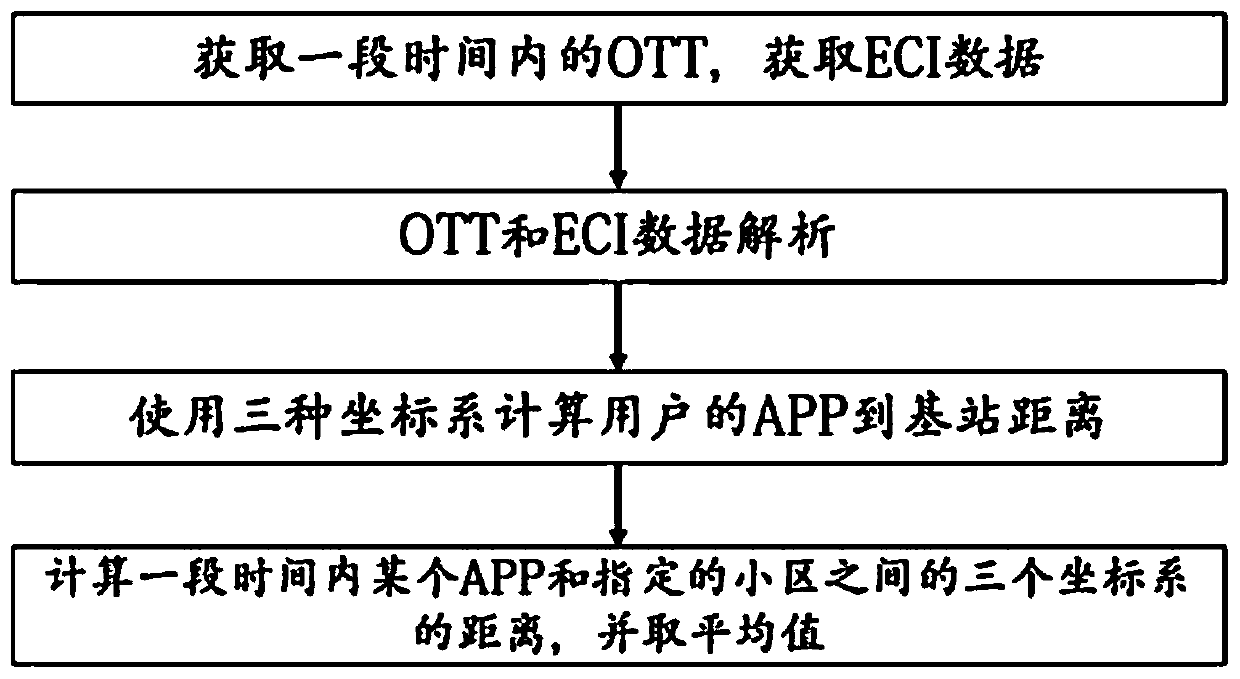
[0044] Embodiment 1: as figure 1 As shown, the method for intelligent deviation correction based on OTT data position includes the following steps:

[0045] (1) Obtain OTT data within a set period of time, and obtain ECI data within the same period of time;

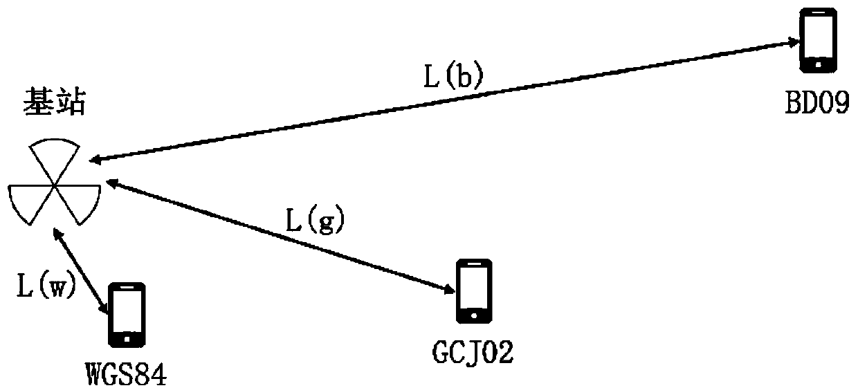
[0046] The OTT data in the described step (1) includes the APP name comprising the mobile terminal, the latitude and longitude of the user when using the APP, and the basic information of the cell; the ECI data includes the cell identity and the latitude and longitude of the cell; wherein the latitude and longitude of the user when using the APP is the value used by the APP. The coordinate system is a reference, one of three coordinate systems; the method obtained in the step (1) is file import or collection from a DPI server;

[0047] The setting time period of described step (1) is one day or one week; By setting a period of time, obtain the OTT data in this period of time, obtain a large amount of OTT data, thereby impr...

Embodiment 2

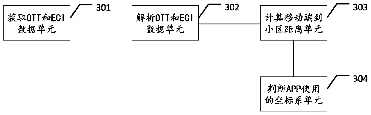
[0060] Embodiment 2: as image 3 As shown, the device using the OTT data position intelligent correction method of the above-mentioned embodiment 1, the OTT data position intelligent correction device includes obtaining the OTT and ECI data unit 301, analyzing the OTT and ECI data unit 302, calculating the mobile terminal To the cell distance unit 303 and determine the coordinate system unit 304 used by the APP;

[0061] Wherein, the unit 301 for obtaining OTT and ECI data is used to obtain OTT data within a period of time, the data includes the longitude and latitude of the location of the APP identification, the mobile terminal, and the identification of the connecting cell; obtains ECI data, and the data includes the identification of the cell, the cell Information such as latitude and longitude; acquisition methods include importing files or collecting from DPI servers;

[0062] Parsing OTT and ECI data unit 302, for parsing the longitude and latitude of the APP mark in t...

Embodiment 3

[0065] Embodiment 3: The case of adopting the method for intelligent deviation correction based on OTT data position of Embodiment 1 and the device of intelligent correction based on OTT data position of Embodiment 2 is:

[0066] (1) Obtain OTT data within a set period of time, and obtain ECI data within the same period of time;

[0067] (2) OTT and ECI data analysis;

[0068] Obtain the APP identification (host), the longitude (longitude) when the user uses the APP, the latitude (latitude) and the cell ID (cellid) when the user uses the APP from the OTT data; get the following table 1;

[0069] Obtain the identification (cellid), the longitude (longitude) of the community, the latitude (latitude) of the community from the ECI data; obtain the following table 2;

[0070] Table 1 Parsed OTT data

[0071] imsi Community ID host longitude latitude 460075678112669 2382348 api.diditaxi.com.cn 123.4445 41.8013 460075678112669 2382348 api.diditaxi....


PUM


Abstract

The invention relates to an OTT data position-based intelligent correction method and device, wherein the method comprises the following steps of (1), obtaining the OTT data in a set time period, andobtaining the ECI data in the same time period; (2) analyzing the OTT data and the ECI data obtained in the step (1); (3) converting the coordinates of the analyzed OTT data to obtain the converted coordinates under different coordinate systems; calculating the distances between the converted coordinates and the positions of the corresponding cell identifiers respectively to obtain the distance from the position of a mobile terminal to a base station; (4) respectively averaging the distances calculated in the step (3) under different coordinate systems so as to obtain a coordinate system of the mobile terminal. The OTT data position-based intelligent correction device comprises an OTT and ECI data acquisition unit, an OTT and ECI data analysis unit, a mobile terminal-to-cell distance calculation unit and a coordinate system unit for judging APP usage.

Description

technical field [0001] The present invention relates to the field of geographic location of mobile terminals, in particular to a method and device for intelligent deviation correction based on OTT data location. Background technique [0002] The acquisition of user location information can provide data basis for business hall location selection, key business marketing, urban construction planning, traffic planning, business district expansion, exhibition services, and advertising placement, so the accuracy of user location is particularly important. [0003] OTT service providers provide users with positioning and navigation services. The APP will report the location information, and can extract the latitude and longitude information to describe the user's movement trajectory. Since the longitude and latitude obtained by this positioning method come from the OTT application, it is called OTT positioning. At present, there are three kinds of coordinate systems commonly used ...

Claims


Application Information

Patent Timeline
IPC IPC(8): G01S19/42
CPCG01S19/42
Inventor 余健宋博梁泉
Owner NANJING HOWSO TECH
Why Eureka
Try Eureka