
Pseudo point cloud data generation method of laser radar

A lidar and cloud data technology, applied in image data processing, instruments, 3D modeling, etc., can solve the problems of inaccuracy, coarse granularity of point cloud data in time and space, and low scanning frequency of lidar, so as to improve The effect of granularity and precision

Active Publication Date: 2020-06-16
CRRC QINGDAO SIFANG ROLLING STOCK RES INST
View PDF6 Cites 5 Cited by
  • Summary
  • Abstract
  • Description
  • Claims
  • Application Information

AI Technical Summary

Problems solved by technology

[0005] The purpose of the present invention is to address the defects of the prior art, to provide a pseudo point cloud data generation method for laser radar, to solve the problem that the scanning frequency of laser radar is too low, and the point cloud data generated by scanning is coarse in time and space and inaccurate question

Method used


Image

  • Pseudo point cloud data generation method of laser radar
  • Pseudo point cloud data generation method of laser radar
  • Pseudo point cloud data generation method of laser radar

Examples


Embodiment Construction

[0036] The technical solutions of the present invention will be described in further detail below with reference to the accompanying drawings and embodiments.

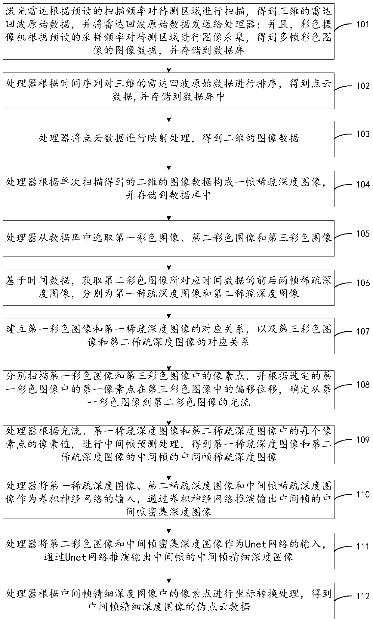
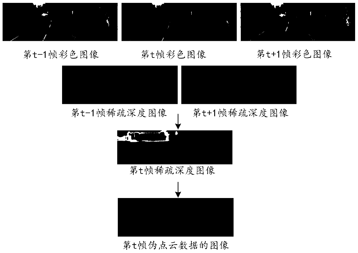
[0037] The pseudo point cloud data generation method of lidar provided by the present invention uses the optical flow of the color image corresponding to the sparse depth map of two consecutive frames to replace the optical flow of the sparse depth map, and obtains the middle frame of the two consecutive frames by interpolation depth map, and further interpolation calculation can be performed based on the obtained intermediate frame and the previous or subsequent frame to obtain the depth map of the intermediate frame between them, so that higher scanning frequency can be obtained without changing the actual lidar scanning frequency The data obtained by frequency scanning improves the granularity and accuracy of point cloud data in time and space.

[0038] figure 1 The flow diagram of the pseudo point cloud data gener...


PUM


Abstract

The invention relates to a pseudo point cloud data generation method of a laser radar. The method comprises the steps of by a processor, selecting a first color image, a second color image and a thirdcolor image, based on time data, obtaining two frames of sparse depth images before and after the time data corresponding to the second color image, namely a first sparse depth image and a second sparse depth image, determining an optical flow according to the offset displacement of the selected first pixel point, obtaining an intermediate frame sparse depth image according to the optical flow, the first sparse depth image and the second sparse depth image, taking the first sparse depth image, the second sparse depth image and the intermediate frame sparse depth image as inputs of a convolutional neural network, deducing and outputting an intermediate frame dense depth image, taking the second color image and the intermediate frame dense depth image as the input of a U-net network, deducing and outputting an intermediate frame fine depth image, and performing coordinate conversion processing according to pixel points in the intermediate frame fine depth image to obtain pseudo point cloud data of the intermediate frame fine depth image.

Description

technical field [0001] The invention relates to the technical field of laser radar, in particular to a method for generating pseudo point cloud data of laser radar. Background technique [0002] In recent years, the unmanned vehicle market has been booming. After Google, mainstream unmanned vehicle R&D teams such as Baidu and Uber all use lidar as one of the most important sensors, and use the combination of lidar and camera to realize Accurate judgment of obstacles and other information during unmanned driving. [0003] However, lidar has the following defects: (1) the data collected by lidar is very sparse, and only about 4% of the images in the 2D depth map obtained by projection of the collected point cloud data have pixel values; The scanning frequency is very low, usually about 10Hz for lidar sensors. At present, the highest scanning frequency on the market is Velodyne's 64-line 3D lidar, and its maximum scanning frequency can only reach 15Hz. [0004] Usually, the ...

Claims


Application Information

Patent Timeline
Patent Type & Authority Applications(China)
IPC IPC(8): G06T7/579G06T7/269G06T17/00
CPCG06T7/579G06T7/269G06T17/00G06T2207/10024G06T2207/10016G06T2207/20084G06T2207/30252Y02A90/10
Inventor 薛松王曙李德祥李文正李乾林春雨
Owner CRRC QINGDAO SIFANG ROLLING STOCK RES INST
Learn More